Situation Summary
Solomon Islands remains at low composite threat (rank #150 globally; score 5/100) with no verified security incidents, civil unrest, political violence, or infrastructure disruption reported in the last 24–48 hours. Nationwide operations at ports, airports, and transport remain normal. However, sub-national risk concentration in Honiara, Guadalcanal, and Malaita—driven by ongoing violent crime (home invasions, arson), policing capacity gaps, and historical communal tensions—warrants continued monitoring of those provinces. The country's security posture remains stable relative to regional peers, but localized criminal activity and logistical constraints in outer provinces persist as baseline concerns.
Key Developments
No specific, verifiable security, civil unrest, crime, or infrastructure incidents have been reliably dated to 18–19 July 2026 based on current open-source monitoring and cross-checked regional feeds. The most recent credible event signals include two minor seismic events (M 5.1 near Kirakira, Makira-Ulawa; M 4.4 near Lata, Temotu), both recorded earlier in the week with no reported damage or disruption.
Background context (not current developments): Calls for stronger policing and reports of violent crime (masked home invasions, arson targeting logging operations) in Central Guadalcanal have circulated in Pacific media as part of a broader recent crime surge, but precise incident dates remain unclear and fall outside the 24–48 hour window. Diplomatic criticism of China's mid-July submarine-launched ballistic missile test (13–17 July) by Solomon Islands and other Pacific leaders reflects regional security concerns but represents no new domestic incident.
Highest-Risk Areas
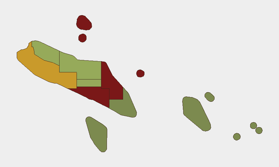
Honiara (risk 92) and Guadalcanal (risk 88) dominate sub-national threat concentration, with Malaita (risk 85) close behind. These three provinces account for the country's most significant crime, communal-tension, and policing-resource challenges. Honiara's urban density, informal settlement expansion, and port/commercial activity create environments favorable to property crime and organized theft; Guadalcanal's rural and semi-rural character has seen recent violent crime activity (home invasion, arson) amid logistical constraints and weaker state presence. Western (risk 72) and Choiseul (risk 58) present secondary concerns. Outer provinces (Temotu, Rennell-Bellona) carry minimal risk and operate with normal service availability.
How GeoBit Would Assist
Security teams with personnel or assets in Solomon Islands should employ AOI Monitoring & Early Warning on Honiara, Guadalcanal, and Malaita to detect emerging civil unrest, crime spikes, or political instability in near real-time. Multi-language OSINT (X/Twitter, Telegram, regional media feeds, YouTube) combined with sentiment and temporal analysis will surface local incident reports, community alerts, and official statements ahead of mainstream confirmation. Network & Actor Analysis on criminal and communal networks, alongside conflict and crime-focused search, will help identify escalation risks and protective routing. For field teams, Routing & Network Analysis can identify safer alternatives to high-risk zones in Honiara and Guadalcanal.
7-Day Outlook
No acute security deterioration is forecast for the next 7 days. Baseline violent crime and police-resource constraints in Guadalcanal and Malaita will likely persist at current levels. Continued monitoring of social media, community networks, and local media for signs of organized crime activity or communal tension is prudent; any rapid uptick in crime reports or political rhetoric should trigger elevated alertness in affected provinces.
Highest-Risk Areas — Ranked
| # | State / Region | Risk |
|---|---|---|
| 1 | Honiara | 92 |
| 2 | Guadalcanal | 88 |
| 3 | Malaita | 85 |
| 4 | Western | 72 |
| 5 | Choiseul | 58 |
| 6 | Isabel | 52 |
| 7 | Central Province | 48 |
| 8 | Makira-Ulawa | 38 |
| 9 | Rennell and Bellona | 22 |
| 10 | Temotu | 18 |
Sources
Previous Daily Briefs
A new Solomon Islands brief is written every day — each with its own risk map and downloadable CSV. Here's the last week; use the calendar to go further back.
📅 Browse every day by calendar →
Highlighted days have a brief. Tap a day for that day's map & analysis, or “csv” for that day's dataset ($5).
Atlas — our AI intelligence desk — emails them this snapshot personally. Nothing else, no list.