Situation Summary
South Sudan remains in a state of chronic political fragmentation and armed instability, with no major discrete security incidents reported in the last 24–48 hours but significant political developments signaling rising election-related tension. The National Salvation Front's 4 July rejection of the planned 22 December 2026 elections, combined with assertions of ongoing armed conflict and state control gaps across multiple regions, underscores the persistence of baseline insecurity and the emergence of a political fault line that could trigger localized violence or disruption. Current threat conditions remain elevated, particularly in the oil-producing north and eastern regions where armed groups operate and state authority is contested.
Key Developments
- Juba, 4 July 2026: National Salvation Front (NAS) issued a formal statement rejecting the planned 22 December 2026 national elections, characterizing them as a political exercise to legitimize President Salva Kiir rather than a genuine democratic process. The group called instead for comprehensive, inclusive negotiations before any vote, signaling potential for electoral boycott or confrontation.
- National level, 4 July 2026: NAS statement reasserted the persistence of armed conflict and widespread insecurity across South Sudan, with government forces and armed groups continuing to clash and large parts of the country remaining outside effective state control.
- Northern border areas, early July 2026: Humanitarian reporting indicates continued high-volume refugee and returnee flows from Sudan into transit centers such as Renk, with facilities operating at five times intended capacity and over 1 million people having fled into South Sudan since the Sudan war began in April 2023. Border areas remain under severe strain, raising localized risks of crime, disease, and tension.
- National institutions, early July 2026: UN emphasis on the 22 December elections as a key milestone tied to the renewed UNMISS mandate has created a convergence point between international pressure and armed-opposition resistance, positioning electoral preparations as a potential flashpoint for political instability.
Highest-Risk Areas
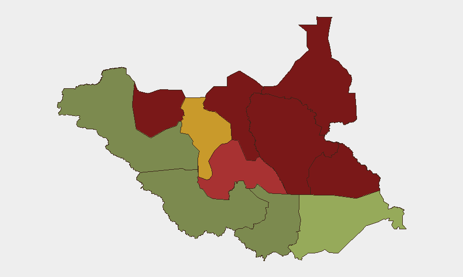
Unity, Jonglei, and Upper Nile states drive the highest composite threat scores (95, 93, and 88 respectively), driven by active armed-group presence, weak state capacity, and ongoing resource competition over oil and grazing lands. Greater Pibor Administrative Area (87) and Northern Bahr el Ghazal (82) remain high-risk due to intercommunal violence and armed-group activity. By contrast, the three Equatoria states and Western Bahr el Ghazal show significantly lower scores (38–52), reflecting greater state presence and reduced armed-group activity, though localized crime and banditry persist. Operations and personnel in northern and central-eastern regions face substantially higher exposure to armed confrontation, kidnapping, and disruption than those in the southern and western peripheries.
How GeoBit Would Assist
Security teams should deploy AOI Monitoring & Early Warning on the northern border transit hubs (Renk, Malakal) and key political centers (Juba) to detect incidents, protest activity, or force movements in near-real time. Network & Actor Analysis and election monitoring capabilities can track NAS statements, faction positioning, and electoral preparation signals to provide strategic early warning of political escalation. Conflict & Military force-structure and GIS & Spatial Analysis products enable teams to map armed-group positions and state-control boundaries, informing route planning and facility-security decisions in high-risk northern states.
7-Day Outlook
Electoral preparations and campaign messaging are likely to intensify in the coming week, with potential for increased political rhetoric and localized intimidation in northern and central states. Refugee inflows from Sudan will likely continue at current rates, sustaining pressure on border infrastructure and raising crime risk in transit areas. No major escalation is imminent, but the political temperature around the December election will rise incrementally, increasing the probability of isolated incidents rather than systematic violence.
Highest-Risk Areas — Ranked
| # | State / Region | Risk |
|---|---|---|
| 1 | Unity | 95 |
| 2 | Jonglei | 93 |
| 3 | Upper Nile | 88 |
| 4 | Greater Pibor Administrative Area | 87 |
| 5 | Northern Bahr el Ghazal | 82 |
| 6 | Lakes | 78 |
| 7 | Warrap | 72 |
| 8 | Ruweng Administrative Area | 68 |
| 9 | Eastern Equatoria | 52 |
| 10 | Western Equatoria | 38 |
| 11 | Central Equatoria | 35 |
| 12 | Western Bahr el Ghazal State | 28 |
Sources
Previous Daily Briefs
A new South Sudan brief is written every day — each with its own risk map and downloadable CSV. Here's the last week; use the calendar to go further back.
📅 Browse every day by calendar →
Highlighted days have a brief. Tap a day for that day's map & analysis, or “csv” for that day's dataset ($5).
Atlas — our AI intelligence desk — emails them this snapshot personally. Nothing else, no list.