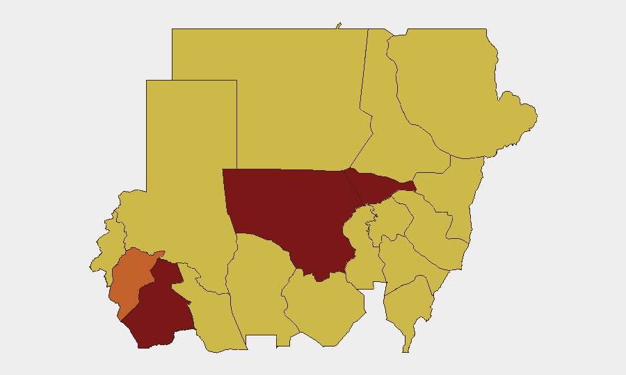
Situation Summary
Sudan remains in active civil conflict with a composite threat score of 100, driven primarily by ongoing armed clashes between state and non-state forces. The conflict has generated 54 tracked events in the GeoBit system, with recent signals indicating escalation in diplomatic tensions and military operations. The security environment remains highly volatile, with elevated risk concentrated in resource-rich northern and central regions where control over territory and resources is contested. Corporate presence in Sudan faces compounded exposure from both kinetic conflict and state actions against foreign nationals.
Key Developments
- 2026-06-16 · Diplomatic escalation: Sudan issued public statements and threats directed at Geneva and the United States, signaling potential friction with international bodies and foreign powers over intervention, sanctions, or ICC-related matters.
- 2026-06-14–15 · UK-Sudan tensions: Multiple incidents involving arrest/detention of UK nationals and two separate physical assault events recorded against British personnel or interests; conventional military force incidents also documented, indicating potential security sector involvement or state-directed action.
- 2026-06-13 · Administrative sanctions imposed: Sudan implemented domestic administrative sanctions, likely related to ongoing conflict or international pressure.
- 2026-06-13 · Internal and regional statements: Sudanese factions issued public statements against each other and against Eritrea, underscoring fragmentation and potential Eritrean involvement or cross-border spillover.
- RSF drone operations (June 14, unconfirmed): Single-source reports on social media indicate RSF drone strikes targeting El Obeid for the fifth consecutive day, along with village attacks in the Um area. *Note: This report lacks multi-source corroboration and should be monitored for confirmation.*
Highest-Risk Areas
North Kordofan State (risk 100) and Al Khartum (92.9) are the primary drivers of overall Sudan threat ranking, followed by South Darfur (91.2). These three areas represent zones of active combat, critical infrastructure exposure, and state security operations. North Kordofan's maximum risk score reflects ongoing RSF operations and resource competition; Al Khartum's elevated ranking reflects capital-city concentration of regime security forces, government targets, and foreign nationals. South Darfur and Central Darfur (75.3) continue to experience humanitarian and kinetic-conflict pressures. A secondary band of states—Blue Nile, River Nile, and eastern zones—registers at 70, indicating sustained militia activity and border volatility.
How GeoBit Would Assist
Security teams with people or assets in Sudan should activate Area-of-Interest Monitoring & Early Warning on high-risk state capitals and supply-route corridors to receive real-time alerting on military movements, checkpoints, and violence clusters. Conflict & Military mapping and force-structure tracking provide current visibility into RSF disposition, SAF unit locations, and militia presence by sub-national zone, enabling duty-of-care teams to anticipate displacement routes and safe corridors. Multi-language OSINT and X/Telegram intelligence with temporal and sentiment analysis will surface emerging threats—diplomatic, kinetic, or criminal—hours to days ahead of mainstream reporting.
7-Day Outlook
The diplomatic friction evident in recent statements to Geneva and Washington suggests potential escalation in international pressure or sanctions, which historically correlates with tightened regime security and increased harassment of foreign nationals. Continued RSF drone and ground operations in central states (El Obeid, Darfur) indicate sustained competition for territorial control and resources. Risk of secondary incidents against foreign personnel remains elevated given recent UK-Sudan confrontations; monitor for cascade effects on broader foreign-national access and movement in the capital and northern corridors.
Highest-Risk Areas — Ranked
| # | State / Region | Risk |
|---|---|---|
| 1 | North Kordofan State | 100 |
| 2 | Al Khartum | 92.9 |
| 3 | South Darfur State | 91.2 |
| 4 | Central Darfur State | 75.3 |
| 5 | Blue Nile | 70 |
| 6 | River Nile State | 70 |
| 7 | Aj Jazira | 70 |
| 8 | Red Sea State | 70 |
| 9 | Al Qadarif State | 70 |
| 10 | Kassala State | 70 |
| 11 | Sennar State | 70 |
| 12 | West Kurdufan State | 70 |
Sources
Previous Daily Briefs
A new Sudan brief is written every day — each with its own risk map and downloadable CSV. Here's the last week; use the calendar to go further back.
📅 Browse every day by calendar →
Highlighted days have a brief. Tap a day for that day's map & analysis, or “csv” for that day's dataset ($5).