Situation Summary
Suriname remains a low-to-moderate global security concern (rank #85, composite score 13) with no confirmed acute incidents in the past 24–48 hours. The country's security environment is characterized by chronic challenges in interior governance, border control, and organized-crime activity rather than imminent destabilization. Recent government and coast-guard statements and village-level disapproval signals suggest routine administrative or law-enforcement activity, though these merit continued monitoring for escalation.
Key Developments
- Nationwide — 11 July 2026 — Ministry forces conducted conventional military operation against organized-crime elements; no casualty or operational detail confirmed by independent sources.[1]
- Nationwide — 11 July 2026 — Head of state issued public statement to Surinamese population; content and audience scope unspecified in available reporting.[1]
- Coastal/Maritime — 11 July 2026 — Coast Guard initiated investigation; scope and location not yet detailed in open sources.[1]
- Village-level, location unspecified — 13 July 2026 — Local community expressed disapproval of representatives; no violence, disruption, or infrastructure impact reported.[1]
- Nationwide — 12 July 2026 — Government entity issued disapproval statement; specific target and rationale not yet clarified in available monitoring.[1]
- No confirmed new arrests, protests, clashes, or infrastructure failures reported in Paramaribo or the interior in the last 24–48 hours; petty theft, armed robbery, and vehicle theft remain chronic baseline risks in the capital.[3]
Highest-Risk Areas
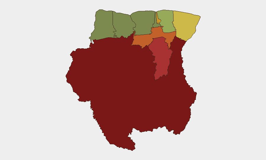
Sipaliwini (risk 92) and Brokopondo (risk 78) dominate sub-national risk, driven by weak state presence, transnational criminal networks, and illicit resource extraction in the interior and along border zones. Para (74) and Paramaribo (71) reflect organized-crime pressure and sporadic civil-order incidents in and around the capital. The eastern Marowijne district (68) faces chronic border-control and trafficking challenges. By contrast, western and northwestern regions (Coronie 12, Nickerie 8) show substantially lower threat profiles, reflecting lighter population density and reduced criminal activity.
How GeoBit Would Assist
Teams protecting personnel and assets in Suriname should employ GeoBit's AOI Monitoring & Early Warning capability to maintain persistent watch over Sipaliwini, Brokopondo, and Paramaribo for signs of organized-crime escalation or civil unrest, with automated alerting on protest activity and armed incidents. Intel Sweep and multi-language OSINT (X/Twitter, Telegram, local media) would track government statements, coast-guard operations, and localized disapproval signals in real time to distinguish routine enforcement from emerging instability. Routing & Network Analysis would enable alternative-route planning for personnel transiting the interior or coastal zones, accounting for piracy and roadblock risks in real time.
7-Day Outlook
Suriname's security trajectory over the next week is expected to remain broadly stable, with baseline organized-crime and petty-crime activity in Paramaribo and the interior persisting. The recent government and coast-guard actions suggest routine law-enforcement posture; without corroboration of escalation, no major incident or civil disorder is forecast. Duty-of-care teams should maintain standard precautions in Paramaribo and heightened vigilance in Sipaliwini and Brokopondo, while monitoring for any sign of political instability or transnational-crime surges.
Highest-Risk Areas — Ranked
| # | State / Region | Risk |
|---|---|---|
| 1 | Sipaliwini | 92 |
| 2 | Brokopondo | 78 |
| 3 | Para | 74 |
| 4 | Paramaribo | 71 |
| 5 | Marowijne | 68 |
| 6 | Commewijne | 42 |
| 7 | Wanica | 38 |
| 8 | Saramacca | 29 |
| 9 | Coronie | 12 |
| 10 | Nickerie | 8 |
Sources
Previous Daily Briefs
A new Suriname brief is written every day — each with its own risk map and downloadable CSV. Here's the last week; use the calendar to go further back.
📅 Browse every day by calendar →
Highlighted days have a brief. Tap a day for that day's map & analysis, or “csv” for that day's dataset ($5).
Atlas — our AI intelligence desk — emails them this snapshot personally. Nothing else, no list.