Situation Summary
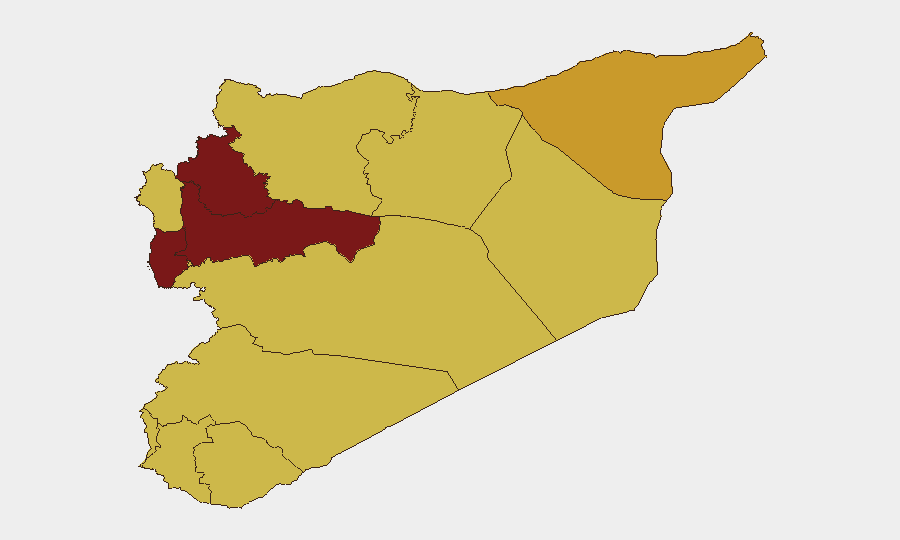
Syria remains the 11th-highest-threat country globally, driven by ongoing civil conflict and a composite threat score of 99 across 137 tracked events. The security environment has deteriorated over the past 48 hours, marked by attempted Islamic State operations in the northeast, internal armed clashes in the southwest, counter-terrorism sweeps by regime forces, and elevated regional geopolitical tensions. The northern and central governorates (Hama, Idleb, Tartus) continue to present the most acute risks, while ISIS activity in Raqqa and Druze armed tensions in As-Suwayda reflect fragmented control and persistent non-state actor presence across multiple theatres.
Key Developments
- Raqqa, Raqqa Governorate – 15 June 2026: Islamic State militants conducted an armed assault on a security facility in Raqqa city; Syrian Interior Ministry forces killed both attackers but sustained one fatality among their own personnel. Security alert levels have been raised nationwide at sensitive government and military installations.
- As-Suwayda city, As-Suwayda Governorate – 14–15 June 2026: Armed clashes between Druze-affiliated militia and Syrian General Security forces continued throughout the reporting period, with multiple gunfire exchanges and roadblocks established across the city. Active fighting persisted over at least a 48-hour window with no ceasefire reported.
- Damascus – 14–15 June 2026: Interior Ministry forces arrested Abdulilah Ismail Al‑Hamad, a former Al‑Quds Brigade commander, following an intelligence-led operation. The arrest follows accusations of war crimes, kidnapping, and narcotics trafficking, signalling ongoing internal security operations and potential tensions within regime security apparatus.
- National security posture – 15 June 2026: Syrian Interior Ministry announced heightened counter-terrorism alert status and reinforced security deployments at sensitive facilities nationwide in response to the Raqqa attack, elevating travel and operational risk around government, military, and critical infrastructure sites.
- UN and regional briefing – 14–15 June 2026: UN Secretary-General remarks flagged escalating attacks and deteriorating security dynamics in the broader Middle East region, with Syria explicitly cited as an area at risk of renewed conflict escalation.
- Iraq–Syria border zone – 15 June 2026: Combined Joint Task Force–OIR (Counter-ISIS Coalition) issued a public statement reaffirming close monitoring of Syrian developments and continued counter-ISIS operations along the Iraq–Syria nexus, indicating sustained cross-border military activity and heightened intelligence collection.
Highest-Risk Areas
Hama, Idleb, and Tartus governorates dominate the risk landscape, with composite scores exceeding 91. These northern and central regions remain theatres of active armed conflict, militia fragmentation, and contested territorial control. Damascus Governorate, despite nominal regime control, scores 88.3 due to ongoing internal security operations, arrest sweeps, and proximity to armed group activity. The remaining governorates (Al-Hasaka, Aleppo, Lattakia, Al-Quneitra, Dar'a, Ar-Raqqa, Homs) cluster in the 68.9–71.4 range, reflecting widespread ISIS cells, armed factions, and checkpoint proliferation affecting movement and personnel safety across the country.
How GeoBit Would Assist
Corporate teams would employ AOI Monitoring & Early Warning to track Hama, Idleb, and Raqqa for renewed ISIS or militia activity; Intel Sweep and OSINT fusion (Twitter, Telegram, local reporting) to detect armed group movements and checkpoint expansion in real time; and Routing & Network Analysis to identify secure transit corridors and alternate supply/evacuation paths. Conflict & Military force-structure tracking and satellite imagery analysis provide situational awareness of armed positions and regime deployments affecting asset locations.
7-Day Outlook
ISIS opportunism in Raqqa is likely to persist given the governorate's historical role as a base; regime counter-terrorism sweeps will remain elevated, increasing checkpoint density and detention risk. Druze–regime tensions in As-Suwayda may escalate or stabilize depending on negotiation outcomes; parallel friction in northern governorates suggests a volatile near-term environment with limited de-escalation signals. Personnel and asset risk remains acute across all northern and eastern zones.
Highest-Risk Areas — Ranked
| # | State / Region | Risk |
|---|---|---|
| 1 | Hama Governorate | 98.9 |
| 2 | Idleb Governorate | 94.6 |
| 3 | Tartus Governorate | 91.4 |
| 4 | Damascus Governorate | 88.3 |
| 5 | Al-Hasaka Governorate | 71.4 |
| 6 | Aleppo Governorate | 69.6 |
| 7 | Lattakia Governorate | 68.9 |
| 8 | UNDOF | 68.9 |
| 9 | Al-Quneitra Governorate | 68.9 |
| 10 | Dar'a Governorate | 68.9 |
| 11 | Ar-Raqqa Governorate | 68.9 |
| 12 | Homs Governorate | 68.9 |
Sources
Previous Daily Briefs
A new Syria brief is written every day — each with its own risk map and downloadable CSV. Here's the last week; use the calendar to go further back.
📅 Browse every day by calendar →
Highlighted days have a brief. Tap a day for that day's map & analysis, or “csv” for that day's dataset ($5).