Situation Summary
Tajikistan's overall security environment remains stable, with no verified reports of terrorism, major violence, or civil unrest in the last 24–48 hours. The primary near-term threat is natural hazard–related: a government-issued mudflow and landslide warning for 19–22 June affects mountainous regions nationwide, creating travel and infrastructure disruption risks. Diplomatic activity (Georgian PM visit, OSCE border-stability talks, Iran–Tajikistan security coordination) reflects routine regional engagement rather than response to acute crisis, suggesting no imminent political or security escalation.
Key Developments
- Nationwide (mountainous regions) – 19 June 2026 – Mudflow and landslide warning issued. The Tajik Hydrometeorology Agency and Emergency Situations Committee issued a government alert for 19–22 June, citing high temperatures and snowmelt as triggers for mudflows in foothill and mountain areas. Risk extends to roads, villages, and river-valley infrastructure.
- Dushanbe and inter-regional highways – 19–20 June 2026 – Travel disruption advisory in effect. Local media reports explicitly warn drivers and residents on main corridors and mountain passes of potential washouts and road blockages linked to the mudflow alert, with no specific closures confirmed as of 20 June.
- Dushanbe – 18 June 2026 – Deputy Foreign Minister meets OSCE Special Representative. Idibek Kalandar discussed regional security, border stability, and transnational-threat cooperation; no new incident or escalation reported in connection with the meeting.
- Dushanbe – 19–20 June 2026 – Georgian Prime Minister official visit. Irakli Kobakhidze met President Rahmon; communiqué emphasizes political, economic, transport, and security cooperation without citing any domestic instability.
- Dushanbe–Tehran diplomatic axis – 19 June 2026 – Iran reaffirms security and counterterrorism cooperation with Tajikistan. Iranian leadership publicly praised Tajik support and called for closer coordination on regional security; no new specific incident prompted the statement.
- Seismic activity – recent – M 4.2 earthquake 63 km east of Khorugh, Gorno-Badakhshan. A moderate seismic event was recorded in the highest-risk sub-national zone; no immediate casualty or damage reports available.
Highest-Risk Areas
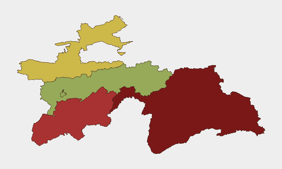
Gorno-Badakhshan Autonomous Region (risk 92) remains the dominant driver of national risk, reflecting its remote terrain, limited state presence, cross-border trafficking, and seismic hazards. Khatlon Region (78) and Sughd Region (65) follow, with risk linked to historic border tensions, smuggling networks, and drug-transit activity. Dushanbe (42), despite being the capital, ranks significantly lower, reflecting stronger state security apparatus and urban governance. All three high-risk regions are vulnerable to natural hazards (mudflows, earthquakes, avalanches) compounding political and criminal risk.
How GeoBit Would Assist
Security teams would deploy AOI Monitoring & Early Warning on Gorno-Badakhshan and Khatlon to detect emerging trafficking, militant, or cross-border activity before escalation. Environmental & Health monitoring and GIS & Spatial Analysis would track mudflow risk, road conditions, and infrastructure vulnerability in real time, enabling duty-of-care teams to adjust travel and logistics. Network & Actor Analysis combined with multi-language OSINT would maintain visibility into border-zone criminal and extremist networks that operate across Tajikistan's porous frontiers.
7-Day Outlook
The mudflow alert (19–22 June) will likely create 3–5 days of localized travel delays and possible short-term road closures in mountain regions; conditions should normalize by 22–23 June pending weather patterns. No escalation in political violence or border incidents is anticipated based on current diplomatic posture and absence of triggering events. Risk remains primarily environmental and logistical rather than security-incident-driven.
Highest-Risk Areas — Ranked
| # | State / Region | Risk |
|---|---|---|
| 1 | Gorno-Badakhshan Autonomous Region | 92 |
| 2 | Khatlon Region | 78 |
| 3 | Sughd Region | 65 |
| 4 | Districts of Republican Subordination | 58 |
| 5 | Dushanbe | 42 |
Sources
Previous Daily Briefs
A new Tajikistan brief is written every day — each with its own risk map and downloadable CSV. Here's the last week; use the calendar to go further back.
📅 Browse every day by calendar →
Highlighted days have a brief. Tap a day for that day's map & analysis, or “csv” for that day's dataset ($5).