Situation Summary
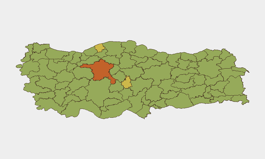
Turkey remains at composite threat rank #32 globally with 313 tracked events, reflecting a complex security environment marked by diplomatic tensions, counter-terrorism operations, and governance scrutiny. Recent signals point to NATO-related friction, international disapproval on unspecified matters, and elevated investigative activity by Turkish authorities. Ankara's risk score (73.3) significantly outpaces other regions, suggesting concentration of political and security volatility in the capital and its immediate vicinity.
Key Developments
Limitation on Live Coverage: GeoBit's live web research has not identified time-verified discrete incidents from the last 24–48 hours (June 24–25, 2026) with sufficient specificity for operational briefing. Signal data show six public statements and two investigations by Turkish authorities (June 25), two disapproval events (June 24–25), and cross-border tensions with Australia and South Korea (June 23), but underlying incident details, locations, and current status remain unconfirmed. UK FCDO advisory (updated to June 25) confirms Ankara will host road closures and heightened security 7–8 July for NATO summit; no imminent closures or blockages reported for the current 24–48h window. Administrative sanctions imposed by Turkey against Tehran (June 23) reflect escalating Iran–Turkey tensions, though operational impact on foreign nationals remains unclear. Pending confirmation of specific trigger events from wire services and Turkish state media (Anadolu Agency), advisory caution is warranted pending further corroboration.
Highest-Risk Areas
Ankara (73.3) is the dominant risk driver, reflecting its status as the political and administrative hub where diplomatic incidents, security operations, and government oversight cluster. Bartın (67.6), Nevşehir (63.6), and Izmir (57.5) form a secondary tier; their elevated scores likely correlate with industrial/infrastructure sensitivity, tourism density, or proximity to geopolitical flashpoints. Istanbul (50.1), while lower-ranked, remains operationally significant for foreign businesses and expatriate populations; its lower composite score may reflect distributed risk rather than absence of threat. Southeast border provinces (Şırnak, Hakkâri, Kars) remain stable in the 43–44 range, consistent with chronic PKK-linked activity and border friction but not showing acute escalation signals.
How GeoBit Would Assist
Intel Sweep & OSINT Fusion would corroborate the June 23–25 signal events with Turkish-language media, wire feeds, and Telegram OSINT to extract specific incident locations, casualties, and official statements. AOI Monitoring & Early Warning on Ankara, Istanbul, and border provinces would detect emerging protests, security operations, or diplomatic closures in near-real time and alert duty teams to route/travel impacts. Network & Actor Analysis would map relationships between Turkish state entities, NATO, and international actors to contextualize disapproval and demand signals and assess reputational or sanctions risk to corporate operations.
7-Day Outlook
The NATO summit (7–8 July) will dominate Ankara's security posture; road closures, checkpoint increases, and protest activity are probable. Pending resolution of current investigations and public statements (June 25), expect either de-escalation or further international criticism and possible secondary sanctions. Foreign nationals and assets in Ankara should prepare for mobility constraints and heightened screening; those in Istanbul and Izmir face lower acute risk but should monitor for solidarity protests or supply-chain disruptions.
Highest-Risk Areas — Ranked
| # | State / Region | Risk |
|---|---|---|
| 1 | Ankara | 73.3 |
| 2 | Bartın | 67.6 |
| 3 | Nevşehir | 63.6 |
| 4 | Izmir | 57.5 |
| 5 | Istanbul | 50.1 |
| 6 | Canakkale | 44.7 |
| 7 | Erzurum | 44 |
| 8 | Şırnak | 44 |
| 9 | Hakkâri | 44 |
| 10 | Kars | 43.3 |
| 11 | Yozgat | 43.3 |
| 12 | Niğde | 43.3 |
Sources
Previous Daily Briefs
A new Turkey brief is written every day — each with its own risk map and downloadable CSV. Here's the last week; use the calendar to go further back.
📅 Browse every day by calendar →
Highlighted days have a brief. Tap a day for that day's map & analysis, or “csv” for that day's dataset ($5).