Situation Summary
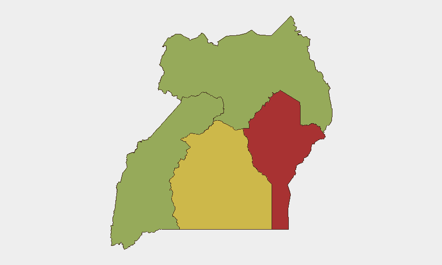
Uganda remains in the middle range of global security concern (rank #26, composite score 71), with a volatile security environment driven by concurrent political unrest, border-security coordination, and ongoing public-health measures related to the Bundibugyo-virus Ebola outbreak. Nationwide anti-government protests and activist detentions occurred on 25 July, while security-force responses have included crowd dispersal and arrests. The Eastern Region carries the highest sub-national risk (79.6), followed by Central and Northern regions; near-term trajectory suggests continued political tension and elevated police activity, with border-security upgrades likely to reduce cross-border threats in the north.
Key Developments
- Kisekka Market, Kampala Central Division – 2026-07-20 (confirmed via police statement within last 48h)
Armed on-duty security officers discharged weapons into the air to disperse a crowd attempting to block the arrest of two suspects; situation was brought under control and arrests completed. Video circulated on social media; police have now officially confirmed the incident and context.
- Nationwide (Kampala, universities, multiple cities) – 2026-07-25
Concurrent anti-government protest rallies and activist detentions reported across multiple sites, including demonstrations against Parliament; security forces dispersed gatherings and arrested participants. Precise casualty figures and all specific locations remain unconfirmed, but events are confirmed as same-day, nationwide political-unrest activity.
- Arua District, Uganda–South Sudan frontier – 2026-07-24
Ugandan and South Sudanese officials reactivated joint border-security committees to address cross-border banditry, migration, and refugee management; signals stepped-up bilateral coordination along northern Uganda's border in the immediate term.
- Nationwide travel and entry screening – status reaffirmed through 2026-07-26
Enhanced screening and surveillance measures remain in effect for travelers from Uganda in response to the ongoing Bundibugyo-virus Ebola outbreak affecting DRC and Uganda; Uganda's last confirmed case was 21 June, but international health protocols and airport controls have been reaffirmed in late-July updates.
Highest-Risk Areas
The Eastern Region dominates the sub-national risk profile (79.6), likely driven by ongoing criminal and militia activity, weak state capacity, and cross-border flows from Kenya and South Sudan. The Central Region (60.8)—encompassing Kampala and surrounding districts—carries elevated risk due to concentrated political activity, law-enforcement operations, and density of potential protest and unrest sites. Northern and Western regions (55.8 and 53.5 respectively) remain at moderate-to-high risk, with the north increasingly stabilized by enhanced bilateral border-security coordination but still vulnerable to transnational banditry and militia spillover.
How GeoBit Would Assist
Security teams operating in Uganda should employ AOI Monitoring & Early Warning to track political and law-enforcement activity in Kampala, Central Region, and border zones, with customized alerting for arrests, protests, and military movements. Intel Sweep and multi-language OSINT fusion capabilities enable continuous corroboration of incident reports across social media, local news, and security-force statements, reducing exposure to unverified rumors. Regime-stability and conflict search functions, combined with Network & Actor Analysis, help teams understand the organizations and actors driving recent unrest and anticipate follow-on activity.
7-Day Outlook
Political tension is likely to remain elevated over the next week, with potential for additional protest activity and security-force responses, particularly in Kampala and university centers. Border-security upgrades in the north should reduce acute banditry and infiltration risks; however, Central and Eastern regions will continue to warrant close monitoring for activist detention, protest escalation, and any spillover of instability from neighboring districts.
Highest-Risk Areas — Ranked
| # | State / Region | Risk |
|---|---|---|
| 1 | Eastern Region | 79.6 |
| 2 | Central Region | 60.8 |
| 3 | Northern Region | 55.8 |
| 4 | Western Region | 53.5 |
Sources
Previous Daily Briefs
A new Uganda brief is written every day — each with its own risk map and downloadable CSV. Here's the last week; use the calendar to go further back.
📅 Browse every day by calendar →
Highlighted days have a brief. Tap a day for that day's map & analysis, or “csv” for that day's dataset ($5).
Atlas — our AI intelligence desk — emails them this snapshot personally. Nothing else, no list.