Situation Summary
Ukraine remains under sustained high-intensity Russian attack as of 13 June 2026, with overnight air strikes on 11–12 June killing civilians and targeting energy infrastructure across multiple regions. Large-scale drone and missile assaults (221 drones and 2 ballistic missiles in the most recent 24-hour cycle) continue despite Ukrainian air-defense efforts, while frontline combat intensity has risen sharply with over 180 engagements reported in a single 24-hour period. Ukrainian territorial gains near Oleksandrivka and broader reclamation of ~600 km² this year suggest tactical momentum in select sectors, but the frequency and scale of Russian strikes indicate no near-term reduction in kinetic threat. Escalatory rhetoric from Moscow (including renewed nuclear-capability statements on 11 June) adds strategic-risk dimension to the operational picture.
Key Developments
- Kharkiv city and region (night of 11–12 June 2026): Russian drone and missile strikes killed at least three civilians, including a pregnant woman, with additional injuries reported. Strikes targeted populated areas and infrastructure.
- Nationwide air attack (night of 11–12 June 2026): Russian forces deployed 221 drones and 2 Iskander-M ballistic missiles; Ukrainian air defense intercepted most, though some struck energy and urban infrastructure across the country.
- Oleksandrivka, Donetsk region (11 June 2026): Ukrainian forces advanced near Oleksandrivka in recent fighting, reclaiming territory on the eastern front amid intensified combat reported by Ukrainian commanders and independent military monitors.
- Frontline engagement surge (10–11 June 2026): Ukrainian military recorded over 180 frontline engagements within 24 hours across Zaporizhzhia, Donetsk, and other sectors, indicating sustained high-intensity combat and elevated risk near contact lines.
- Russian strategic escalation (11 June 2026): Russia's deputy foreign minister publicly restated readiness to deploy "all means, including nuclear ones," signaling continued strategic-risk posture and escalation concerns.
- Ukrainian unmanned-systems doctrine (11 June 2026): President Zelenskyy signed a decree formalizing "Day of the Unmanned Systems Forces," institutionalizing drone-centric defense operations as a core component of Ukrainian military strategy.
Highest-Risk Areas
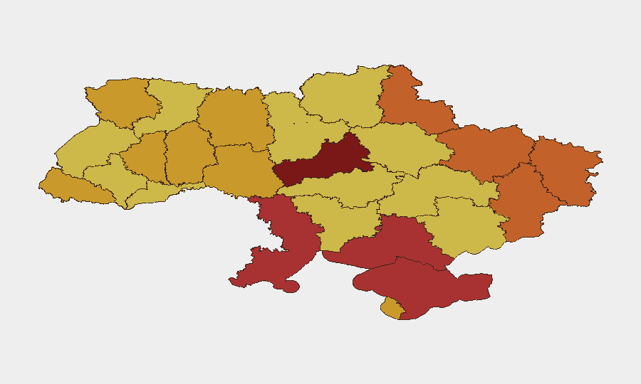
Cherkasy Oblast and Kyiv (composite risk scores 100 and 95.3, respectively) dominate the threat landscape, driven by proximity to active frontlines, Russian air-strike capability, and concentration of national critical infrastructure and civilian population. Kherson, Kharkiv, Donetsk, and Sumy oblasts form a secondary tier of extreme risk (scores 73–78.1), reflecting both conventional military activity and air-strike exposure. The overnight strikes on Kharkiv and nationwide drone assaults underscore that no region is insulated from aerial threat; even western and central oblasts (Vinnytsia, Zhytomyr, Volyn) face significant residual risk from deep-strike operations.
How GeoBit Would Assist
Security teams would deploy AOI Monitoring & Early Warning on corporate facilities and personnel clusters in high-risk oblasts (Kyiv, Kharkiv, Cherkasy) to receive real-time alerts on drone/missile activity and air-raid warnings. Conflict & Military mapping and force-structure tracking enable duty-of-care teams to anticipate frontline shifts and route-planning impacts. OSINT fusion and multi-language Telegram/X monitoring provide 4–6 hour advance notice of escalatory statements or targeting patterns before kinetic strikes materialize.
7-Day Outlook
Russian air-strike tempo is likely to remain elevated through mid-to-late June given demonstrated drone and missile availability and stated strategic intent. Ukrainian territorial advances and drone-logistics disruption may trigger further Russian retaliation against urban centers and energy systems. Personnel and asset managers should expect continued volatility in Kyiv, Kharkiv, and frontline-adjacent regions with intermittent transportation and utilities disruption.
Highest-Risk Areas — Ranked
| # | State / Region | Risk |
|---|---|---|
| 1 | Cherkasy Oblast | 100 |
| 2 | Kyiv | 95.3 |
| 3 | Autonomous Republic of Crimea | 79 |
| 4 | Kherson Oblast | 78.1 |
| 5 | Odesa Oblast | 76.1 |
| 6 | Kharkiv Oblast | 75.6 |
| 7 | Sumy Oblast | 74.9 |
| 8 | Donetsk Oblast | 74 |
| 9 | Luhansk Oblast | 73 |
| 10 | Volyn Oblast | 72.1 |
| 11 | Zhytomyr Oblast | 71.9 |
| 12 | Vinnytsia Oblast | 71.3 |
Sources
Previous Daily Briefs
A new Ukraine brief is written every day — each with its own risk map and downloadable CSV. Here's the last week; use the calendar to go further back.
📅 Browse every day by calendar →
Highlighted days have a brief. Tap a day for that day's map & analysis, or “csv” for that day's dataset ($5).