Situation Summary
Uruguay maintains a stable operating environment with no confirmed security incidents, civil unrest, or infrastructure disruptions reported in the last 24–48 hours. The country's composite threat score of 14 places it among the lowest-risk jurisdictions globally. However, concentrated crime and gang activity in Montevideo and surrounding departments (Canelones, Maldonado) create localized elevated risk zones that warrant ongoing monitoring, particularly for organizations with personnel or assets in those areas.
Key Developments
- Montevideo — June 22–23 — Presidential and ministerial public statements issued; a judicial statement on June 23 indicates policy or administrative action, though specific content and implications remain unconfirmed in available open sources.
- National level — June 22–23 — Two separate expressions of disapproval recorded at state level; nature and context unclear from available signals.
- Regional (gang activity, Brazil border) — June 21 — Gang-related public statement flagged near Brazil border; no direct threat to Uruguay's interior confirmed, but consistent with known cross-border smuggling and trafficking networks.
- International diplomatic signal — June 23 — France issued disapproval statement; likely unrelated to internal Uruguay security but may reflect broader regional diplomatic friction.
- No domestic incidents — Last 24–48 hours — No confirmed reports of armed confrontation, kidnapping, extortion targeting international business, or significant criminal activity within Uruguay proper.
Highest-Risk Areas
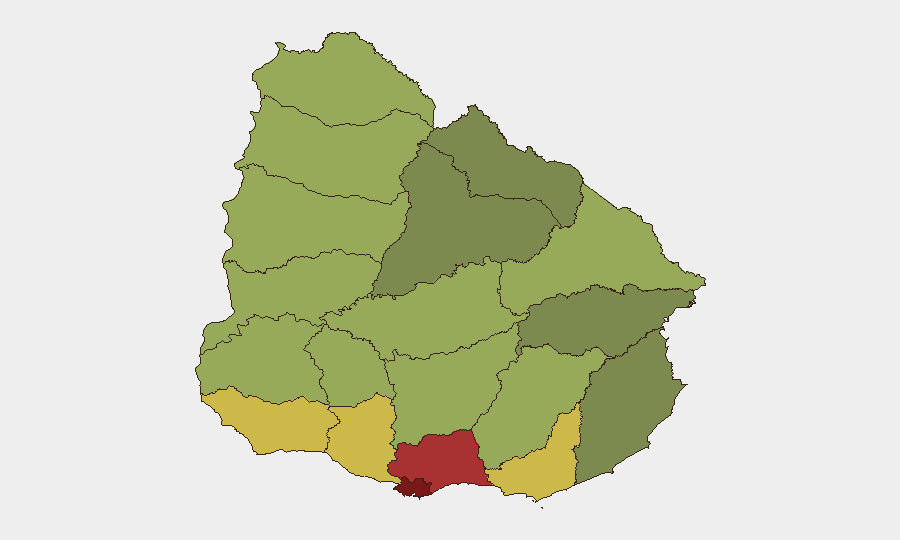
Montevideo (risk score 92) and its immediate hinterland—Canelones (78) and Maldonado (68)—account for the majority of tracked threat signals. These departments are home to organized gang networks, drug-trafficking corridors, and property crime; Montevideo's urban density and port infrastructure amplify exposure. Secondary risk concentrations in San José, Colonia, and Soriano (scores 64, 62, 58) suggest gang activity radiates inland along trafficking routes. Northern border departments (Artigas, Salto, Paysandú, Río Negro) register lower but persistent scores, consistent with known narcotics transit activity. Organizations concentrated in central and southern Montevideo should prioritize physical-security protocols and situational awareness; those in rural or northern regions face marginally lower acute risk.
How GeoBit Would Assist
Teams should deploy AOI Monitoring & Early Warning on Montevideo and Canelones to detect spikes in gang signaling, criminal enterprise public statements, or infrastructure-targeting activity before operational impact. Intel Sweep and multi-language OSINT fusion (X/Telegram, news feeds) will corroborate official reports and surface emerging threat narratives missed by traditional media. Network & Actor Analysis can map gang hierarchies and trafficking nodes to assess whether heightened diplomatic or state-level activity signals pressure on criminal operations. For duty-of-care teams, Routing & Network Analysis supports real-time journey planning around high-risk zones in Montevideo and port areas during periods of elevated gang tension.
7-Day Outlook
No imminent escalation in Uruguay's internal security environment is indicated. The current diplomatic and administrative statements may reflect routine policy adjustments or regional posturing unrelated to domestic stability. Organizations should maintain standard operating procedures while monitoring June 23–30 for follow-on state actions that might signal changed enforcement posture toward organized crime or trafficking networks in Montevideo and northern departments.
Highest-Risk Areas — Ranked
| # | State / Region | Risk |
|---|---|---|
| 1 | Montevideo | 92 |
| 2 | Canelones | 78 |
| 3 | Maldonado | 68 |
| 4 | San José | 64 |
| 5 | Colonia | 62 |
| 6 | Soriano | 58 |
| 7 | Río Negro | 56 |
| 8 | Salto | 54 |
| 9 | Artigas | 52 |
| 10 | Paysandú | 50 |
| 11 | Florida | 48 |
| 12 | Flores | 46 |
Previous Daily Briefs
A new Uruguay brief is written every day — each with its own risk map and downloadable CSV. Here's the last week; use the calendar to go further back.
📅 Browse every day by calendar →
Highlighted days have a brief. Tap a day for that day's map & analysis, or “csv” for that day's dataset ($5).