Situation Summary
Venezuela remains at composite threat rank #36 globally, with a critical acute security layer added by major seismic activity and cascading humanitarian/infrastructure collapse since 24 June. A 7.5 magnitude earthquake west of Caracas, followed by significant aftershocks, has triggered a nationwide state of emergency, widespread infrastructure damage, confirmed casualties (estimates range above 900), airport closures, and transport disruption. This natural disaster is compounding existing fragmentation across law enforcement, political instability (reflected in recent arrests and authority statements), and elevated civil unrest—creating a convergence of natural-disaster risk and pre-existing political-security tensions that materially increases duty-of-care exposure for personnel and assets in-country.
Key Developments
- West of Caracas, 24 June: 7.5 magnitude earthquake caused major infrastructure damage in Caracas and surrounding areas, with confirmed injuries and reports of 900+ casualties. Follow-on aftershocks recorded through 27 June.
- Nationwide, 24–27 June: State of emergency declared; airports reported closed or severely restricted; transport networks disrupted across multiple states, particularly affecting access to/from Caracas and coastal regions.
- Caracas & Federal District, 27 June: Violent protest/riot documented in relation to post-earthquake response or resource distribution; concurrently, politician arrested on unspecified charges involving citizen relations (context unclear but timing suggests emergency-response-related tension).
- Caracas/Authority Level, 27 June: Public statement from authorities responding to representatives regarding emergency measures; separate statement from unnamed scientist (content/discipline unconfirmed in available data).
- Barquisimeto (Lara State), 26 June: Property seizure/damage incident reported; unclear if earthquake-related or distinct security event.
- Colombia–Venezuela Border, 26 June: Conventional military force activity documented; nature and scale unconfirmed, but timing aligns with broader instability window.
- Caracas & Travel Advisories, 25–27 June: Canada escalated to "avoid all travel"; Australia maintained "do not travel" advisory, citing heightened security, consular risk, and disrupted services post-emergency.
Highest-Risk Areas
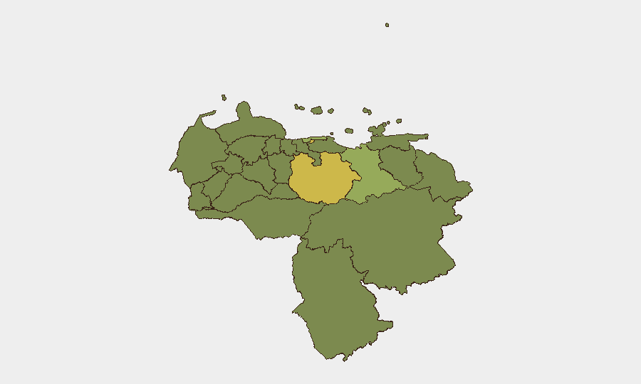
Federal District (Caracas area; risk 63.5) now serves as the epicenter of both earthquake impact and cascading civil/political friction—airport closures, damage, and emergency response bottlenecks are concentrating risk. Guarico State (60.2) shows elevated baseline threat independent of earthquake activity, suggesting persistent criminal or organizational instability. Vargas, Anzoategui, and Carabobo states (47.1–44.4) form a secondary band of elevated risk, reflecting a combination of gang activity, resource-scarcity tensions, and (for Vargas) proximity to Caracas spillover effects. The earthquake has likely compressed response capacity and visibility across all states, increasing operational blind spots for corporate security teams.
How GeoBit Would Assist
Intel Sweep + AOI Monitoring: Continuous multi-language OSINT (X, local radio, government statements, humanitarian channels) across Federal District, Guarico, and coastal states to track emergency-response breakdowns, civil unrest, and authority statements in near-real time. Conflict & Military + Network Analysis: Monitoring of military/security-force positioning, road blocks, and armed-group activity in high-risk states, combined with entity extraction of named officials/commanders to assess command-and-control coherence during crisis. Routing & Network Analysis + GIS: Alternative journey planning and persistent area-of-interest alerting for personnel and asset movement, accounting for earthquake damage, road closures, and emerging security incidents.
7-Day Outlook
Immediate near-term risk trajectory is upward: emergency-response capacity strain, resource competition, and political tensions are likely to fuel localized civil unrest and opportunistic security incidents across 24–72 hours. By day 5–7, stabilization of transport corridors and authority reassertion may reduce acute acute risk, but underlying political fragmentation and post-disaster resource scarcity will sustain elevated baseline threat through early July. Organizations with personnel in Federal District or Guarico should implement heightened duty-of-care protocols and evacuation readiness.
Highest-Risk Areas — Ranked
| # | State / Region | Risk |
|---|---|---|
| 1 | Federal District | 63.5 |
| 2 | Guarico State | 60.2 |
| 3 | Vargas State | 47.1 |
| 4 | Anzoategui State | 44.4 |
| 5 | Carabobo State | 39.7 |
| 6 | Amazonas State | 35.8 |
| 7 | Barinas State | 34.6 |
| 8 | Lara State | 34.5 |
| 9 | Miranda State | 34.3 |
| 10 | Aragua State | 34.1 |
| 11 | Trujillo State | 33.8 |
| 12 | Tachira State | 33.8 |
Sources
Previous Daily Briefs
A new Venezuela brief is written every day — each with its own risk map and downloadable CSV. Here's the last week; use the calendar to go further back.
📅 Browse every day by calendar →
Highlighted days have a brief. Tap a day for that day's map & analysis, or “csv” for that day's dataset ($5).