Situation Summary
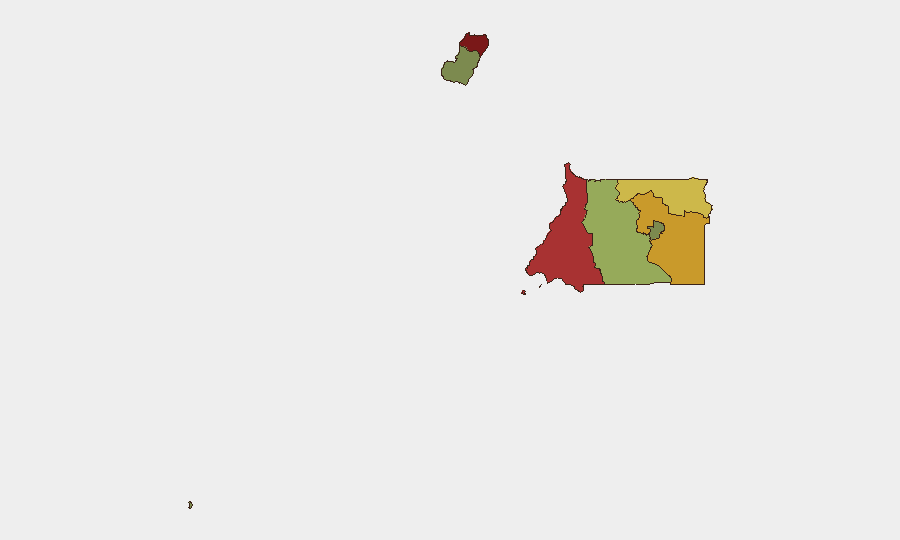
Equatorial Guinea remains a low-threat environment globally (rank 143, composite score 11) with no confirmed security incidents recorded in the monitoring period. Governance and infrastructure challenges—particularly electricity supply and hydrocarbon sector uncertainty—dominate near-term administrative focus. The sub-national threat landscape is concentrated in the northern and coastal provinces, with Bioko Norte (risk 85) and Litoral Province (risk 78) substantially outpacing other regions; southern and island areas pose minimal risk. Overall trajectory remains stable absent external shocks.
Key Developments
- Malabo — 14 October: Vice President Teodoro Nguema Obiang Mangue directed the Ministry of Electricity to present a management plan for state utility SEGESA within seven days, following a ministerial review that identified unpaid supplier bills, missing spare parts, and recurring electrical faults. This signals administrative pressure on critical infrastructure performance.
- Bata and Annobón — 14 October: Health authorities commenced a door-to-door campaign to distribute over 500,000 insecticide-treated mosquito nets across mainland and island regions, indicating operational capacity for large-scale public-health coordination.
- Equatorial Guinea — 16 October: The government announced approval of a new hydrocarbons law (scheduled for the following Monday) designed to offer more competitive terms to oil explorers, reflecting concern over declining national oil output and fiscal revenue.
- Equatorial Guinea — 17 October: U.S. deportee Ahmed Soliman was reported hospitalized with a serious unspecified illness; U.S. officials continued efforts to locate and facilitate his return under a federal court order, highlighting potential consular and duty-of-care complications for U.S. nationals.
- Background context (8 October): A fire at Nkoa Ntoma military camp allegedly ignited by farmers clearing fields spread to poorly stored explosives, triggering multiple detonations. This incident—the most recent confirmed security event in GeoBit records—underscores gaps in military facility perimeter management and hazardous-materials storage protocols in the country's security infrastructure.
Highest-Risk Areas
Bioko Norte and Litoral Province together account for the majority of sub-national threat concentration (composite risks 85 and 78 respectively). Both regions host critical infrastructure (ports, energy facilities, government centers in Malabo and Bata), international commerce, and higher population density, creating expanded vectors for operational disruption. Wele-Nzas Province (risk 72) and Kié-Ntem Province (risk 68) follow, likely reflecting cross-border dynamics and limited state capacity in the interior. Southern and island provinces (Bioko Sur, Centro Sur, Annobón) present significantly lower risk profiles and remain suitable for standard security postures.
How GeoBit Would Assist
Corporate teams with operations in Equatorial Guinea should employ AOI Monitoring & Early Warning focused on Bioko Norte and Litoral Province to detect infrastructure disruptions, political instability signals, or cross-border incursions in real time. Intel Sweep and multi-language OSINT (including X/Twitter and Telegram intelligence) enable continuous tracking of regime-stability indicators, utility sector developments, and labor/civil unrest signals that could affect duty-of-care obligations. Routing & Network Analysis supports contingency planning for personnel evacuation or asset repositioning should instability escalate in northern provinces.
7-Day Outlook
No imminent security deterioration is forecast for the next seven days. Administrative focus will likely remain on hydrocarbon-law implementation and electricity-sector reforms. Monitoring should continue for any labor disputes, cross-border activity spillover from neighboring Cameroon or Gabon, or unexpected political signals from the Vice President's infrastructure directives.
Highest-Risk Areas — Ranked
| # | State / Region | Risk |
|---|---|---|
| 1 | Bioko Norte | 85 |
| 2 | Litoral Province | 78 |
| 3 | Wele-Nzas Province | 72 |
| 4 | Kié-Ntem Province | 68 |
| 5 | Centro Sur Province | 45 |
| 6 | Bioko Sur | 38 |
| 7 | Djibloho | 15 |
| 8 | Annobón Province | 8 |
Sources
Previous Weekly Briefs
A new Equatorial Guinea brief is written every Monday, covering the week — each with its own risk map and downloadable CSV. Use the calendar to go further back.
- October 13, 2026
- October 6, 2026
- September 29, 2026
- September 22, 2026
- September 15, 2026
- September 8, 2026
- September 1, 2026
📅 Browse past briefs by calendar →
Highlighted days have a brief. Tap a day for that day's map & analysis, or “csv” for that day's dataset ($5).
Atlas — our AI intelligence desk — emails them this snapshot personally. Nothing else, no list.