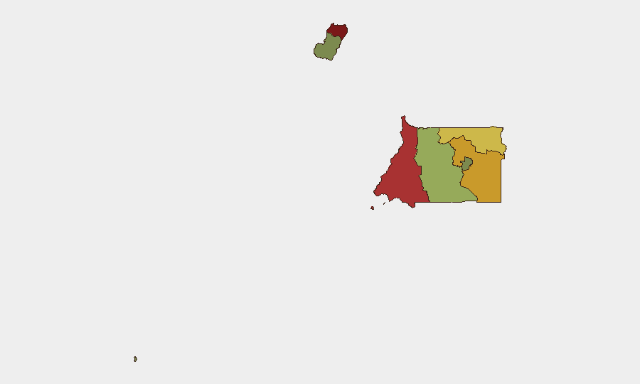
Situation Summary
Equatorial Guinea remains in a generally calm security environment with no confirmed acute incidents in the last 24–48 hours. The country presents a composite threat score of 4 globally and ranks outside the top incident-reporting zones for West and Central Africa. While sub-national risk concentrations exist in Bioko Norte and Litoral Province, the absence of active conflict, organized unrest, or major crime events in the current window indicates stability and routine governance operations.
Key Developments
- No discrete security, civil unrest, or infrastructure incidents confirmed in Equatorial Guinea during 21–22 July 2026. Open-source incident feeds, regional news streams, and social media monitoring yield no corroborated reports of attacks, protests, criminal events, or service disruptions in the last 24–48 hours.
- Malabo – International air-services event scheduled. ICAO confirmed Equatorial Guinea will host the 2026 ICAN air-services negotiation event in December 2026, indicating normal diplomatic and aviation engagement with no associated security alerts reported.
- Washington, D.C. – Routine U.S. diplomatic appointment under review. The U.S. Senate Foreign Relations Committee has scheduled a confirmation vote for Stanley Brown as U.S. ambassador to Equatorial Guinea (expected 22 July 2026), reflecting standard bilateral relations and no response to emerging crises.
- Regional context – Equatorial Guinea absent from active Central African security reporting. Concurrent security incidents and unrest in neighboring Cameroon, Guinea, and Guinea-Bissau do not extend to or implicate Equatorial Guinea in available reporting.
Highest-Risk Areas
Bioko Norte (risk 85) and Litoral Province (risk 78) drive the sub-national risk profile, likely reflecting population density, port and border-transit activity, and historical vulnerability to transnational organized crime and small-scale unrest. Wele-Nzas Province (72) and Kié-Ntem (68) follow, suggesting border-zone dynamics and resource-extraction pressures. These concentrations warrant monitoring but do not currently reflect active acute incidents; rather, they represent structural risk factors (geography, economic activity, governance capacity) that require persistent watch rather than emergency response.
How GeoBit Would Assist
Security teams operating in Equatorial Guinea should deploy AOI (Area of Interest) Monitoring & Early Warning on Bioko Norte, Litoral, and key border crossings to detect emerging protests, movements, or criminal activity before mainstream reporting. OSINT fusion across X/Twitter, Telegram, local radio SIGINT, and YouTube content in Spanish and Portuguese would provide 24–7 ground-truth signals ahead of formal news cycles. Entity extraction and network analysis of transport, port, and cross-border movement data would map trafficking and organized-crime patterns relevant to asset protection and duty-of-care compliance.
7-Day Outlook
No acute threat trajectory change is anticipated over the next 7 days based on current open-source indicators and diplomatic calendar. Continued routine operations, planned ICAO engagement, and absence of triggering political or economic shocks suggest stability will hold through late July 2026. Persistent sub-national risks in northern provinces and coastal zones remain structural and warrant ongoing monitoring, but do not signal imminent escalation.
Highest-Risk Areas — Ranked
| # | State / Region | Risk |
|---|---|---|
| 1 | Bioko Norte | 85 |
| 2 | Litoral Province | 78 |
| 3 | Wele-Nzas Province | 72 |
| 4 | Kié-Ntem Province | 68 |
| 5 | Centro Sur Province | 45 |
| 6 | Bioko Sur | 38 |
| 7 | Djibloho | 15 |
| 8 | Annobón Province | 8 |
Sources
Previous Daily Briefs
A new Equatorial Guinea brief is written every day — each with its own risk map and downloadable CSV. Here's the last week; use the calendar to go further back.
📅 Browse every day by calendar →
Highlighted days have a brief. Tap a day for that day's map & analysis, or “csv” for that day's dataset ($5).
Atlas — our AI intelligence desk — emails them this snapshot personally. Nothing else, no list.