Situation Summary
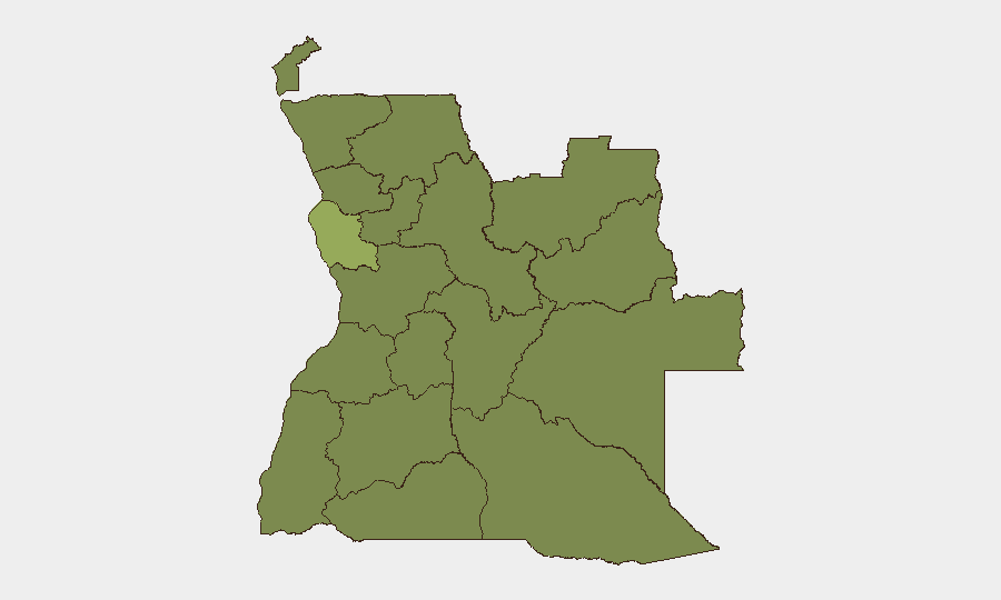
Angola holds a composite threat rank of #54 globally with a score of 37 across 53 tracked events, indicating moderate baseline risk concentrated in specific urban and resource-extraction zones. Luanda Province dominates the risk profile at 55.8—more than double the next-highest region—driven by urban crime, trafficking, and political sensitivity. The broader country exhibits stable governance but faces localized pressures from wildfire activity and sporadic detention incidents involving foreign nationals. The security trajectory remains contained but requires monitored attention in high-density urban and extractive-industry corridors.
Key Developments
- 2026-06-27 · Luanda Province: Arrest/detention incident involving a company and Chinese national(s) reported; details and location within Luanda not yet confirmed. Status of detainee(s) and reason for detention require clarification from in-country contacts or consular channels.
- 2026-06-28 · National: SADC Extraordinary Summit convened in Angola; primarily diplomatic/political in nature. No security incidents reported, but large-scale diplomatic events attract localized law-enforcement presence and temporary traffic/access restrictions in hosting venues.
- 2026-06-27 through 29 · Multiple Provinces: At least 11 active wildfires detected across Angola (event IDs 1029075, 1029082, 1029100, 1029103–106, 1029123–124, 1029126, 1029130, 1029134). Geographic distribution and threat to infrastructure or populated areas under analysis; wildfire risk may disrupt transport, air quality, and operations in affected zones.
Note on reporting limitations: Live web/X monitoring for Angola incidents in the preceding 24–48 hours has returned limited current incident data. The above reflects signals from GeoBit's event database. Corporate teams requiring real-time verification of breaking incidents are advised to cross-reference consular alerts, in-country security providers, and media outlets (e.g., Angop, VOA Angola service) in parallel.
Highest-Risk Areas
Luanda Province (55.8) is the dominant risk driver, reflecting concentration of urban crime, corruption, financial crime, and political attention in the capital and surrounding metropolitan areas. The 11 remaining provinces cluster at 25.8, indicating more uniform baseline risk tied to extractive industries (diamonds, oil), border porosity, and lower law-enforcement capacity outside Luanda. Northern provinces (Cabinda, Zaire, Lunda Norte/Sul, Bengo, Uíge) and central-eastern regions (Moxico, Bié, Malanje) merit attention for trafficking, informal mining, and limited state presence; however, the data signal suggests no acute escalation in these zones at present. Wildfire activity is geographically dispersed and may elevate localized risk to supply chains and personnel in rural/semi-rural areas.
How GeoBit Would Assist
Teams with personnel or assets in Angola should employ AOI Monitoring & Early Warning on Luanda and key extractive-industry zones to detect arrest patterns, civil unrest, or access disruptions in near-real time. OSINT fusion (X/Telegram, local media, radio SIGINT) on detention/arrest incidents and entity extraction on Chinese nationals and company names would clarify the 2026-06-27 event and inform consular notification or duty-of-care escalation. Environmental & Health data coupled with GIS & Spatial Analysis should track active wildfires and forecast smoke/air-quality impacts on operations and personnel safety.
7-Day Outlook
No imminent security escalation is indicated, but the detention incident and SADC summit create short-term friction points requiring monitoring through 2026-07-05. Wildfire activity will likely persist through the dry season; trajectory depends on rainfall patterns and fire-management response. Routine vigilance on Luanda crime (petty theft, armed robbery, carjacking) and extractive-zone trafficking should remain in force.
Highest-Risk Areas — Ranked
| # | State / Region | Risk |
|---|---|---|
| 1 | Luanda Province | 55.8 |
| 2 | Lunda Norte Province | 25.8 |
| 3 | Lunda Sul Province | 25.8 |
| 4 | Cabinda Province | 25.8 |
| 5 | Zaire Province | 25.8 |
| 6 | Bengo Province | 25.8 |
| 7 | Uíge Province | 25.8 |
| 8 | Cuanza Norte Province | 25.8 |
| 9 | Cuanza Sul Province | 25.8 |
| 10 | Malanje Province | 25.8 |
| 11 | Bié Province | 25.8 |
| 12 | Moxico Province | 25.8 |
Previous Daily Briefs
A new Angola brief is written every day — each with its own risk map and downloadable CSV. Here's the last week; use the calendar to go further back.
📅 Browse every day by calendar →
Highlighted days have a brief. Tap a day for that day's map & analysis, or “csv” for that day's dataset ($5).