Situation Summary
The Bahamas presents a stable security environment at the national level, with no discrete tracked incidents reported in the past 24–48 hours. Baseline crime remains concentrated in Nassau (New Providence) and Freeport, where armed robbery and gang-related violence occur intermittently; however, no new violence or civil unrest has been corroborated in current open-source monitoring. The threat trajectory remains consistent with long-standing endemic crime rather than escalation or systemic instability.
Key Developments
- No discrete security events reported (24–48h window). Live-web and open-source monitoring confirm no newly reported violent incidents, civil unrest, protests, political developments, or infrastructure failures in The Bahamas as of 25 July 2026.
- Baseline crime conditions persist. New Providence and Freeport continue to experience routine armed robbery and gang-related incidents typical of their risk profile, but no specific incidents have been flagged for the current reporting window.
- Infrastructure and transport remain operational. No new power outages, aviation disruptions, or transport failures have been reported in the past two days; earlier electricity and aviation issues do not reflect current-period developments.
- No civil unrest or political instability. Social-media and news monitoring indicates routine government and administrative activity with no evidence of protests, demonstrations, or political tension in the past 24–48 hours.
Highest-Risk Areas
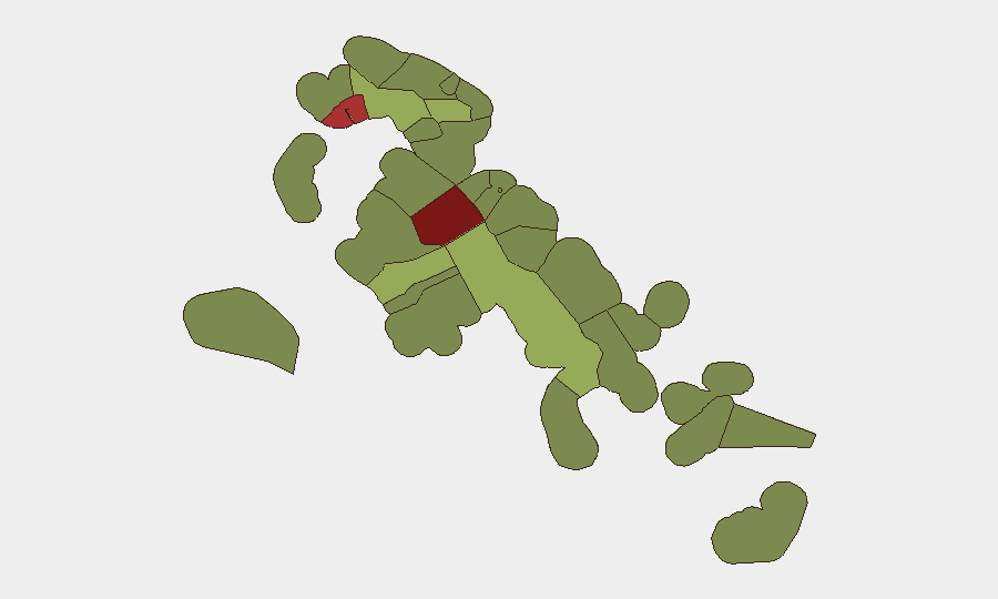
New Providence (risk 92) and the City of Freeport (risk 78) dominate the sub-national risk landscape and account for the majority of Bahamas' violent crime and armed robbery incidents. New Providence—home to Nassau, the capital and largest urban center—remains the primary focus for crime-mitigation effort and corporate risk management. Freeport, on Grand Bahama, presents a secondary high-risk urban cluster. The Family Islands and outer settlements (Central Abaco, Central Andros, Exuma, and East Grand Bahama) present moderate to low risk and are considerably safer for personnel and asset placement; risk declines sharply south and west of the central islands.
How GeoBit Would Assist
Intel Sweep and persistent AOI Monitoring & Early Warning on Nassau and Freeport would enable continuous detection of emerging crime spikes, gang activity, or civil unrest before local media reporting. OSINT fusion—combining X/Twitter, Telegram, and news-feed analysis—provides early signals of neighborhood-level incidents and travel advisories. Routing & Network Analysis supports duty-of-care teams in identifying safer transit corridors and contingency travel plans for personnel in high-risk zones, reducing exposure to armed-robbery hotspots.
7-Day Outlook
No significant escalation in Bahamas' security posture is anticipated over the next seven days. Personnel and assets in New Providence and Freeport should maintain standard crime-avoidance protocols (awareness, restricted movement after dark, security escorts). Family Island operations and travel remain low-risk; routine monitoring of open-source feeds will suffice to detect any anomalies.
GEOBIT THREAT RANKING: Bahamas #null globally | Composite threat score 15
SUBNATIONAL RISK FOCUS: New Providence (92) | Freeport (78)
LAST 24–48H TRACKED EVENTS: 1 (generic public statement, 23 July 2026)
Highest-Risk Areas — Ranked
| # | State / Region | Risk |
|---|---|---|
| 1 | New Providence | 92 |
| 2 | City of Freeport | 78 |
| 3 | Central Abaco | 52 |
| 4 | Central Andros | 48 |
| 5 | Exuma | 45 |
| 6 | East Grand Bahama | 42 |
| 7 | South Andros | 38 |
| 8 | North Abaco | 35 |
| 9 | North Eleuthera | 33 |
| 10 | South Abaco | 32 |
| 11 | Cat Island | 30 |
| 12 | Mangrove Cay | 28 |
Sources
Previous Daily Briefs
A new Bahamas brief is written every day — each with its own risk map and downloadable CSV. Here's the last week; use the calendar to go further back.
📅 Browse every day by calendar →
Highlighted days have a brief. Tap a day for that day's map & analysis, or “csv” for that day's dataset ($5).
Atlas — our AI intelligence desk — emails them this snapshot personally. Nothing else, no list.