Situation Summary
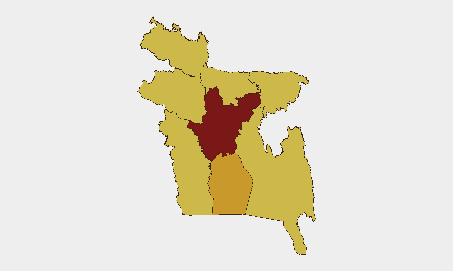
Bangladesh faces elevated geopolitical and border-security tensions as of 1 July 2026, driven by a surge in reported illegal cross-border push-in attempts by Indian Border Security Forces along the eastern frontier and a major strategic shift in port development toward China. Domestic political risk has also risen following former PM Sheikh Hasina's announcement of plans to return from India, which the current government views as destabilizing. Dhaka Division remains the highest-risk zone nationally (94.4 composite score), but border-adjacent areas and port infrastructure in the southwest now warrant heightened monitoring.
Key Developments
- Eastern Bangladesh–India Border (multiple sectors), 29–30 June 2026: Bangladesh's Home Minister reported that security forces thwarted a "massive surge in illegal push-in attempts" by Indian BSF within the past 24 hours; military alerts cite thousands of lives at risk and reinforced border posture in response.
- Bangladesh–India Border (unspecified eastern sectors), 30 June 2026: Official statements emphasize ongoing interception of cross-border forced-entry attempts and announce tightened national border-security monitoring and alert status.
- Mongla Port, Bagerhat District (southwest), late June 2026: Bangladesh completed a strategic shift in port-development partnership from India to China, now driving heightened Indian regional security concern and border-adjacent infrastructure monitoring.
- National Political Sphere (Dhaka-centric), current news cycle: Former PM Sheikh Hasina, speaking from India, announced her intent to return to Bangladesh later in 2026 and emphasized her commitment to restoring democracy; the current government has issued sharp public criticism, raising medium-term political-instability risk.
- Conventional Military and Small Arms Activity (national level), 29–30 June 2026: GEOBIT event feeds recorded multiple instances of conventional military-force deployments and small-arms combat incidents within Bangladesh in the past 48 hours, consistent with elevated border-security operations.
- Public Statements by Government and Opposition (Dhaka and regional centers), 28–30 June 2026: Ministry of National Security issued public threats; opposition MPs made statements concerning prison conditions and school access; government rejected opposition appeals, signaling political polarization and potential for civil unrest.
Highest-Risk Areas
Dhaka Division (94.4) dominates national risk due to its concentration of government, opposition activity, and security-force presence; border tensions and political-return rhetoric are likely to generate street-level unrest there. Barishal Division (72.1) ranks second, though open-source detail is limited; its proximity to port infrastructure and the Indian border makes it a secondary focus. Rajshahi, Mymensingh, Khulna, Chittagong, Rangpur, and Sylhet divisions (all 64.4–65.0) reflect endemic border stress, particularly along the eastern and southwestern frontiers where BSF confrontation and infrastructure-development shifts are reshaping local security dynamics.
How GeoBit Would Assist
Security and duty-of-care teams should deploy AOI Monitoring & Early Warning on Dhaka Division and eastern border sectors to detect escalation in military or protest activity in real time. OSINT fusion (X/Twitter, Telegram, Bengali-language sources, and YouTube commentary) will track opposition rhetoric, government responses, and border-community sentiment as the Hasina return narrative and port-development tensions evolve. Routing & Network Analysis can identify alternative travel corridors and safe egress points in Dhaka, Barisal, and border zones, while Satellite & Imagery analysis can monitor force concentrations and infrastructure activity around Mongla Port and key border checkpoints.
7-Day Outlook
Border tensions with India are likely to remain elevated for the near term, with sporadic reports of push-in attempts and tightened Bangladeshi security posture continuing. Political risk in and around Dhaka will grow if opposition movements mobilize in response to government rhetoric, or if Hasina's return timeline becomes more concrete. Infrastructure and maritime-asset risk will persist in southwestern zones (Barisal, Khulna, Bagerhat) as China's expanded role in Mongla Port intensifies regional geopolitical monitoring.
Highest-Risk Areas — Ranked
| # | State / Region | Risk |
|---|---|---|
| 1 | Dhaka Division | 94.4 |
| 2 | Barishal Division | 72.1 |
| 3 | Rajshahi Division | 65 |
| 4 | Mymensingh Division | 65 |
| 5 | Khulna Division | 64.4 |
| 6 | Chittagong Division | 64.4 |
| 7 | Rangpur Division | 64.4 |
| 8 | Sylhet Division | 64.4 |
Sources
Previous Daily Briefs
A new Bangladesh brief is written every day — each with its own risk map and downloadable CSV. Here's the last week; use the calendar to go further back.
📅 Browse every day by calendar →
Highlighted days have a brief. Tap a day for that day's map & analysis, or “csv” for that day's dataset ($5).