Situation Summary
Belize faces elevated and active street-level violence concentrated in urban centers, with three separate shooting incidents—including a confirmed double homicide—reported in Belize City within a 24-hour window as of August 3–4. Simultaneous recovery of illegal firearms and narcotics across multiple districts (Cayo, Belize District) signals continued gang and inter-cartel activity. A nationwide telecommunications outage on August 3 compounded operational challenges for emergency response and business continuity. The security picture remains volatile in urban hotspots, with police enforcement actions ongoing but no indication of de-escalation.
Key Developments
- Belize City, August 3–4 (within 24 hours): Three separate shooting incidents including one confirmed double homicide; police investigations active, locations and full victim details under release protocols. Indicator of gang or inter-cartel violence.
- Pomona Village, Stann Creek District, evening of August 3: Two men shot and injured; police investigating and linking the incident to local disputes. Extends violence beyond primary urban centers.
- Unitedville, Cayo District, August 3: Five individuals charged after police recovered an illegal firearm and ammunition during targeted operation, part of intensified gun-crime enforcement.
- Belize City, August 3: Police seized a firearm and suspected narcotics from a local man during operations targeting illegal weapons and drugs in urban hotspots.
- Lords Bank/Ladyville corridor, Belize District, August 3: New police substation opened to improve response times and community security in an area previously affected by crime and road incidents.
- Nationwide (BTL & SMART networks), afternoon/evening of August 3: Intermittent internet outages affecting fixed and mobile services from approximately 4:00 p.m. onward, potentially disrupting business communications and emergency dispatch coordination.
- National emergency services, late August 2–3: Over 40 personnel from Belize Defence Force, Coast Guard, National Fire Service, and Search and Rescue Institute completed CARICOM disaster management training, improving hurricane season and major incident response readiness ahead of the 2026 Atlantic season.
- Belize City & national, August 3–4: Forensic Science Service announced halting alcohol-container testing in minor public drinking cases, a procedural change criticized by police and Belize City Council as potentially weakening public order enforcement.
Highest-Risk Areas
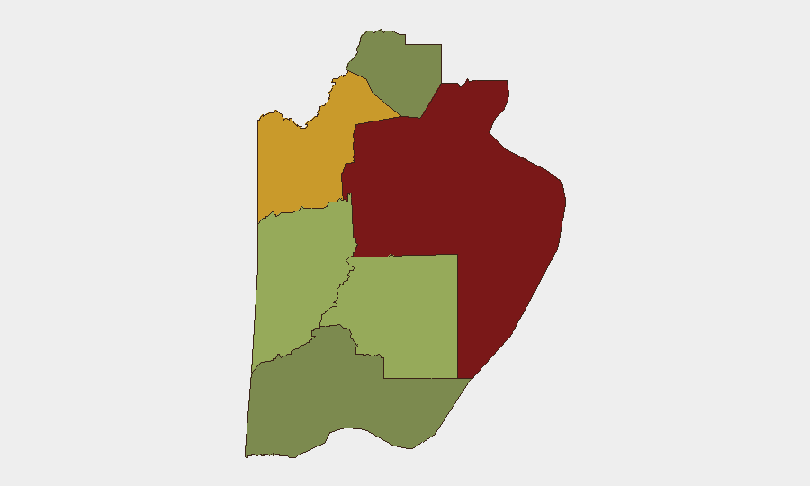
Belize District (risk 95) and Orange Walk District (risk 72) remain the primary drivers of national threat, with Belize City accounting for the majority of recent homicides and gang-linked shootings. Cayo District (risk 58) shows active firearms trafficking, while Stann Creek District (risk 48) is emerging as a secondary violence corridor, as evidenced by the Pomona shooting. Corozal and Toledo districts maintain substantially lower risk profiles. Urban density, gang presence, and drug-transit infrastructure in the north and central regions concentrate both perpetrator activity and civilian exposure.
How GeoBit Would Assist
Security teams would employ AOI Monitoring & Early Warning on Belize City, Orange Walk Town, and San Ignacio to detect upticks in shooting incidents and police operations in real time. Network & Actor Analysis would map gang structures, cartel presence, and supply routes across districts to predict secondary violence clusters. Intel Sweep and OSINT fusion (X/Twitter, local news, police radio signals via SIGINT) would triangulate incident locations, victim identities, and operational patterns faster than public release cycles, enabling duty-of-care teams to route personnel and assets away from active hotspots.
7-Day Outlook
Violence intensity in Belize City is likely to remain elevated through the week as police enforcement operations continue and rival groups respond to recent arrests and seizures. The telecommunications outage, if recurrent, may disrupt emergency coordination. Stann Creek and Cayo districts warrant closer monitoring for secondary violence spread; hurricane season readiness training of emergency services suggests preparedness infrastructure is improving, which may support stabilization efforts.
Highest-Risk Areas — Ranked
| # | State / Region | Risk |
|---|---|---|
| 1 | Belize District | 95 |
| 2 | Orange Walk District | 72 |
| 3 | Cayo District | 58 |
| 4 | Stann Creek District | 48 |
| 5 | Toledo District | 35 |
| 6 | Corozal District | 22 |
Sources
Previous Daily Briefs
A new Belize brief is written every day — each with its own risk map and downloadable CSV. Here's the last week; use the calendar to go further back.
📅 Browse every day by calendar →
Highlighted days have a brief. Tap a day for that day's map & analysis, or “csv” for that day's dataset ($5).
Atlas — our AI intelligence desk — emails them this snapshot personally. Nothing else, no list.