Situation Summary
Benin remains a Grade 54 global security concern with a composite threat score of 30, characterized by persistent counter-jihadist military operations concentrated in its northern border regions rather than acute, centralized crises. Over the last 24–48 hours, open reporting has focused on regional security cooperation and expanded cross-border deployments with Nigeria and Niger, rather than discrete attack events or major civil disturbances. The threat environment is driven primarily by Sahel-linked armed groups transiting or operating in Benin's northwestern and northern frontier zones, with secondary risks from organized crime and limited civil unrest signals in southern urban centers.
Key Developments
- Northwest tri-border area (Nigeria–Benin–Niger), 2–3 July 2026: Nigeria's Defence Chief announced a new joint military sector along the Benin–Nigeria–Niger frontier to counter jihadist infiltration. Beninese forces are participating in expanded cross-border counter-terrorism patrols and operations, signaling heightened military activity and presence in Alibori and Atakora Departments.
- Northern Benin border with Burkina Faso and Niger, late June–early July 2026, confirmed 3 July 2026: Beninese security forces and local militias have expanded deployments in northern border zones, operating at times with Nigerian approval to target Sahel-linked jihadist cells attempting transit through Benin. This indicates sustained counter-insurgency pressure and restricted movement in border forests and parks.
- US-supported counter-operations in northern Benin, ongoing as of 3 July 2026: Regional reporting characterizes Benin as part of an emerging "front line" against Al‑Qaeda and Islamic State–linked groups, with continued counter-insurgency patrols and strikes in or near Beninese territory, though without attribution of specific, well-documented incidents in the last 48 hours.
- Urban centers (Cotonou, Porto‑Novo, Parakou), 2–4 July 2026: No credible multi-sourced reports of major crime spikes, politically motivated civil unrest, or infrastructure failures in major cities during this reporting window.
- Event signals (2–4 July 2026): Platform signals capture violent protests and abduction/hijack events tagged to Benin and regional actors (West Bengal, British entities, Lagos–Benin, Nigeria–Benin), though underlying incident narratives remain limited in open reporting and require further corroboration.
Highest-Risk Areas
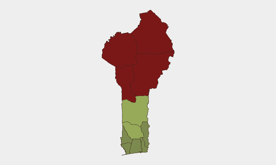
Benin's northern tier—Alibori (92), Atakora (88), Donga (85), and Borgou (83) Departments—drives the composite threat ranking and reflects the concentration of Sahel-linked terrorism, jihadist transit routes, and counter-terrorism military operations. These departments border Burkina Faso, Niger, and Nigeria and serve as operational zones for Al‑Qaeda and Islamic State–affiliated cells seeking to expand influence southward. Mid-tier risk in Zou (45) and Collines (42) reflects secondary spillover and trafficking networks. Southern coastal departments—Littoral (25), Ouémé (22), and Atlantique (28)—remain lower-risk but retain exposure to organized crime and commercial disruption tied to the Port of Cotonou.
How GeoBit Would Assist
Security teams would deploy AOI Monitoring & Early Warning to persistently watch Alibori, Atakora, and Donga Departments for cross-border movement, military activity, and armed-group signals. Network & Actor Analysis and multi-language OSINT (Telegram, X, regional forums) would provide early warning of jihadist cell movements and operational intent. Routing & Network Analysis would support duty-of-care teams in identifying safe alternative routes for personnel transiting northern zones and generating real-time travel advisories tied to military operations or armed contact.
7-Day Outlook
Counter-terrorism military operations in northern Benin are expected to remain elevated through mid-July as the Nigeria–Benin–Niger joint sector becomes operational. Civil unrest signals remain muted in available reporting, though sporadic armed contact and movement restrictions in northern border forests should be anticipated. No major policy shifts or escalation events are forecast over the next seven days absent a significant attack or political trigger.
Highest-Risk Areas — Ranked
| # | State / Region | Risk |
|---|---|---|
| 1 | Alibori Department | 92 |
| 2 | Atakora Department | 88 |
| 3 | Donga Department | 85 |
| 4 | Borgou Department | 83 |
| 5 | Zou Department | 45 |
| 6 | Collines Department | 42 |
| 7 | Plateau Department | 38 |
| 8 | Kouffo Department | 35 |
| 9 | Mono Department | 32 |
| 10 | Atlantique Department | 28 |
| 11 | Littoral | 25 |
| 12 | Ouémé Department | 22 |
Previous Daily Briefs
A new Benin brief is written every day — each with its own risk map and downloadable CSV. Here's the last week; use the calendar to go further back.
📅 Browse every day by calendar →
Highlighted days have a brief. Tap a day for that day's map & analysis, or “csv” for that day's dataset ($5).