Situation Summary
Botswana remains a low-threat environment globally (composite score 4/100), with no tracked conflict, terrorism, or civil unrest incidents. However, sub-national risk is concentrated in urban and mining centers—particularly Gaborone, South-East District, and Lobatse—driven by crime, economic pressures, and infrastructure vulnerabilities. Wildfire activity has been the dominant recent hazard signal. Overall security posture remains stable, but duty-of-care teams should maintain localized vigilance in higher-risk districts.
Key Developments
Recent event signals identified:
- Wildfire activity (multiple incidents, July 2026). Six separate wildfire events have been tracked across Botswana in recent weeks (event IDs 1029681, 1029754, 1029683, 1029528, 1029620, 1029596). Specific locations, dates, and containment status are not detailed in available intelligence summaries; GeoBit satellite and environmental monitoring is recommended for real-time extent assessment.
Note on 24–48 hour reporting gap:
Available open-source reporting from the last 48 hours contains government notices (Foot and Mouth Disease movement controls, corporal punishment policy suspension) and historical crime updates (cross-border cattle rustling in Okavango East, January–May period) rather than acute security incidents. No fresh conflict, unrest, or crime shocks have been confirmed in that window. This absence of reported incidents is consistent with Botswana's stable threat profile.
Highest-Risk Areas
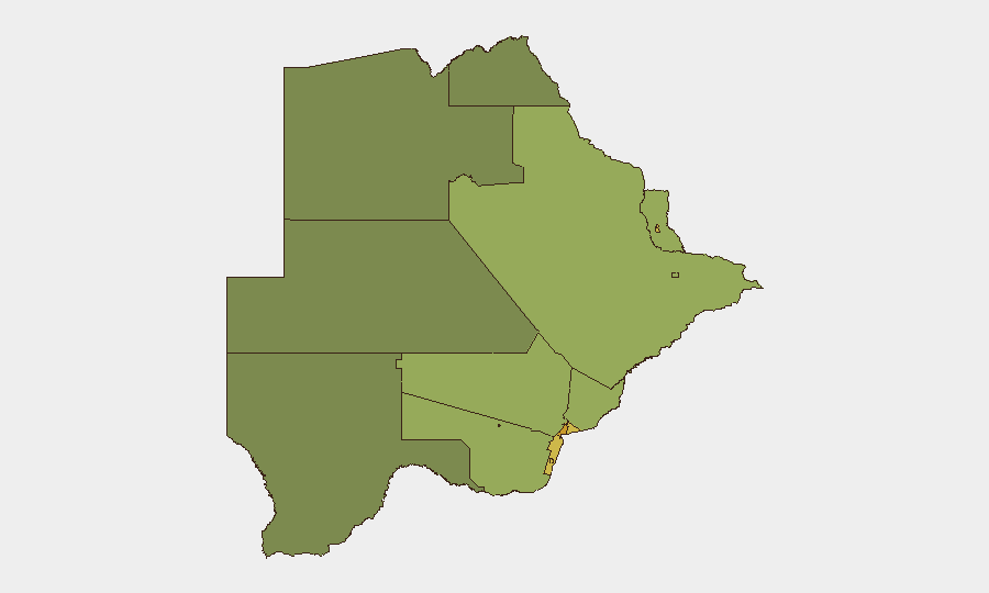
Urban centers and mining districts dominate the risk landscape. Gaborone (risk 72) leads due to concentration of economic activity, transient populations, and petty crime; South-East District (68) and Lobatse (65) follow, reflecting similar urban-crime and cross-border dynamics with South Africa. Francistown and Jwaneng (62, 61) face mining-sector-linked risks and informal-settlement vulnerabilities. Rural and northern districts (North-West, Central, North-East: 38–45) show substantially lower risk. Risk is primarily crime and economic-driven rather than political or conflict-based.
How GeoBit Would Assist
Intel Sweep and environmental monitoring would provide real-time wildfire location, extent, and trajectory—critical for duty-of-care teams protecting assets and personnel in fire-prone regions. AOI Monitoring & Early Warning with persistent satellite watch over Gaborone, South-East, and mining centers would detect emerging crime clusters, infrastructure incidents, or cross-border activity before escalation. Network & Actor Analysis focused on organized crime and smuggling networks (particularly cattle rustling and informal trade across the South Africa border) supports long-term risk management for supply chains and personnel routing. Routing & Network Analysis enables real-time alternative-route planning around fire zones and high-risk urban corridors.
7-Day Outlook
Wildfire risk will likely remain elevated through August given Southern African dry-season conditions; no major political, security, or economic shocks are forecast. Routine urban crime in Gaborone and secondary cities will persist; cross-border cattle rustling may continue opportunistically but shows no signs of organized escalation. Botswana's macroeconomic and political stability outlook remains unchanged. Teams should monitor wildfire public alerts and maintain standard duty-of-care protocols in Gaborone and mining towns.
Highest-Risk Areas — Ranked
| # | State / Region | Risk |
|---|---|---|
| 1 | Gaborone | 72 |
| 2 | South-East District | 68 |
| 3 | Lobatse | 65 |
| 4 | Francistown | 62 |
| 5 | Jwaneng | 61 |
| 6 | Selebi Phikwe | 58 |
| 7 | Southern District | 55 |
| 8 | Kgatleng District | 50 |
| 9 | Kweneng District | 48 |
| 10 | North-East District | 45 |
| 11 | Central District | 42 |
| 12 | North-West District | 38 |
Sources
Previous Daily Briefs
A new Botswana brief is written every day — each with its own risk map and downloadable CSV. Here's the last week; use the calendar to go further back.
📅 Browse every day by calendar →
Highlighted days have a brief. Tap a day for that day's map & analysis, or “csv” for that day's dataset ($5).
Atlas — our AI intelligence desk — emails them this snapshot personally. Nothing else, no list.