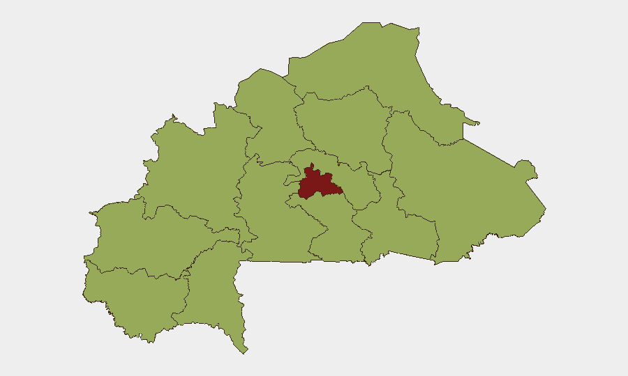
Situation Summary
Burkina Faso remains at elevated risk (composite threat score 79, #24 globally) with concentrated volatility in the Centre region and secondary pressure across nine peripheral zones. The security environment reflects ongoing institutional friction—including recent parliamentary tensions and military-governance dynamics—compounded by persistent Sahel-zone insurgency and organized criminal activity. The last 48 hours have generated multiple signals across public statements, military movement, and law enforcement action, though verified incident specificity remains limited in available open sources.
Key Developments
- 2 July, National Level – Prime Minister vs. Parliament public statement recorded; nature and outcome require clarification through direct institutional monitoring.
- 2 July, National Level – Arrest/detain event involving United States nationals reported; circumstances and location unclear from current signals.
- 2 July, National Level – Military force deployment linked to activist or civil-society event; scale and location not yet confirmed.
- 2 July, Aviation Sector – Public statement or incident flagged at Ouagadougou/national airway level; operational status and causation require urgent verification.
- 1 July, Law Enforcement – Unconventional violence reported between prosecutor and police; location and severity unknown.
- 30 June, Civil-Society Sphere – Multiple public statements documented involving school/educational institutions, employee/labor, and advocacy sectors; indicative of underlying social pressure but specific incidents remain unclear.
Note: Open-source verification for 30 June–2 July incidents is incomplete. The most clearly documented recent development is the 26 June diplomatic rupture with France, which falls outside this 48-hour window but represents a significant political shift affecting security posture, international cooperation, and potential for secondary instability.
Highest-Risk Areas
Centre region dominates the threat landscape (risk score 85.2)—significantly elevated above all other zones. The remaining 11 regions cluster at 55.2, indicating a two-tier risk structure: concentrated acute risk in and around Ouagadougou and the central corridor, with persistent secondary pressure (insurgency, criminal networks, community tension) distributed across Sahel, North, East, Upper-Basins, and border-adjacent zones. Centre-region risk likely reflects institutional volatility, security-force operations, and proximity to national decision-making; peripheral zones reflect militant activity and cross-border trafficking networks that have persisted since 2015.
How GeoBit Would Assist
A duty-of-care team with personnel or assets in Burkina Faso should deploy AOI Monitoring & Early Warning on Centre-region facilities and supply routes, combined with Network & Actor Analysis to track institutional and militant messaging across Telegram and X; Intel Sweep (event feeds, multi-language OSINT, sentiment analysis) would clarify the nature of the 1–2 July incidents in real time, while GIS & Spatial Analysis and satellite imagery would confirm military movements and airway disruption. Risk & Threat Assessment integrated with election monitoring and regime-stability search would track whether parliamentary or civil-society tensions escalate toward broader political instability.
7-Day Outlook
The next 7 days will likely clarify whether 1–2 July incidents represent routine institutional friction or signaling of deeper governance breakdown. The France rupture (26 June) removes a historical counterweight to military authority; any withdrawal of French military or intelligence presence may accelerate localized power consolidation or militant activity in Centre and North zones. Close watch on parliamentary and military communications, airway resumption, and any secondary arrests or military posturing is warranted.
Highest-Risk Areas — Ranked
| # | State / Region | Risk |
|---|---|---|
| 1 | Centre | 85.2 |
| 2 | Upper-Basins | 55.2 |
| 3 | Boucle du Mouhoun | 55.2 |
| 4 | Central-West | 55.2 |
| 5 | Central-South | 55.2 |
| 6 | Central-East | 55.2 |
| 7 | Waterfalls | 55.2 |
| 8 | Southwest | 55.2 |
| 9 | Sahel | 55.2 |
| 10 | Central-North | 55.2 |
| 11 | East | 55.2 |
| 12 | North | 55.2 |
Sources
Previous Daily Briefs
A new Burkina Faso brief is written every day — each with its own risk map and downloadable CSV. Here's the last week; use the calendar to go further back.
📅 Browse every day by calendar →
Highlighted days have a brief. Tap a day for that day's map & analysis, or “csv” for that day's dataset ($5).