Situation Summary
Chad remains a complex and fragmented security environment, ranked #29 globally with a composite threat score of 62. The country faces persistent instability driven by non-state armed groups, border porosity, and weak state capacity across much of the Sahel region. Recent diplomatic signals and investigative activity suggest ongoing governance tensions, though the security baseline has not dramatically shifted in the immediate 24–48 hours. Personnel and asset exposure remains concentrated in high-risk eastern and northern regions.
Key Developments
Open-source reporting does not currently surface verified, location-specific security or civil-unrest incidents in Chad dated within the last 24–48 hours. Recent signal activity (2026-06-21 to 2026-06-23) includes investigative actions, diplomatic disapproval exchanges, and public statements, but these do not yet map to confirmed ground events with operational impact on security posture or travel/movement corridors.
A hepatitis E alert remains under monitoring in Chad; health infrastructure fragility across rural and remote zones continues to complicate medical evacuation and duty-of-care response.
Highest-Risk Areas
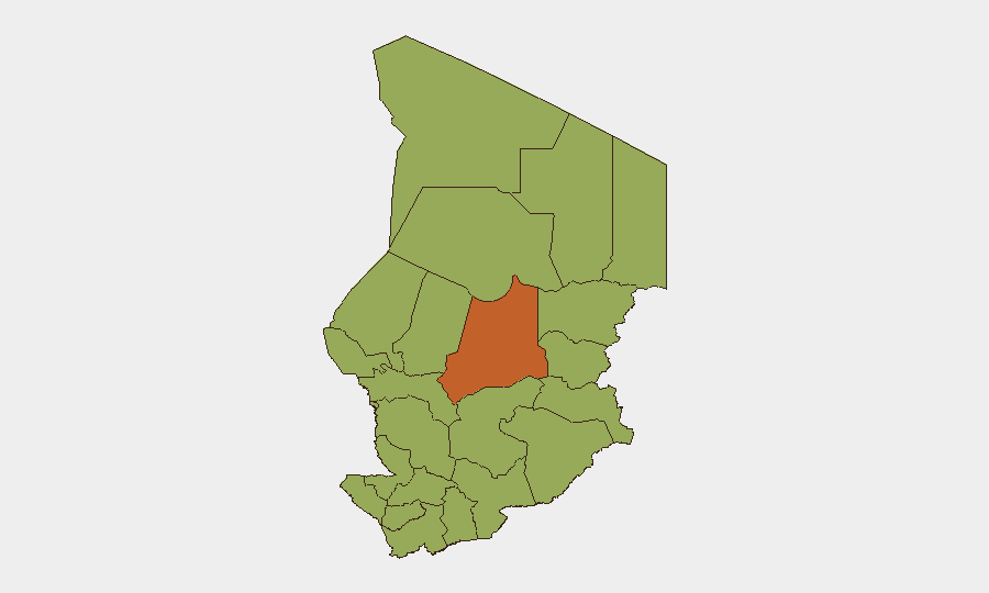
Batha region (risk score 73.6) is the primary driver of Chad's threat profile, significantly outpacing all other administrative divisions. The remaining eleven regions—including the eastern Ennedi zones, the northern Kanem and Lac provinces, and the capital region N'Djamena—cluster at a secondary risk tier (43.6 each), reflecting sustained exposure to armed-group activity, cross-border trafficking, and resource competition linked to the Lake Chad Basin crisis. Batha's elevation reflects historical insurgent presence, limited state authority, and transhumance-route vulnerability; the secondary tier reflects diffuse but persistent instability rather than acute localized threat.
How GeoBit Would Assist
Security teams should task Area-of-Interest Monitoring & Early Warning on Batha and eastern border zones to detect movement, activity spikes, and emerging incidents in real time. OSINT Fusion (X/Twitter, Telegram, local media, and radio SIGINT) provides continuous signal on political developments, armed-group communications, and checkpoint/roadblock activity. Conflict & Military mapping and Routing & Network Analysis support rapid assessment of safe and alternate corridors for personnel movement and supply logistics, particularly critical given the fragmented threat landscape.
7-Day Outlook
No imminent escalation is indicated by current reporting, but the diplomatic signals and investigative activity suggest heightened scrutiny of governance and political stability. Personnel should maintain heightened situational awareness in Batha and remain responsive to rapid reassessment if ground conditions change. Continued monitoring of health (hepatitis E) and cross-border armed-group activity is warranted, particularly ahead of any political or administrative announcements.
Next Brief: 2026-06-24 (24-hour cycle)
Data as of: 2026-06-23, 06:00 UTC
GeoBit Platform: Events, OSINT, threat scoring, sub-national risk ranking, open-source research
Highest-Risk Areas — Ranked
| # | State / Region | Risk |
|---|---|---|
| 1 | Batha | 73.6 |
| 2 | Ennedi-Ouest | 43.6 |
| 3 | Wadi Fira | 43.6 |
| 4 | Ouaddaï | 43.6 |
| 5 | Sila | 43.6 |
| 6 | Salamat | 43.6 |
| 7 | East Ennedi | 43.6 |
| 8 | Kanem | 43.6 |
| 9 | Lac | 43.6 |
| 10 | N'Djamena | 43.6 |
| 11 | Hadjer-Lamis | 43.6 |
| 12 | Chari-Baguirmi | 43.6 |
Sources
Previous Daily Briefs
A new Chad brief is written every day — each with its own risk map and downloadable CSV. Here's the last week; use the calendar to go further back.
📅 Browse every day by calendar →
Highlighted days have a brief. Tap a day for that day's map & analysis, or “csv” for that day's dataset ($5).