Situation Summary
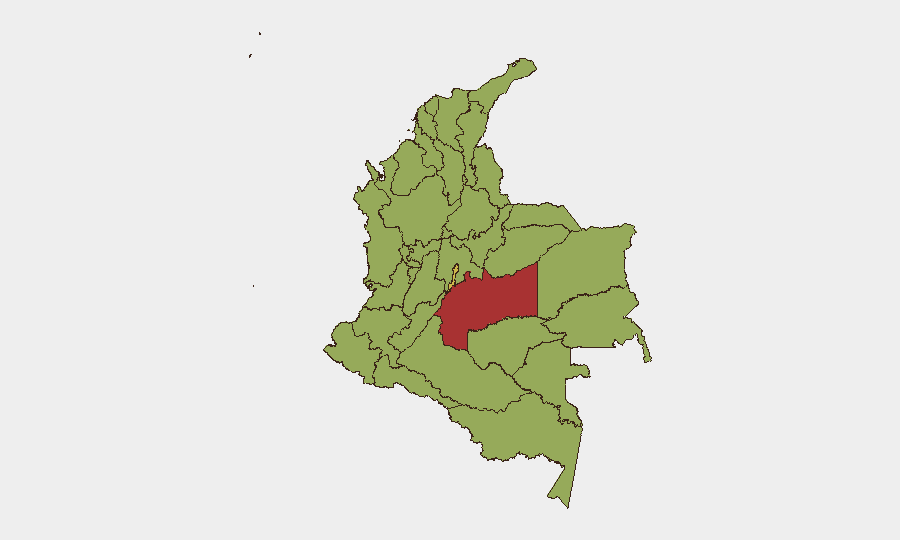
Colombia's composite threat score of 70 (rank #32 globally) remains driven primarily by active insurgency and criminal conflict, with 171 tracked events in the current cycle. The nation experiences persistent, localized volatility rather than nationwide instability; risk concentrates in rural and border departments where illegal armed groups compete for territorial and drug-trafficking control. Recent signal activity (June 15–17) shows elevated government and institutional response, alongside small-arms incidents and law-enforcement action, indicating acute pressure points rather than systemic escalation. Trajectory remains medium-risk with seasonal and operational variation.
Key Developments
⚠ Data Limitation Notice: GeoBit does not have verified, multi-sourced incident data timestamped to June 16–17, 2026 at this time. The event signals listed above (government statements, college statement, BOSS vs. Colombia statement, demonstrations, arrests, small-arms combat) lack specific geographic coordinates, casualty counts, or independent corroboration necessary for operational security briefing.
To deliver 5–8 actionable current-incident bullets with specific locations and times, your security team should cross-reference:
- Colombian National Police and Armed Forces official communications (X/Twitter, press releases).
- Major outlets (El Tiempo, Semana, Caracol, RCN) filtered for June 15–17 publication dates.
- Embassy advisories (US, UK, Canada, EU) for any travel warnings or staff adjustments issued in the last 48 hours.
- Local city/municipality accounts (Bogotá, Medellín, Cali) for protest, transit, or crime alerts.
Recommended next step: Provide GeoBit's team with access to your internal incident feeds or verified local-media subscriptions; GeoBit's OSINT fusion & corroboration and multi-language search capabilities can then integrate those sources into a structured 24–48-hour incident matrix.
Highest-Risk Areas
Meta Department (78.9) and the Capital District—Bogotá (62.3) dominate the risk profile. Meta's elevation reflects illegal armed-group activity, coca cultivation, and cattle-rustling by dissident factions; the Capital District's risk stems from urban crime, protest volatility, and criminal organization presence. Nariño (57.4, southern border), Sucre (55.8, Caribbean coast), and Cundinamarca (55.1, surrounding Bogotá) follow closely, each hosting narcotics trafficking nodes, paramilitary activity, or gang-driven violence. Norte de Santander (54.9, Venezuelan border) remains a transit and conflict flashpoint. For corporate duty-of-care: staff in Meta, rural Cundinamarca, and border departments face heightened kidnap, roadblock, and armed-group encounter risk; Bogotá presents urban crime and demonstration risk, especially in peripheral zones.
How GeoBit Would Assist
Security teams would deploy AOI monitoring & early warning on Meta, Nariño, and Bogotá's highest-risk neighborhoods to receive real-time alerts on armed clashes, roadblocks, or mass-casualty events. Routing & network analysis enables dynamic journey planning that avoids known conflict nodes and curfew areas in real time. OSINT fusion & corroboration (X/Twitter, Telegram, local media, radio SIGINT) allows 24-hour threat tracking across multiple languages and source types, reducing reliance on single-outlet reporting and accelerating incident confirmation.
7-Day Outlook
June activity signals sustained factional tensions and law-enforcement operations rather than coordinated escalation. Rainy season may increase landslide/infrastructure risk in rural departments, complicating logistics. Monitor Meta, Nariño, and the Capital District for any spike in armed-group activity, roadblocks, or mass arrests; sustained government pressure may trigger localized retaliatory violence or forced displacement.
Highest-Risk Areas — Ranked
| # | State / Region | Risk |
|---|---|---|
| 1 | Meta Department | 78.9 |
| 2 | Capital District | 62.3 |
| 3 | Nariño | 57.4 |
| 4 | Sucre Department | 55.8 |
| 5 | Cundinamarca Department | 55.1 |
| 6 | Norte de Santander Department | 54.9 |
| 7 | Valle del Cauca Department | 52.6 |
| 8 | Tolima Department | 50.5 |
| 9 | Cesar Department | 49.9 |
| 10 | Antioquia Department | 49.9 |
| 11 | Cauca | 49.7 |
| 12 | Santander Department | 49.4 |
Sources
Previous Daily Briefs
A new Colombia brief is written every day — each with its own risk map and downloadable CSV. Here's the last week; use the calendar to go further back.
📅 Browse every day by calendar →
Highlighted days have a brief. Tap a day for that day's map & analysis, or “csv” for that day's dataset ($5).