Situation Summary
Croatia remains a low-threat environment globally (ranked #148) with baseline security conditions stable as of 10 July 2026. No major incidents, civil unrest, terrorism, or infrastructure disruptions have been reported in the last 24–48 hours. The Australian government's Smartraveller advisory, updated 7 July and marked current on 10 July, maintains a "normal safety precautions" posture, noting that routine border delays and occasional diplomatic tensions with neighboring Serbia remain the primary operational considerations for corporate presence.
Key Developments
No verifiable, time-stamped security incidents or civil unrest events meeting operational thresholds were identified in Croatia during the last 24–48 hours via mainstream news, social media (X/Twitter), or official government travel advisories. Open-source monitoring confirmed no new terrorist threats, crime spikes, or infrastructure emergencies in that window. Existing diplomatic friction with Serbia (ongoing disapproval statements from both governments, recorded in GEOBIT event signals) reflects chronic bilateral tensions but has not escalated to active conflict or travel/commercial disruption as of 11 July. The Australian Smartraveller advisory remains the most recent official assessment (7–10 July 2026), with no updates suggesting deterioration.
Highest-Risk Areas
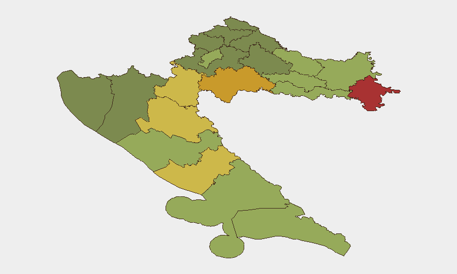
Sub-national risk concentration is pronounced in the eastern and southern border regions. Vukovar-Srijem County (risk 78), Sisak-Moslavina County (risk 72), and Karlovac County (risk 68) drive the majority of national composite threat; all three border Serbia and retain elevated risk profiles linked to historical conflict legacies, cross-border smuggling routes, and unresolved property/displacement issues stemming from the 1990s wars. Lika-Senj (65) and Šibenik-Knin (62) counties similarly occupy strategic positions in the Dinaric region with demonstrated vulnerability to organized crime and irregular migration flows. By contrast, the capital Zagreb (risk 50) and major coastal centers (Split-Dalmatia, 48) carry substantially lower risk and support the majority of foreign corporate activity. Security teams with operations in the eastern counties should prioritize localized intelligence collection and contingency planning; western and coastal zones warrant standard due-diligence protocols.
How GeoBit Would Assist
Corporate security teams in Croatia should deploy Intel Sweep and multi-language OSINT to monitor low-frequency but high-impact events (cross-border smuggling, organized-crime incidents, diplomatic escalation) in the high-risk eastern counties, coupled with Telegram & X/Twitter OSINT and sentiment analysis to detect rapid shifts in local sentiment or threats against foreign nationals or assets. AOI Monitoring & Early Warning applied to Vukovar-Srijem, Sisak-Moslavina, and Karlovac counties would provide persistent, automated alerting if incidents—security force activity, civil unrest, infrastructure disruption—emerge. Network & Actor Analysis can help map organized-crime and smuggling networks that occasionally affect supply chains and movement corridors in border zones.
7-Day Outlook
No significant escalation is forecast over the next week. Chronic diplomatic tension with Serbia is unlikely to translate to armed conflict or emergency evacuation scenarios in the near term. Corporate operations should maintain baseline protocols; personnel in eastern counties and border crossings should remain alert to localized disruptions (checkpoints, temporary closures) driven by customs enforcement or bilateral diplomatic posturing, but no systemic security deterioration is anticipated as of 11 July 2026.
Highest-Risk Areas — Ranked
| # | State / Region | Risk |
|---|---|---|
| 1 | Vukovar-Srijem County | 78 |
| 2 | Sisak-Moslavina County | 72 |
| 3 | Karlovac County | 68 |
| 4 | Lika-Senj County | 65 |
| 5 | Šibenik-Knin County | 62 |
| 6 | Brod-Posavina County | 58 |
| 7 | Zadar County | 55 |
| 8 | Osijek-Baranja County | 52 |
| 9 | City of Zagreb | 50 |
| 10 | Split-Dalmatia County | 48 |
| 11 | Požega-Slavonia County | 45 |
| 12 | Virovitica-Podravina County | 42 |
Sources
Previous Daily Briefs
A new Croatia brief is written every day — each with its own risk map and downloadable CSV. Here's the last week; use the calendar to go further back.
📅 Browse every day by calendar →
Highlighted days have a brief. Tap a day for that day's map & analysis, or “csv” for that day's dataset ($5).
Atlas — our AI intelligence desk — emails them this snapshot personally. Nothing else, no list.