Situation Summary
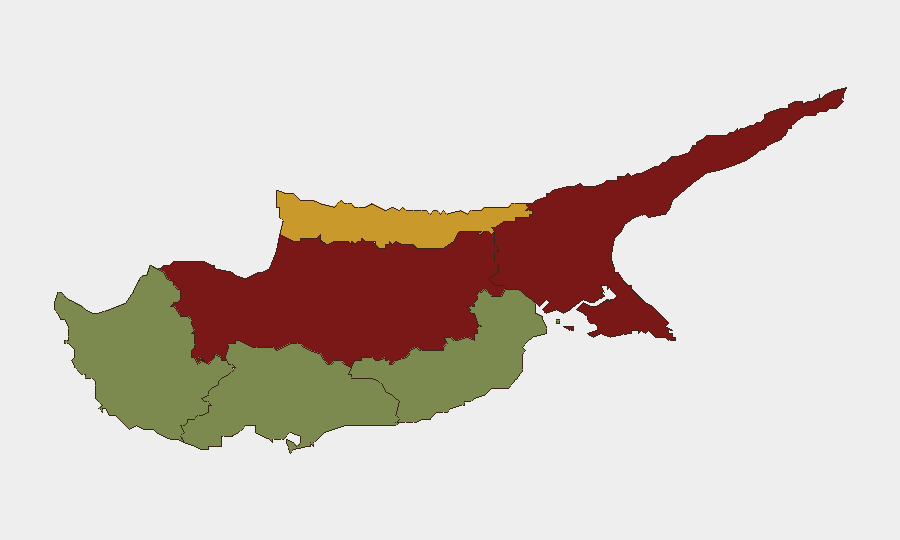
Cyprus remains a low-frequency, moderate-risk operating environment with no credible security incidents, civil unrest, or armed conflict reported in the last 24–48 hours. The composite national threat score of 4 reflects a stable baseline punctuated by routine administrative and diplomatic interactions. Risk concentration remains geographic, with the divided island's northern regions (Nicosia, Famagusta, Kyrenia) sustaining elevated composite scores due to partition-related sensitivities and historical friction; southern coastal zones are significantly quieter. The security picture is stable with no indicators of imminent deterioration.
Key Developments
No specific, independently confirmed security incidents, conflict events, or civil disturbances occurred on the island during 14–16 July 2026. Open-source monitoring (news feeds, specialist security briefs, X/Twitter OSINT) did not yield verifiable Cyprus-based events within the last 24–48 hours that meet operational incident criteria.
Regional/maritime exposure (background for awareness):
- M/V GFS Galaxy incident, Strait of Hormuz (10–13 July 2026, *outside current 24–48h window*): Cyprus-flagged container vessel struck by unidentified projectile attributed to Iranian forces; engine-room fire, one crew member missing, 23 rescued by Oman Navy. Relevant to Cyprus-linked maritime exposure but not a current on-island event.
- Limassol robbery series (13 July and prior, *outside current window*): Police investigated gang-coordinated robberies of food delivery workers; five incidents confirmed, twelfth arrest made. Reflects ongoing street-crime risk in southern coastal zone but not a new 24–48h development.
Highest-Risk Areas
Nicosia (composite 92) and Famagusta (88) drive the national risk profile, reflecting partition-related political sensitivities, administrative friction, and historical military presence in the north. Kyrenia (72), also in the Turkish Republic of Northern Cyprus, sustains elevated risk from similar structural tensions. By contrast, Larnaca (28), Limassol (22), and Paphos (18) are significantly lower-risk, with Limassol and Paphos experiencing routine crime but minimal political or conflict drivers. Risk is primarily political and administrative rather than kinetic; the geographic split reflects the island's unresolved partition status and differential governance structures rather than active violence.
How GeoBit Would Assist
Security teams operating in Cyprus would benefit from AOI (Area-of-Interest) Monitoring & Early Warning focused on Nicosia and Famagusta to detect political-administrative friction or rhetoric escalation ahead of operational impact. Intel Sweep, multi-language X/Telegram OSINT, and sentiment analysis provide real-time detection of Cyprus-Greece-EU diplomatic or community grievance shifts. For supply-chain and maritime exposure, Maritime & Aviation tracking combined with Economic & Trade monitoring would flag disruptions to Cyprus-flagged vessels (as with the July Hormuz incident) and regional shipping routes affecting corporate operations. GIS & Spatial Analysis supports targeted site hardening and travel routing in higher-risk northern zones.
7-Day Outlook
No indicators point to a near-term escalation of security incidents on the island itself. Risk remains structural and stable, driven by unresolved political partition rather than acute triggers. Monitoring should remain routine; any shift in Cyprus-EU, Cyprus-Greece, or Cyprus-Turkey diplomatic rhetoric would warrant rapid reassessment and briefing to duty-of-care teams with staff or assets in Nicosia or Famagusta.
Highest-Risk Areas — Ranked
| # | State / Region | Risk |
|---|---|---|
| 1 | Nicosia | 92 |
| 2 | Famagusta | 88 |
| 3 | Kyrenia | 72 |
| 4 | Larnaca | 28 |
| 5 | Limassol | 22 |
| 6 | Paphos | 18 |
Sources
Previous Daily Briefs
A new Cyprus brief is written every day — each with its own risk map and downloadable CSV. Here's the last week; use the calendar to go further back.
📅 Browse every day by calendar →
Highlighted days have a brief. Tap a day for that day's map & analysis, or “csv” for that day's dataset ($5).
Atlas — our AI intelligence desk — emails them this snapshot personally. Nothing else, no list.