Situation Summary
Dominican Republic remains a moderate global security concern (composite threat rank #81) with significant sub-national variation, driven primarily by gang violence, trafficking, and internal displacement in Greater Santo Domingo and surrounding provinces. No acute security incidents, civil unrest, or travel disruptions were confirmed via multi-source reporting in the last 24–48 hours. Three minor seismic events (M 3.3–3.9) were recorded near La Romana and Punta Cana in recent days, with no reported casualties or infrastructure damage. Overall security posture remains stable but geographically uneven.
Key Developments
- No verifiable acute incidents confirmed in last 24–48 hours. Web research, local news aggregation, and X/Twitter OSINT yielded no corroborated reports of shootings, protests, arrests, infrastructure failures, or travel disruptions within Dominican Republic proper during this window. Personal anecdotes and general safety commentary do not meet incident-level threshold.
- Seismic activity near tourism zones (recent, location-specific). Three low-magnitude earthquakes detected 13–89 km from La Romana and Punta Cana (M 3.3–3.9). No damage or disruption to airports, hotels, or transport corridors reported; consistent with normal regional seismicity.
- Wildfire alert flagged in Dominican Republic (recent, unspecified location). Geospatial alert system tracked wildfire (ID 1029053); extent, cause, and proximity to populated or strategic areas require local official confirmation to assess impact on air quality, utilities, or evacuation needs.
- Haiti–Dominican Republic deportation activity reported 2026-07-03. Bilateral enforcement action reflects ongoing migration-pressure management; no indication of border instability or cross-border armed activity. Standard administrative process.
Highest-Risk Areas
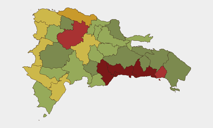
Santo Domingo (risk 92) and the Nacional District (88) drive the country's threat profile, followed by San Cristóbal, San Pedro de Macorís, and La Romana (83–85). These provinces concentrate organized crime activity, gang turf disputes, and human/drug trafficking networks. Risk drops significantly in northern and western provinces (Puerto Plata, Santiago, Dajabón) but remains elevated along the Haiti border (Elías Piña, Dajabón, Independencia) due to cross-border smuggling and irregular migration. Tourism-dependent areas (Punta Cana region, La Romana) face indirect exposure to gang violence in supply chains and port facilities, though direct tourist-zone incidents remain uncommon.
How GeoBit Would Assist
Intel Sweep and OSINT Fusion provide continuous monitoring of local Dominican news outlets, radio SIGINT, and social-media event feeds to detect emerging gang violence, trafficking disruptions, or infrastructure failures with minimal reporting lag. AOI Monitoring & Early Warning with persistent geospatial watch on high-risk provinces (Santo Domingo, San Pedro de Macorís) and critical facilities (ports, airports, highways) alerts security teams to incidents before they escalate. Conflict & Network Analysis maps gang structure and territorial disputes, enabling duty-of-care teams to assess exposure for employees or assets in specific neighborhoods and adjust movement patterns accordingly.
7-Day Outlook
No significant escalation in acute security threats is forecast over the next seven days absent external shocks (major gang leadership arrests, border incidents, natural disasters). Baseline gang violence and trafficking will likely persist at endemic levels in Greater Santo Domingo. Continued seismic monitoring and weather tracking are prudent given recent earthquake activity and wildfire alerts in the region.
Highest-Risk Areas — Ranked
| # | State / Region | Risk |
|---|---|---|
| 1 | Santo Domingo | 92 |
| 2 | Nacional District | 88 |
| 3 | San Cristóbal | 85 |
| 4 | San Pedro de Macorís | 83 |
| 5 | La Romana | 78 |
| 6 | Santiago | 76 |
| 7 | Puerto Plata | 72 |
| 8 | Elías Piña | 70 |
| 9 | Dajabón | 68 |
| 10 | Barahona | 65 |
| 11 | Independencia Province | 64 |
| 12 | La Vega | 62 |
Sources
Previous Daily Briefs
A new Dominican Republic brief is written every day — each with its own risk map and downloadable CSV. Here's the last week; use the calendar to go further back.
📅 Browse every day by calendar →
Highlighted days have a brief. Tap a day for that day's map & analysis, or “csv” for that day's dataset ($5).
Atlas — our AI intelligence desk — emails them this snapshot personally. Nothing else, no list.