Situation Summary
DR Congo remains at global threat rank #33 (score 71), with civil conflict as the primary driver and 2,639 tracked events on record. The security picture is currently dominated by cascading crises: an active Ebola outbreak in the northeast (Ituri, North Kivu, South Kivu) that is expanding daily into new health zones, combined with armed group activity in the eastern provinces and ongoing political tensions in Kinshasa. The outbreak is generating secondary security incidents as community mistrust of health responders triggers attacks on medical facilities and personnel, compounding humanitarian access challenges and creating dual-layer risk for organizations operating in affected zones.
Key Developments
- Bunia, Ituri Province (12–13 June 2026): IFRC publicly denounced an attack on Red Cross burial teams conducting safe burials during Ebola response operations, with multiple personnel injured. This reflects escalating hostility toward outbreak containment efforts in the outbreak epicenter.
- Rwampara area, Ituri Province (12–13 June 2026): Social media reports document residents breaching an Ebola treatment center, setting fires inside the facility, and incinerating a body. Sources indicate this escalated within the preceding 48 hours, driven by community resistance to burial protocols and institutional distrust.
- Ituri, North Kivu, South Kivu (12–13 June 2026): WHO officials report the Ebola outbreak is spreading into new health zones on a near-daily basis, with confirmed transmission in three provinces and evidence of local community spread in newly affected areas. Isolation capacity is reported below anticipated demand.
- Multiple Ituri localities (12–13 June 2026): Human Rights Watch documents recurrent community-led attacks on Ebola response infrastructure, including intrusions into hospitals and medical tents, and ongoing demands for body returns. These incidents reflect deepening breakdown in community–responder cooperation during active case management.
- Chad regional signal (12 June 2026): A disapproval statement from Chad was flagged in event signals, likely linked to cross-border displacement or political positioning related to eastern DRC instability; full context requires corroboration.
- Kinshasa resident statements (12 June 2026): Public statements by Kinshasa residents were flagged; these may reflect economic or political grievances but lack sufficient detail in available open sources.
Highest-Risk Areas
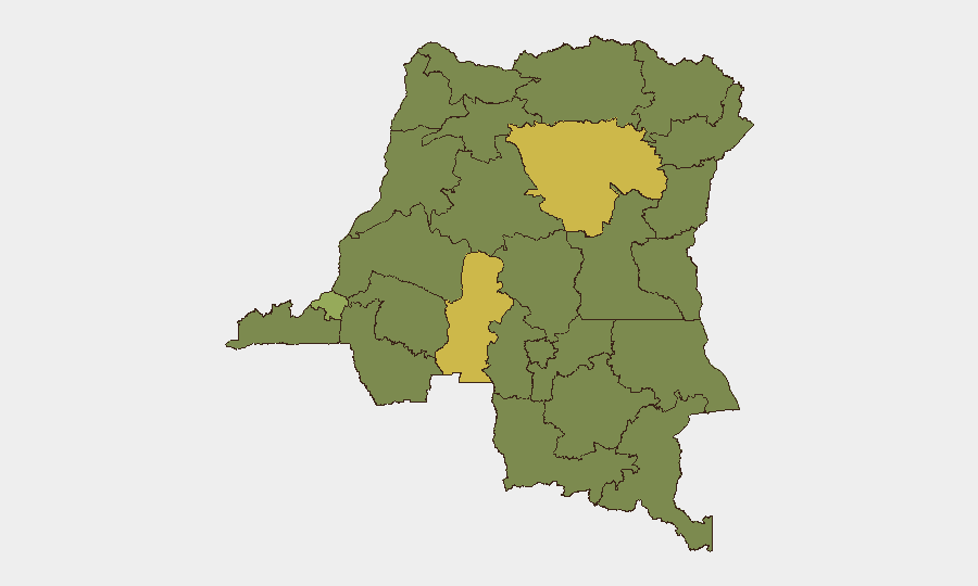
Tshopo and Kasai provinces drive the composite threat score, each exceeding 64, primarily due to ongoing armed-group activity and civil-conflict dynamics. Ituri Province, ranked 12th overall but currently the epicenter of Ebola-related security incidents, presents acute secondary risk from community violence targeting health workers and facilities; this outbreak-driven instability is expanding faster than historical baselines. Kinshasa (rank 3) remains elevated due to political tension and urban crime, while the northern belt (Nord-Ubangi, Mongala, Upper Uele) sustains baseline conflict-related threat from non-state armed groups. Organizations with personnel or assets in Ituri should treat this province as a priority re-assessment zone given the rapid convergence of epidemiological and security drivers.
How GeoBit Would Assist
Persistent AOI Monitoring & Early Warning would enable security teams to detect facility attacks, crowd movements, and incidents targeting health infrastructure in Ituri and neighboring zones in near-real time. Intel Sweep and multi-language OSINT fusion would capture emerging community sentiment, social-media mobilization against responders, and cross-border displacement signals before they escalate. Conflict & Military analysis and Network & Actor mapping would contextualize attacks within broader armed-group activity and supply alternative route planning for personnel and asset movements.
7-Day Outlook
The Ebola outbreak trajectory is sharply upward, with daily spread into new zones and no evidence of containment. Secondary security incidents targeting responders are likely to intensify as community mistrust deepens. Unless significant operational or communication changes are implemented by health authorities, staff safety risks will remain elevated across Ituri and adjacent provinces through mid-to-late June.
Highest-Risk Areas — Ranked
| # | State / Region | Risk |
|---|---|---|
| 1 | Tshopo | 68.2 |
| 2 | Kasai | 64.2 |
| 3 | Kinshasa | 40.1 |
| 4 | Maniema | 38.1 |
| 5 | Sud-Ubangi | 38.1 |
| 6 | Équateur | 38.1 |
| 7 | Nord-Ubangi | 38.1 |
| 8 | Mongala | 38.1 |
| 9 | Lower Uele | 38.1 |
| 10 | Tshuapa | 38.1 |
| 11 | Upper Uele | 38.1 |
| 12 | Ituri | 38.1 |
Sources
Previous Daily Briefs
A new DR Congo brief is written every day — each with its own risk map and downloadable CSV. Here's the last week; use the calendar to go further back.
📅 Browse every day by calendar →
Highlighted days have a brief. Tap a day for that day's map & analysis, or “csv” for that day's dataset ($5).