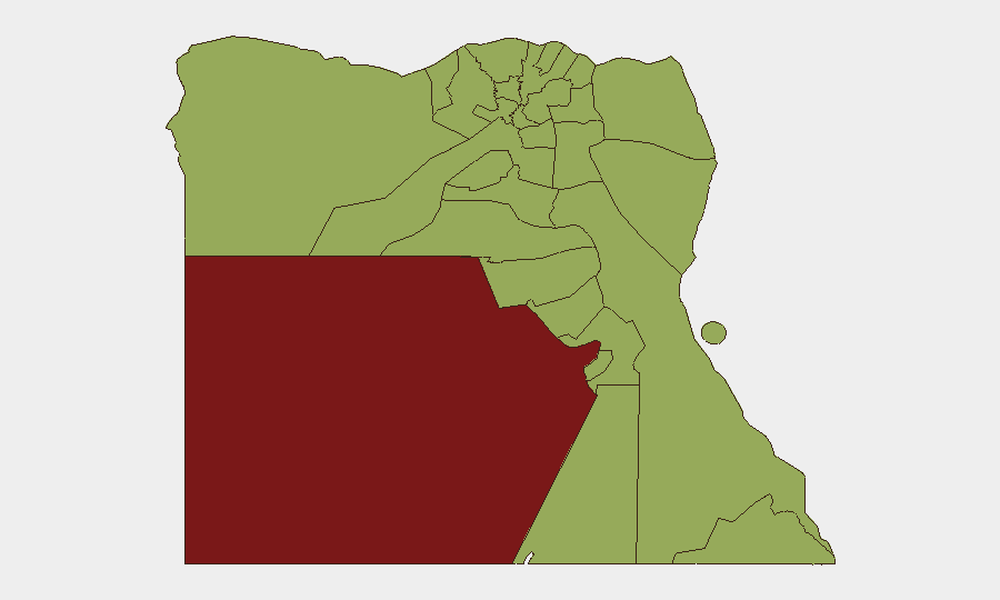
Situation Summary
Egypt remains a moderately elevated threat environment (global rank #24, composite score 75) with 103 tracked events, but recent signals reflect diplomatic friction and infrastructure developments rather than acute domestic violence or civil unrest. The most significant activity in the past 48 hours centers on state-level posturing abroad and major domestic security infrastructure upgrades, not widespread instability inside Egypt's borders. Baseline vigilance remains warranted for personnel and assets in high-risk sub-national zones, particularly New Valley and the greater Cairo metropolitan area.
Key Developments
- Dallas, Texas, USA – 5 July 2026: A physical altercation occurred between Egypt's national football team director Ibrahim Hassan and U.S. hotel security staff at the team's World Cup hotel. Officers pushed members of the Egyptian delegation during a crowd-management incident involving a child attempting to photograph players. Egyptian consulate officials intervened to resolve the confrontation; one U.S. officer was subsequently removed from the security detail. Social media circulation of videos prompted official statements from both the Egyptian Football Association and U.S. authorities.
- New Administrative Capital (near Cairo), Egypt – 4 July 2026: Egypt inaugurated "The Octagon," described as one of the world's largest integrated military and national-security command headquarters. The facility represents a significant expansion of centralized defense and command infrastructure with advanced technologies.
- Dakhla Oasis and Marina el-Alamein, Egypt – 4 July 2026 (announced): Egypt's Tourism and Antiquities Ministry announced the discovery of a well-preserved Byzantine-era residential city in Dakhla Oasis and 18 newly uncovered ancient tombs at Marina el-Alamein (~100 km west of Alexandria). Both announcements were explicitly framed by authorities as efforts to bolster tourism and economic stability, with potential implications for future travel and infrastructure planning in remote desert and Mediterranean coastal zones.
Highest-Risk Areas
New Valley (82.6) and Cairo (58.5) drive the country's composite threat profile, with Giza, Alexandria, and the Sinai Peninsula and Red Sea regions clustered in the 52–56 range. New Valley's elevated risk reflects sparse population density, limited state presence, and historical trafficking and smuggling activity. Cairo's prominence reflects population concentration, political sensitivity, and the density of state and diplomatic infrastructure. The clustering of Sinai Peninsula zones (North, South) with the Red Sea and Halaib Triangle suggests regional volatility tied to militant activity, maritime security concerns, and border-administration friction—though no acute escalation has been confirmed in the past 48 hours.
How GeoBit Would Assist
Security teams managing personnel or assets in Egypt should use Intel Sweep and multi-language OSINT (X/Twitter, Telegram, YouTube) to track early signals of civil unrest, protest activity, or security-force deployments in real time. AOI Monitoring with alerting on Cairo, Alexandria, and New Valley enables persistent watch of high-risk zones and immediate notification of significant incidents. Network & Actor Analysis paired with regime-stability assessment helps identify shifts in elite cohesion or state capacity that may precede broader instability. Routing & Network Analysis supports alternative journey planning and facility-access protocols in response to localized friction or checkpoints.
7-Day Outlook
No imminent escalation in domestic instability is signaled by the current event stream. The inauguration of expanded state command infrastructure and tourism-sector promotion suggest government focus on consolidation and economic activity rather than acute crisis response. Monitoring should remain continuous on North Sinai and Red Sea zones for any resurgence in militant activity, and on Cairo's political environment ahead of any scheduled government announcements or diplomatic events.
Highest-Risk Areas — Ranked
| # | State / Region | Risk |
|---|---|---|
| 1 | New Valley | 82.6 |
| 2 | Cairo | 58.5 |
| 3 | Giza | 56.3 |
| 4 | Alexandria | 54.1 |
| 5 | Ad Dakahliya | 54.1 |
| 6 | North Sinai | 52.6 |
| 7 | Qena | 52.6 |
| 8 | South Sinai | 52.6 |
| 9 | Red Sea | 52.6 |
| 10 | Halaib Triangle | 52.6 |
| 11 | Matruh | 52.6 |
| 12 | Kafr El Sheikh | 52.6 |
Sources
Previous Daily Briefs
A new Egypt brief is written every day — each with its own risk map and downloadable CSV. Here's the last week; use the calendar to go further back.
📅 Browse every day by calendar →
Highlighted days have a brief. Tap a day for that day's map & analysis, or “csv” for that day's dataset ($5).
Atlas — our AI intelligence desk — emails them this snapshot personally. Nothing else, no list.