Situation Summary
Eritrea remains a stable-ranking global security environment (rank #51, composite score 29) with no confirmed incident-level events inside the country in the last 24–48 hours. However, active high-level military–political engagement between Eritrea and Sudan, combined with sharply deteriorated conditions along Eritrea's southern frontier with Ethiopia, signal elevated operational risk linked to potential border escalation and cross-border military dynamics. The security trajectory is increasingly defined by regional conflict spillover rather than internal instability.
Key Developments
- Asmara, 17 July 2026 – Sudan's military leader General Abdel Fattah Al-Burhan conducted a surprise visit to Asmara for high-level consultations with President Isaias Afwerki on regional security and border tensions, signaling active Eritrean alignment with Sudan's military leadership amid volatile Sudan–Ethiopia conflict.
- Ethiopia–Eritrea frontier, through 17 July 2026 – Geobit and humanitarian monitoring sources document renewed militarization and confirmed Eritrean Defense Forces (EDF) presence inside Ethiopian territory, with sharply elevated risk of rapid escalation and potential border-crossing closures.
- Tigray border zone, through mid-July 2026 – Forced recruitment, abductions of civilians and minors, and ongoing EDF presence in Ethiopia's Tigray region are intensifying the militarized environment directly adjacent to Eritrea's southern border, increasing spillover risk.
- Digital and tech infrastructure policy, noted 17 July 2026 – Regional commentary documents Eritrea's stated focus on digital and technology infrastructure development, reflecting potential ongoing changes to state control of information systems and communications reliability.
- Humanitarian and cross-border operational status, advisory published 17 July 2026 – Fresh duty-of-care assessments emphasize uncertainty over border-crossing operational status and warn that rapid escalation into armed conflict involving Eritrea cannot be discounted.
Highest-Risk Areas
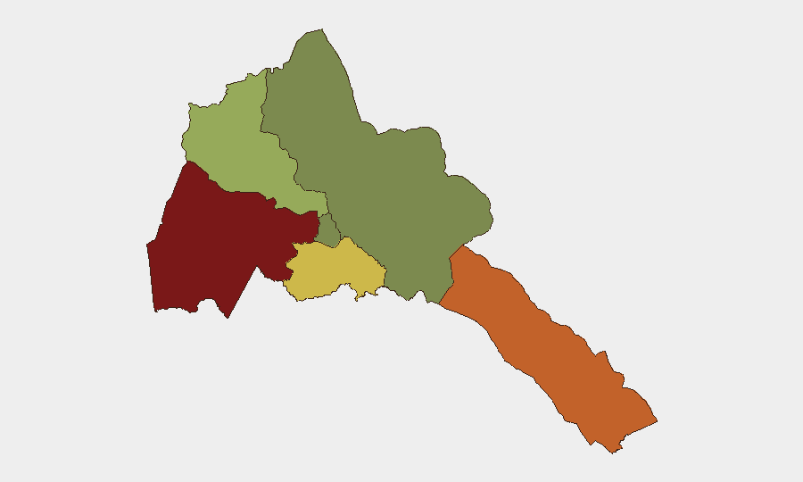
Gash-Barka (risk 92) and Southern Red Sea Region (risk 75) dominate the sub-national risk landscape, driven by proximity to Sudan and militarized border dynamics; Debub Region (68) faces elevated risk from Ethiopia–Eritrea frontier tensions and EDF positioning. Maekel Region (18), which includes the capital Asmara, remains substantially lower-risk and is the primary hub for expatriate presence and diplomatic activity. The Northern Red Sea Region (0) presents minimal tracked risk. Risk concentration in border regions reflects military posture and cross-border conflict contagion rather than internal civil unrest.
How GeoBit Would Assist
Teams with people or assets in Eritrea should employ AOI Monitoring & Early Warning on border regions (Gash-Barka, Southern Red Sea) to detect sudden military movements or crossing closures; Conflict & Military tracking (force structure, EDF positioning, weapons capability) to assess escalation indicators; and Intel Sweep (event feeds, OSINT fusion, X/Twitter/Telegram signals, multi-language search) to maintain real-time awareness of Sudan–Eritrea consultations and Ethiopia–Eritrea frontier developments. Routing & Network Analysis would support contingency planning for alternative travel and logistics routes should border crossings become restricted.
7-Day Outlook
The next week will likely see continued high-level military–political engagement between Eritrea and Sudan, with no immediate de-escalation expected along the Ethiopia–Eritrea frontier. Border-crossing status and overland movement restrictions remain the primary operational variables; rapid changes in crossing accessibility or armed clashes along the southern border cannot be ruled out. Organizations should maintain heightened situational awareness and contingency plans for movement disruption in the next 5–7 days.
Highest-Risk Areas — Ranked
| # | State / Region | Risk |
|---|---|---|
| 1 | Gash-Barka | 92 |
| 2 | Southern Red Sea Region | 75 |
| 3 | Debub Region | 68 |
| 4 | Anseba | 55 |
| 5 | Maekel Region | 18 |
| 6 | Northen Red Sea Region | 0 |
Sources
Previous Daily Briefs
A new Eritrea brief is written every day — each with its own risk map and downloadable CSV. Here's the last week; use the calendar to go further back.
📅 Browse every day by calendar →
Highlighted days have a brief. Tap a day for that day's map & analysis, or “csv” for that day's dataset ($5).
Atlas — our AI intelligence desk — emails them this snapshot personally. Nothing else, no list.