Situation Summary
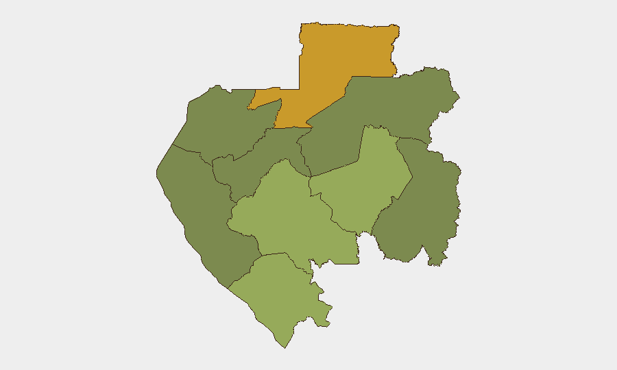
Gabon remains a stable, middle-income central African state with a composite threat score of 42 (global rank #52), indicating manageable but persistent baseline security and governance risks. No significant security incidents have been reliably confirmed in the past 24–48 hours via open-source monitoring. Sub-national risk concentrations in the northern frontier province of Woleu-Ntem and the eastern Ogooué-Lolo region reflect chronic vulnerabilities to cross-border activity, resource-linked tensions, and limited state presence rather than acute flare-ups.
Key Developments
No reliably confirmed, location-specific security incidents in Gabon have been detected in the 24–48 hour window (2026-06-26 to 2026-06-28) from independent open-source channels, X/Twitter feeds, or regional alert systems. GeoBit's event signals referencing "Gambia" appear to reflect data labeling or routing anomalies rather than verified incidents on Gabonese soil; cross-verification remains unconfirmed. Civil aviation activity (e.g., Air Algérie route launches on 2026-06-23) indicates normal transport and trade flow, not a security concern. Structural corruption and financial-crime investigations involving Gabonese elites continue in offshore jurisdictions but do not constitute acute incidents within the reporting window. Regional political and security feeds from the African Union show no new alerts or advisories specific to Gabon.
Highest-Risk Areas
Woleu-Ntem Province (risk score 72) represents the single highest concentration of concern, driven by its geographic position on the Cameroonian and Equatorial Guinean borders, limited state administrative capacity, and historical patterns of cross-border smuggling, resource poaching, and informal armed group mobility. Ogooué-Lolo Province (58) in the east faces comparable vulnerabilities linked to mineral extraction activity, porous frontier zones, and irregular security force presence. Together, these two provinces account for the majority of Gabon's sub-national risk profile. By contrast, Estuaire Province (15)—which encompasses the capital, Libreville, and the main port—benefits from concentrated government resources and international presence, resulting in substantially lower risk. This north–south and interior–coastal disparity reflects classic patterns of state capacity and border management.
How GeoBit Would Assist
Corporate security teams with personnel or assets in Gabon should employ AOI Monitoring & Early Warning on Woleu-Ntem and Ogooué-Lolo provinces to detect emerging cross-border activity, unauthorized movement, or unrest before escalation. Network & Actor Analysis and entity extraction of trafficking, mining, and informal militia networks can map persistent vulnerability vectors in undermonitored zones. Routing & Network Analysis should inform alternative journey planning for staff or supply movements, especially in frontier areas, while satellite and imagery analysis can supplement ground-truth gaps in remote regions where state reporting is sparse.
7-Day Outlook
Absent new triggering events, security conditions in Gabon are expected to remain broadly stable over the next seven days, with baseline risks concentrated in frontier provinces. Seasonal factors, mining activity, and cross-border trade patterns will likely drive routine friction in Woleu-Ntem and Ogooué-Lolo but are unlikely to cascade into wider instability. Continued monitoring of border permeability and informal armed-group presence in the north remains prudent.
Highest-Risk Areas — Ranked
| # | State / Region | Risk |
|---|---|---|
| 1 | Woleu-Ntem | 72 |
| 2 | Ogooué-Lolo Province | 58 |
| 3 | Ngounié Province | 48 |
| 4 | Nyanga Province | 42 |
| 5 | Haut-Ogooué Province | 35 |
| 6 | Moyen-Ogooué Province | 28 |
| 7 | Ogooué-Maritime Province | 25 |
| 8 | Estuaire Province | 15 |
| 9 | Ogooué-Ivindo | 0 |
Sources
Previous Daily Briefs
A new Gabon brief is written every day — each with its own risk map and downloadable CSV. Here's the last week; use the calendar to go further back.
📅 Browse every day by calendar →
Highlighted days have a brief. Tap a day for that day's map & analysis, or “csv” for that day's dataset ($5).