Situation Summary
Guinea-Bissau remains operationally stable with no verified security incidents, civil unrest, armed conflict, or infrastructure disruptions recorded in the last 24–48 hours. Structurally elevated risk persists in the northern border regions—particularly Gabu, Oio, and Bafatá—due to proximity to instability in neighboring states, though no cross-border spillover events have been documented during the current window. The security environment is characterized by baseline fragility rather than active acute crisis, with capital and transport corridors remaining passable and functional.
Key Developments
- No verified incidents nationwide (1–2 August 2026). Multi-source OSINT monitoring—including Africa-focused security feeds, local media, and social-media analysis—confirms an absence of armed clashes, protests, roadblocks, airport/port disruptions, or major crime events across Guinea-Bissau territory.
- Northern border regions (Gabu, Oio, Bafatá). While these areas are designated as higher-risk due to structural factors and proximity to cross-border instability, no new spillover incidents (armed incursions, refugee movements, or banditry) have been recorded on Guinea-Bissau soil in the last 48 hours.
- Bissau (capital) security posture. No documented coups, armed clashes, large protests, or significant crime incidents have been corroborated in the capital during the reporting window; routine governance and commercial activity are ongoing.
- Transport and infrastructure. Roads, airports, and ports remain open and functional; no weather-related movement restrictions or power outages affecting travel have been reported in the last 24–48 hours.
- Unconfirmed social-media claims. Scattered online posts reference alleged "security tightening" or military movements, but lack clear timestamps, source attribution, and independent corroboration; these do not meet intelligence-grade verification standards for incident reporting.
- Regional context (no domestic impact). Neighboring states experience ongoing security operations and instability; however, current reporting explicitly notes no concrete, dated spillover affecting Guinea-Bissau during the current window.
Highest-Risk Areas
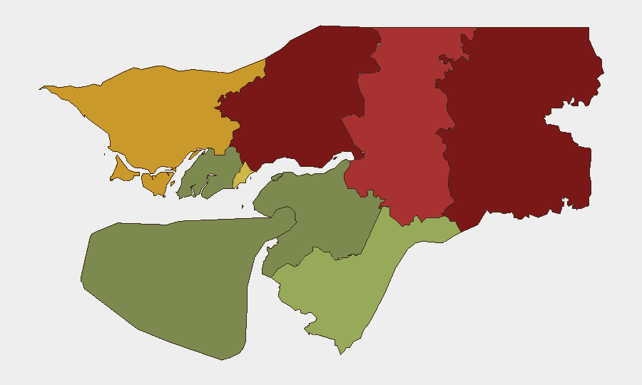
Gabu Region (composite risk 92) and Oio Region (85) dominate the sub-national risk profile, driven by geographic proximity to instability across borders, weak state capacity, and historical arms trafficking and cross-border banditry patterns. Bafatá (78) and Cacheu (72) represent secondary concentrations of risk along similar border-proximity and capacity factors. The Bissau Autonomous Sector (68), while lower-ranked, remains relevant due to population density and capital-city governance burden. Southern regions (Tombali, Quinara, Biombo, Bolama) carry substantially lower risk scores, reflecting greater distance from cross-border spillover routes and lower historical incident clustering.
How GeoBit Would Assist
Security teams should deploy AOI Monitoring & Early Warning on Gabu, Oio, and Bafatá to detect cross-border incursions, refugee movements, or armed activity with minimal latency. Intel Sweep (event feeds, X/Twitter OSINT, multi-language search) and Network & Actor Analysis enable continuous tracking of non-state armed groups, trafficking networks, and regime-stability indicators. GIS & Spatial Analysis combined with Routing & Network Analysis support journey planning and alternative corridors for personnel and assets in higher-risk regions.
7-Day Outlook
No acute drivers of escalation are evident in the current intelligence window. Baseline structural risk will remain elevated in border regions, but absence of current incidents and absence of reported regional spillover suggest continuity of the current low-active-threat posture over the next 7 days. Monitoring should remain persistent given the porous northern border and regional volatility.
[1] Multi-source corroboration standard: incident considered verified only when reported across ≥2 independent credible sources with geographic/temporal specificity.
Highest-Risk Areas — Ranked
| # | State / Region | Risk |
|---|---|---|
| 1 | Gabu Region | 92 |
| 2 | Oio Region | 85 |
| 3 | Bafatá Region | 78 |
| 4 | Cacheu Region | 72 |
| 5 | Bissau Autonomous Sector | 68 |
| 6 | Tombali Region | 45 |
| 7 | Quinara Region | 38 |
| 8 | Biombo Region | 32 |
| 9 | Bolama Region | 15 |
Sources
Previous Daily Briefs
A new Guinea-Bissau brief is written every day — each with its own risk map and downloadable CSV. Here's the last week; use the calendar to go further back.
📅 Browse every day by calendar →
Highlighted days have a brief. Tap a day for that day's map & analysis, or “csv” for that day's dataset ($5).
Atlas — our AI intelligence desk — emails them this snapshot personally. Nothing else, no list.