Situation Summary
Guyana remains a composite threat level 4 (relatively low by global standards) with no discrete security incidents confirmed in the past 24–48 hours. Underlying structural risks—violent crime, armed robbery, illegal firearms circulation, and mining-area disputes—persist at elevated levels in several regions, particularly coastal and interior zones. Political friction over governance and corruption allegations continues but has not escalated to civil unrest or security disruption. The security environment is stable but fragile, with localized violence and organized crime as the primary operating concerns for corporate assets and personnel.
Key Developments
No discrete security incidents have been independently verified in Guyana for 2026-08-01 or the 24–48 hours preceding this brief.
The most recent documented incident—a fatal shooting at an interior gold-mining dredge operation on or around 2026-07-31 (Region unconfirmed, interior mining district)—falls just outside the 48-hour window but underscores ongoing armed violence in mining camps and disputes between security personnel and workers. This reflects a pattern of lethal conflict in gold-extraction areas that remains operationally relevant.
Two house fires in Berbice (late July 2026, >48 hours old) included suspected arson, signaling continued fire-safety and deliberate-destruction risks in residential areas.
Ongoing police investigations spanning June–July 2026 continue into multiple murders and illegal-weapons discoveries across Corentyne (Berbice), Cuyuni, West Coast Demerara, and Georgetown, but these are routine investigative updates, not new incidents.
Political developments (late July 2026, >48 hours old) include Transparency International Guyana's call for an independent investigation into alleged conflicts of interest involving President Ali and opposition protests regarding the MV Barima maritime disaster, but neither has triggered civil unrest or security incidents.
Standing travel-risk and violent-crime advisories from OSAC and allied sources remain in effect nationwide, particularly for Georgetown (medium political-violence threat) and interior regions (armed robbery, road safety).
Highest-Risk Areas
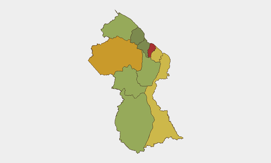
Demerara-Mahaica (risk 78) and Cuyuni-Mazaruni (risk 72) are the highest-risk regions, driven by concentrated violent crime, armed robbery, and gang activity in Georgetown and its outskirts, combined with lethal disputes in interior mining and dredging operations. Mahaica-Berbice (risk 65) and East Berbice-Corentyne (risk 62) follow, reflecting ongoing murder investigations, firearm trafficking, and organized criminal activity in coastal and border zones. Interior regions (Upper Demerara-Berbice, Potaro-Siparuni) face acute risks from mining-related violence and limited law-enforcement reach. Coastal urban centers remain the primary locus of street crime, armed robbery, and gang violence; interior mining and timber areas face sporadic but lethal disputes over resources and security.
How GeoBit Would Assist
Security teams would employ AOI Monitoring & Early Warning to establish persistent watch over corporate mining, logistics, and residential footprints in Demerara-Mahaica and Cuyuni-Mazaruni, with automated alerting on emerging violence or civil unrest. Intel Sweep and X/Twitter & Telegram OSINT with temporal and sentiment analysis would capture emerging threats and social indicators faster than public news cycles. GIS & Spatial Analysis combined with Routing & Network Analysis would enable real-time alternative-route planning for personnel and supply convoys in high-risk regions, minimizing exposure to armed-robbery hotspots.
7-Day Outlook
No imminent escalation is anticipated. Violent crime, mining-area disputes, and political friction are expected to remain at current elevated levels without triggering country-wide instability or travel restrictions. Corporate security teams should maintain heightened vigilance in Demerara-Mahaica and Cuyuni-Mazaruni and monitor mining operations for labor and resource-dispute indicators.
Highest-Risk Areas — Ranked
| # | State / Region | Risk |
|---|---|---|
| 1 | Demerara-Mahaica | 78 |
| 2 | Cuyuni-Mazaruni | 72 |
| 3 | Mahaica-Berbice | 65 |
| 4 | East Berbice-Corentyne | 62 |
| 5 | Upper Demerara-Berbice | 58 |
| 6 | Potaro-Siparuni | 48 |
| 7 | Barima-Waini | 45 |
| 8 | Upper Takutu-Upper Essequibo | 42 |
| 9 | Pomeroon-Supenaam | 38 |
| 10 | Essequibo Islands | 35 |
Sources
Previous Daily Briefs
A new Guyana brief is written every day — each with its own risk map and downloadable CSV. Here's the last week; use the calendar to go further back.
📅 Browse every day by calendar →
Highlighted days have a brief. Tap a day for that day's map & analysis, or “csv” for that day's dataset ($5).
Atlas — our AI intelligence desk — emails them this snapshot personally. Nothing else, no list.