Situation Summary
Israel remains at composite threat level 3 globally, driven by active military operations along the Lebanon border and sustained domestic security tensions. As of 2026-06-19–20, Israeli forces are conducting sustained air and ground operations in southern Lebanon in response to Hezbollah attacks, with reported casualty figures and strike counts indicating major escalation despite ceasefire positioning. Northern Israel faces ongoing short-notice threats including rocket fire, UAV attacks, and infiltration attempts; simultaneously, domestic political rhetoric has intensified, and regional diplomatic efforts (U.S.–Iran talks) have been postponed due to the military escalation.
Key Developments
- Lebanon–Israel border, 2026-06-19 overnight: Israeli Defense Force conducted over 150 strikes into southern Lebanon since midnight, with Lebanese health ministry reporting at least 47 killed. French sources independently confirmed IDF strikes on 80 targets and numerous Hezbollah casualties. This represents the most intensive single operational period in the current escalation cycle.
- Northern Israel communities, 2026-06-19: Hezbollah claimed a wave of attacks across the prior 48 hours including rocket fire, explosive UAVs, IEDs, a missile strike, and an infiltration attempt, with claimed Israeli casualty figures of 5 killed and 12 wounded. These attacks underscore sustained capability to strike populated areas with minimal warning.
- Israeli military operations, 2026-06-19: Four Israeli soldiers killed and five wounded in operations; Israeli national security messaging indicates continued operational tempo in southern Lebanon despite ceasefire statements, suggesting ground and air operations will persist.
- Political escalation rhetoric, 2026-06-19: Israel's National Security Minister stated "all of Lebanon must burn" following soldier casualties. While rhetorical, such statements signal political pressure for sustained military response and reduce likelihood of near-term de-escalation.
- Regional diplomatic impact, 2026-06-19: U.S.–Iran nuclear talks scheduled for Switzerland were postponed following Israeli strikes on Lebanon. This indirect effect indicates spillover risk to broader regional stability and potential for wider state-actor involvement.
- Ceasefire credibility, 2026-06-19: Despite public ceasefire commitments from Israeli officials, military briefings indicate Israeli forces will continue operations as needed in southern Lebanon to protect northern communities. Gap between public positioning and operational intent signals continued tactical risk.
Highest-Risk Areas
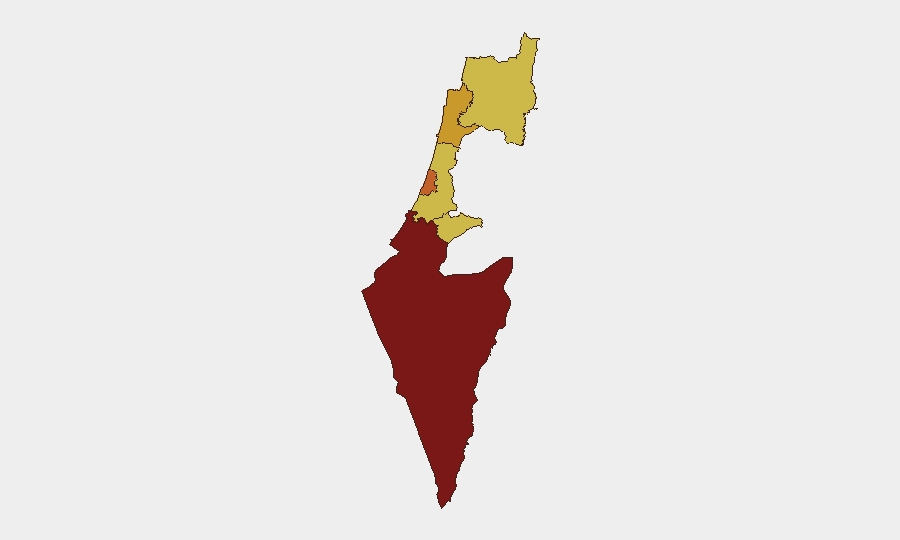
South District remains the highest-risk sub-national zone (score 100), driven by direct proximity to Gaza and active military operations; Tel Aviv, Haifa, and North districts (75–71.4) face elevated risk from rocket, UAV, and infiltration threats from Lebanon-based actors, plus ongoing domestic security incidents. Jerusalem, Center, and remaining northern areas (70–70.5) are exposed to secondary effects of the northern conflict, civil unrest, and sporadic attack vectors. The clustering of risk scores in the 70–75 range across urban centers indicates geographically dispersed threat environment rather than localized hotspot.
How GeoBit Would Assist
Security teams would prioritize AOI Monitoring & Early Warning on northern communities and border zones to detect Hezbollah attack preparations and Israeli response timelines; Conflict & Military mapping to track force deployments, casualty patterns, and operational intensity in real time; and Network & Actor Analysis to assess Hezbollah command structure, resource flows, and decision-making signals during escalation phases. Routing & Network Analysis enables alternative journey planning for personnel in Tel Aviv, Haifa, and northern districts to avoid conflict zones and interdicted routes.
7-Day Outlook
Escalation trajectory remains high-risk over the next 7 days. Absence of formal ceasefire agreement, political pressure from Israeli security ministers, and sustained Hezbollah operational capability suggest continued cross-border military activity. Risk of further Israeli strikes, retaliatory rocket/UAV attacks, and potential ground incursions into southern Lebanon is elevated; duty-of-care teams should expect operational disruptions to northern Israel transport, utilities, and business continuity through at least 2026-06-27.
Highest-Risk Areas — Ranked
| # | State / Region | Risk |
|---|---|---|
| 1 | South District | 100 |
| 2 | Tel-Aviv District | 75 |
| 3 | Haifa District | 71.4 |
| 4 | North District | 70.6 |
| 5 | Center District | 70.5 |
| 6 | Jerusalem District | 70 |
Sources
Previous Daily Briefs
A new Israel brief is written every day — each with its own risk map and downloadable CSV. Here's the last week; use the calendar to go further back.
📅 Browse every day by calendar →
Highlighted days have a brief. Tap a day for that day's map & analysis, or “csv” for that day's dataset ($5).