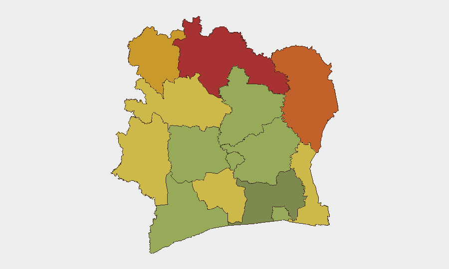
Situation Summary
Ivory Coast remains a low-threat environment globally (rank #184; composite score 2.1) with no tracked security incidents in the current reporting window. The country's risk profile is geographically concentrated in the northern and eastern border districts, where cross-border mobility, resource competition, and limited state presence create persistent vulnerability. Current conditions suggest stability in major urban centers, though seasonal hazards—particularly flooding—pose humanitarian and logistical risks nationwide.
Key Developments
Nationwide – Flooding Impact (timing not firmly constrained to last 24–48h)
Open web sources report deadly flooding across Ivory Coast with at least 59 fatalities and approximately 200 families evacuated by government response teams. Exact incident dates cannot be reliably pinned to July 5–7, 2026 from available snippets; sources refer to "recent" flooding without precise timestamps. Impact includes infrastructure disruption, displacement, and potential secondary health risks in affected areas. No specific locations or updated casualty figures from the strict last 24–48-hour window are available.
No other discrete security, conflict, civil unrest, or crime incidents with confirmed 24–48-hour dating were identified in live web research.
Most recent Ivory Coast mentions in open sources relate to international sports activity (Norway vs. Ivory Coast World Cup match in Dallas) and recurring/seasonal flood warnings rather than new security events.
Highest-Risk Areas
Northern and eastern border districts dominate the risk landscape. Savanes (78), Zanzan (75), and Denguélé (72) rank highest; all three are adjacent to Mali and Burkina Faso, where jihadist activity, pastoral conflict, and cross-border trafficking remain endemic regional concerns. Comoé (70) and Montagnes (68) follow, extending the risk corridor eastward along the Guinea and Mali borders. These districts are characterized by sparse state administration, porous borders, and seasonal migration patterns that amplify exposure to trafficking, armed group transit, and resource-driven violence. By contrast, Abidjan (45) and Lacs (48) present moderate risk, reflecting urban concentration and greater security presence.
How GeoBit Would Assist
Corporate teams should employ AOI Monitoring & Early Warning on border districts (especially Savanes, Zanzan, Denguélé) to detect militia movement, trafficking indicators, or cross-border incursions in real time. OSINT fusion (X, Telegram, regional media, SIGINT) would provide multi-language situational awareness of armed-group signaling and local conflict triggers often missed by English-language news cycles. GIS & Spatial Analysis combined with alternative route/journey planning enables duty-of-care teams to identify safe corridors and pre-position contingency logistics for personnel in northern operations or supply chains.
7-Day Outlook
Seasonal flooding risk remains elevated; teams should expect continued displacement, road interdiction, and potential disease outbreaks in low-lying areas through the rainy season. Northern border dynamics are unlikely to shift markedly absent new cross-border incidents; monitor Mali and Burkina Faso developments for contagion risk. Overall threat trajectory remains stable but weather- and infrastructure-dependent rather than security-driven over the next seven days.
Highest-Risk Areas — Ranked
| # | State / Region | Risk |
|---|---|---|
| 1 | Savanes District | 78 |
| 2 | Zanzan District | 75 |
| 3 | Denguélé District | 72 |
| 4 | Comoé District | 70 |
| 5 | Montagnes District | 68 |
| 6 | Woroba District | 65 |
| 7 | Gôh-Djiboua District | 60 |
| 8 | Sassandra-Marahoué District | 58 |
| 9 | Vallée du Bandama District | 55 |
| 10 | Bas-Sassandra District | 52 |
| 11 | Lacs District | 48 |
| 12 | Abidjan | 45 |
Sources
Previous Daily Briefs
A new Ivory Coast brief is written every day — each with its own risk map and downloadable CSV. Here's the last week; use the calendar to go further back.
📅 Browse every day by calendar →
Highlighted days have a brief. Tap a day for that day's map & analysis, or “csv” for that day's dataset ($5).
Atlas — our AI intelligence desk — emails them this snapshot personally. Nothing else, no list.