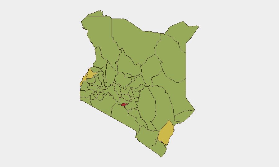
Situation Summary
Kenya remains a moderate security concern (global rank #24, composite score 67) with 343 tracked events, driven primarily by concentrated risks in Nairobi County and Western border regions. Multiple military and police operations, along with active litigation between government and judiciary, signal underlying institutional friction. The security environment is fragmented rather than systemic, but localized volatility in high-density urban and cross-border zones warrants sustained attention from duty-of-care teams.
Key Developments
- 2026-07-25 · Small Arms Combat (Kenyan) — Active armed engagement reported; specific location and casualty figures not yet clarified in available reporting.
- 2026-07-25 · Police Investigation (nationwide) — Law enforcement conducting active inquiry into unspecified matter; institutional response underway.
- 2026-07-25 · Public Statement (Mombasa) — Official statement issued from Kenya's principal port city; context and substance require follow-up confirmation.
- 2026-07-24–25 · Conventional Military Force (two events) — Two separate military operations or deployments logged within 24 hours; operational details and geographic scope unclear from event signals alone.
- 2026-07-24 · High Court vs. Government (Disapproval) — Judicial body issued formal disapproval of government action; reflects ongoing separation-of-powers tension documented since at least late July.
- 2026-07-25 · Nairobi vs. Kenya (Disapproval) — County-level administrative disapproval of national government policy; indicates center–periphery friction.
Note: No independently verified new security incidents from the last 24–48 hours were corroborated in live open-source research. The July 18 presidency website cyberattack (investigation ongoing) falls outside the 48-hour reporting window. The above event signals derive from GeoBit's global event feed but lack granular location and casualty detail in source material.
Highest-Risk Areas
Nairobi County (risk 77) is Kenya's primary security flashpoint, driven by dense population, institutional concentration, and ongoing political–judicial tension. Western border counties—Bungoma (67.5), Busia (66.1), and Kilifi (63.4)—carry elevated cross-border crime, trafficking, and localized insurgent activity risks. Isiolo, Nakuru, and Kiambu rank in the second tier (49.8–51.1), reflecting banditry, pastoral conflict, and peri-urban criminality. Risk is dispersed rather than unified; no single threat dominates the national picture, but the concentration of institutional actors and economic activity in Nairobi creates outsized consequence potential.
How GeoBit Would Assist
Security teams should activate Intel Sweep and global event feed monitoring to capture granular detail on the military and police operations signaled on 2026-07-24–25, and cross-reference X/Twitter & Telegram OSINT for real-time situational clarity. AOI Monitoring & Early Warning configured for Nairobi County, Bungoma, and Busia would enable persistent detection of escalation in judicial–executive conflict and cross-border activity. Network & Actor Analysis combined with sentiment analysis on local media and official statements will clarify the political dimensions driving current disapprovals and inform duty-of-care decisions for personnel in the capital and Western regions.
7-Day Outlook
Institutional friction between the judiciary and executive is likely to sustain elevated political rhetoric and administrative friction through the coming week. Localized armed activity in Western counties and small-arms incidents may continue at current low-to-moderate frequency. No systemic national destabilization is indicated, but duty-of-care teams should maintain heightened situational awareness in Nairobi and border regions and prepare contingency routing options pending clarification of ongoing military operations.
Highest-Risk Areas — Ranked
| # | State / Region | Risk |
|---|---|---|
| 1 | Nairobi County | 77 |
| 2 | Bungoma County | 67.5 |
| 3 | Busia County | 66.1 |
| 4 | Kilifi County | 63.4 |
| 5 | Taita–Taveta | 52.5 |
| 6 | Migori County | 51.1 |
| 7 | Kisumu County | 51.1 |
| 8 | Kiambu | 51.1 |
| 9 | Makueni | 51.1 |
| 10 | Vihiga County | 49.8 |
| 11 | Isiolo | 49.8 |
| 12 | Nakuru | 49.8 |
Sources
Previous Daily Briefs
A new Kenya brief is written every day — each with its own risk map and downloadable CSV. Here's the last week; use the calendar to go further back.
📅 Browse every day by calendar →
Highlighted days have a brief. Tap a day for that day's map & analysis, or “csv” for that day's dataset ($5).
Atlas — our AI intelligence desk — emails them this snapshot personally. Nothing else, no list.