Situation Summary
Lebanon remains in acute escalation, with a composite threat score of 84 (rank #13 globally) driven primarily by intensive Israeli military strikes and ground operations in the south. Over the past 48 hours, Israeli airstrikes have intensified sharply—144 tracked events since the baseline period, including 15 confirmed strikes, 80 airspace violations, and 447 documented projectile trajectories on 15 June alone. Ground combat between Israeli forces and Hezbollah continues near UN positions, coupled with systematic demolitions of suspected infrastructure and territorial consolidation north of the Israeli border. The trajectory is one of sustained high-intensity operations with no immediate signs of de-escalation.
Key Developments
- Southern Lebanon (multiple locations) – 15 June 2026:
UNIFIL and GeoBit Intelligence confirm 15 Israeli airstrikes, 80 airspace violations, and 447 projectile trajectories within 24 hours, representing a sharp spike compared with earlier in the week.
- Tyre, South Governorate – 13–15 June 2026:
Israeli airstrikes on residential areas killed at least 11 civilians and injured 44, with displacement orders forcing evacuation zone expansion and humanitarian mission cancellations.
- Nabatieh and surrounding localities (South & Nabatieh Governorates) – 14–15 June 2026:
Israeli forces issued new evacuation orders affecting approximately 1,900 residents across at least three localities, expanding depopulated security-buffer zones in the south.
- Southern border villages near UN positions – 14–15 June 2026:
Ground combat between Israeli forces and Hezbollah confirmed in proximity to UNIFIL positions, alongside ongoing demolition of suspected Hezbollah facilities in border-adjacent villages and territorial "clearing" near the Litani River.
- Southern Lebanon roads and access – Morning 15 June 2026:
Local authorities began reopening select roads enabling limited civilian movement, though the Lebanese Armed Forces formally advised displaced residents against returning due to continued Israeli military presence and air activity.
- Broad southern campaign – 48-hour window through 15 June 2026:
Israeli sources report strikes on more than 250 Hezbollah targets across southern Lebanon within this period, consistent with GeoBit's tracking of 94 documented security events in the current cycle.
- Ground territorial claim – Hours before 15 June 2026:
Israeli announcement of capture of an unnamed "strategic valley" in southern Lebanon as part of ongoing territorial consolidation of a security zone north of the border.
Highest-Risk Areas
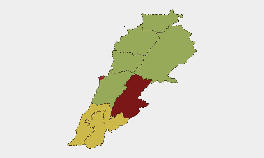
Beqaa Governorate (88.9) and Beirut Governorate (79.6) present the highest composite risk, with Beqaa driven by cross-border military activity and Beirut by proximity to command infrastructure and potential collateral impact. South Governorate (60.9) and Nabatieh Governorate (60.1) experience the most acute active threat—sustained airstrikes, ground combat, and mass displacement—making them presently the most dangerous areas for personnel or asset exposure. The remaining governorates (North, Akkar, Keserwan-Jbeil, Mount Lebanon, Baalbek-Hermel) all score 58.9, indicating elevated but slightly less intense current pressure, though all remain within active conflict dynamics.
How GeoBit Would Assist
A corporate security team with personnel or assets in Lebanon would use AOI Monitoring & Early Warning to track real-time activity in high-risk governorates (Beqaa, Beirut, South, Nabatieh) with persistent alerting on airspace violations, ground movement, and displacement orders. Routing & Network Analysis would enable rapid identification of alternative travel corridors and safe-zone reassessment as military lines shift. Conflict & Military mapping combined with Satellite & Imagery analysis would provide current force positions, infrastructure damage, and territorial control shifts to inform evacuation timing and asset relocation decisions.
7-Day Outlook
Israeli military operations are likely to sustain or intensify over the near term, with ground consolidation of southern "security zones" continuing alongside air campaigns. Civilian displacement will expand, and road access will remain unpredictable. No ceasefire signals have emerged; escalation risk remains elevated through at least the end of June.
Highest-Risk Areas — Ranked
| # | State / Region | Risk |
|---|---|---|
| 1 | Beqaa Governorate | 88.9 |
| 2 | Beirut Governorate | 79.6 |
| 3 | South Governorate | 60.9 |
| 4 | Nabatieh Governorate | 60.1 |
| 5 | North Governorate | 58.9 |
| 6 | Akkar Governorate | 58.9 |
| 7 | Keserwan-Jbeil Governorate | 58.9 |
| 8 | Mount Lebanon Governorate | 58.9 |
| 9 | Baalbek-Hermel Governorate | 58.9 |
Sources
Previous Daily Briefs
A new Lebanon brief is written every day — each with its own risk map and downloadable CSV. Here's the last week; use the calendar to go further back.
📅 Browse every day by calendar →
Highlighted days have a brief. Tap a day for that day's map & analysis, or “csv” for that day's dataset ($5).