Situation Summary
Lithuania remains at low global threat rank (#118, composite score 10) with no active tracked security events as of 11 August 2026. However, the country faces sustained low-level hybrid threats originating from Belarus and Russia, including airspace incursions and alleged Russian-linked criminal activity, alongside recent natural hazards affecting infrastructure resilience. Vilnius County carries significantly elevated risk (68) relative to the national baseline, reflecting concentration of critical national assets and cross-border exposure. The security environment is stable but requires active infrastructure hardening and threat monitoring.
Key Developments
- 08-06, Airspace Incursion (National). Suspected smuggler balloons originating from Belarus triggered an overnight operational halt and airspace closure; full infrastructure restoration was completed by end of day. Incident reflects persistent Belarus-routed cross-border probe activity.
- 08-07, Severe Windstorm (Southern Lithuania, Kaunas & Alytus Counties). Severe storms caused structural damage and felled approximately 8,000 cubic metres of timber across the south; power and transport disruptions reported. Recovery operations ongoing; no casualties confirmed.
- 08-06, GRU-Linked Arrests (Vilnius County). Lithuanian authorities charged 13 individuals in connection with alleged attempted-murder cases linked to Russian GRU networks, reflecting continuation of Russian state-sponsored criminal activity within the country.
- 48-72 Hour Alert (Critical Infrastructure). Lithuanian and Baltic officials issued public warnings of a possible Russian false-flag drone threat targeting critical infrastructure; coordinated tightening of defensive measures at LNG terminals, power links, and energy storage facilities underway in response.
Highest-Risk Areas
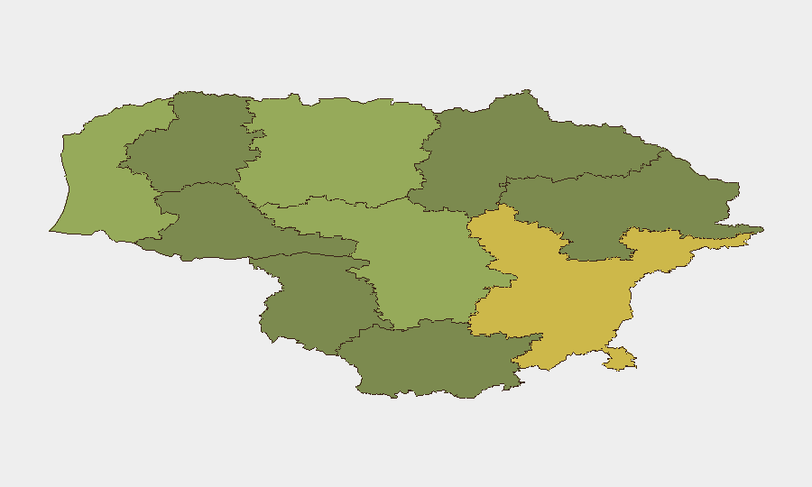
Vilnius County dominates the risk landscape (score 68), driven by concentration of national critical infrastructure, government assets, and proximity to Belarus border—a vector for hybrid threats including airspace incursions and state-sponsored criminal networks. Kaunas and Klaipeda counties (58 and 52 respectively) present secondary risk due to port operations, energy infrastructure, and transport corridors; recent storm damage in Kaunas reinforces physical vulnerability. Southern counties (Alytus, Taurage, Marijampole) remain lower-risk but are affected by weather-driven infrastructure strain and border exposure. Risk elevation is driven by hybrid-threat concentration (airspace/drone probes, criminal networks) rather than active conflict.
How GeoBit Would Assist
Intel Sweep & OSINT Fusion would track Russian state-actor signalling (social media, state media, Telegram channels) for false-flag preparation or escalation narratives; AOI Monitoring & Early Warning would maintain persistent watch on Vilnius, Kaunas, and Klaipeda critical-infrastructure zones with alert thresholds for airspace, maritime, or electrical-grid anomalies. Conflict & Military tracking would monitor Belarusian airspace activity and Russian force positioning near the border, while Routing & Network Analysis would identify resilient supply and personnel-movement alternatives for at-risk locations. Satellite & Imagery analysis would detect infrastructure damage progression post-storm and inform duty-of-care assessments.
7-Day Outlook
Airspace incursion activity and Russian false-flag signalling are likely to persist at current frequencies; no escalation to kinetic action is assessed likely in the near term. Weather recovery in southern counties will progress, though infrastructure vulnerability windows remain. Corporate and government focus should remain on infrastructure hardening and real-time threat intelligence integration.
Highest-Risk Areas — Ranked
| # | State / Region | Risk |
|---|---|---|
| 1 | Vilnius County | 68 |
| 2 | Kaunas County | 58 |
| 3 | Klaipeda County | 52 |
| 4 | Siauliai County | 42 |
| 5 | Panevezys County | 38 |
| 6 | Taurage County | 35 |
| 7 | Utena County | 33 |
| 8 | Alytus County | 32 |
| 9 | Telsiai County | 28 |
| 10 | Marijampole County | 25 |
Sources
Previous Daily Briefs
A new Lithuania brief is written every day — each with its own risk map and downloadable CSV. Here's the last week; use the calendar to go further back.
📅 Browse every day by calendar →
Highlighted days have a brief. Tap a day for that day's map & analysis, or “csv” for that day's dataset ($5).
Atlas — our AI intelligence desk — emails them this snapshot personally. Nothing else, no list.