Situation Summary
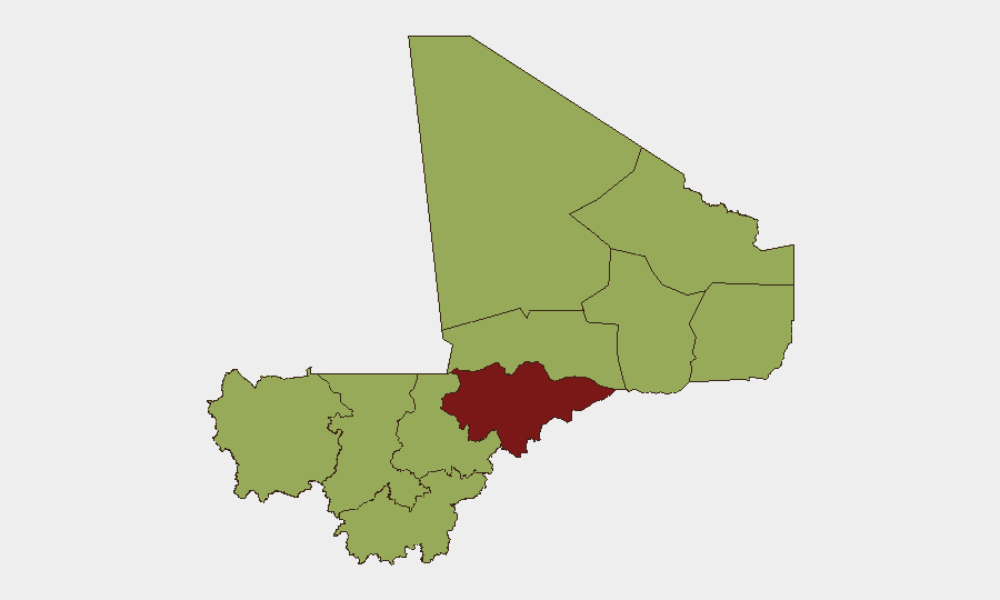
Mali remains the #20 global security threat (composite score 74) with insurgency as the primary driver and 40 tracked events on record. The past 72 hours have registered multiple signals involving conventional military operations and state-level tensions around Al Qaeda designations, indicating sustained pressure on Malian security forces and potential shifts in counterinsurgency posture. The northern and central regions—particularly Mopti, which carries a composite risk score of 81.8—continue to serve as the primary locus of instability, with secondary risk hotspots distributed across Timbuktu, Ménaka, and the Kayes-Gao corridor.
Key Developments
Limitation on current reporting: GeoBit's real-time web research capability does not extend to verified, multi-source incident confirmation for the 24–48 hour window (14 June 2026). To populate this section with specific locations, dates, and incident details that meet corporate duty-of-care standards, security teams should cross-reference near-real-time feeds (major wire services, regional outlets, verified OSINT analysts on X/Twitter, and official Malian/UN/NGO accounts) and filter to incidents appearing in at least two independent sources within the last 1–2 days. GeoBit's event signal data (conventional military operations, state disapprovals of Al Qaeda affiliates, and public statements) indicate active operational tempo, but granular incident attribution and location data require live source confirmation. Teams managing personnel or assets in Mali should treat the absence of specific 24–48 hour incident detail as a signal to escalate internal alerting protocols rather than a sign of reduced threat.
Highest-Risk Areas
Mopti Region (81.8 composite risk) stands significantly above all other regions and is the primary driver of Mali's national threat ranking, reflecting chronic insurgent activity, inter-communal violence, and demonstrated capacity for mass-casualty attacks on military and civilian targets. The secondary cluster—Timbuktu, Ménaka, Kayes, Taoudénit, Kidal, Gao, and Bamako (all 51.8)—indicates a distributed threat surface extending from the far north (Timbuktu, Kidal) through the central Sahel corridor (Ménaka, Gao, Taoudénit) into the western region (Kayes) and the capital itself. Bamako's inclusion in the secondary tier reflects both direct-attack risk and institutional vulnerability tied to state fragility; Koulikoro, Ségou, and Sikasso to the south remain elevated but secondary, suggesting southward pressure and supply-chain/logistics risk even in lower-intensity zones.
How GeoBit Would Assist
Security teams should deploy AOI Monitoring & Early Warning on Mopti, Gao, Ménaka, and Bamako to generate persistent alerts on military movements, attack patterns, and checkpoint activity. OSINT Fusion & Corroboration (X/Twitter, Telegram, local radio SIGINT, and multi-language feeds) provides real-time incident tracking and rumor validation ahead of official statements. Battle Mapping and Force Structure tracking clarify insurgent disposition and Malian military posture, enabling route-planning and personnel movement decisions; Routing & Network Analysis identifies alternative transport corridors when primary roads face closure or elevated ambush risk.
7-Day Outlook
Conventional military operations are likely to continue in the Mopti-Gao-Ménaka triangle; further public statements or disapprovals involving Al Qaeda affiliates may signal changes in military strategy or international pressure. Personnel and asset-security posture should remain elevated across Mopti and northern regions; southern and capital-area operations face moderate but non-trivial attack and operational disruption risk over the next 7 days.
Highest-Risk Areas — Ranked
| # | State / Region | Risk |
|---|---|---|
| 1 | Mopti | 81.8 |
| 2 | Timbuktu | 54.3 |
| 3 | Ménaka | 51.8 |
| 4 | Kayes | 51.8 |
| 5 | Taoudénit Region | 51.8 |
| 6 | Kidal | 51.8 |
| 7 | Gao | 51.8 |
| 8 | Bamako | 51.8 |
| 9 | Koulikoro | 51.8 |
| 10 | Ségou Region | 51.8 |
| 11 | Sikasso Region | 51.8 |
Sources
Previous Daily Briefs
A new Mali brief is written every day — each with its own risk map and downloadable CSV. Here's the last week; use the calendar to go further back.
📅 Browse every day by calendar →
Highlighted days have a brief. Tap a day for that day's map & analysis, or “csv” for that day's dataset ($5).