Situation Summary
Montenegro remains a low-threat environment globally (rank #153, composite score 6) with no tracked security events, active armed conflict, or organized unrest as of 15 August 2026. Current operational risk is dominated by active wildfires across northern and coastal regions (Nikšić, Bar, Herceg Novi, Kolašin, Ulcinj) driven by extreme heat, with localized evacuations and travel disruption but no political or security destabilization. Underlying organized crime investigations (foreign national detention in Podgorica on 11 August; armed robbery in Budva on 9 August) remain contained and do not affect national security posture. Western travel advisories maintain Montenegro at Level 1—Exercise Normal Precautions.
Key Developments
- Herceg Novi (Bijela/Baošići), night of 14–15 August: Large wildfire above the Žager area approached residential buildings, leading to evacuation of approximately 30 residents from around 50 threatened houses. Firefighters and civil protection units engaged throughout the night; fire contained but not fully extinguished as of reporting window.
- Ulcinj municipality, 14 August: Five active wildfires reported spreading through rugged terrain, complicating suppression efforts and affecting rural road access and visibility in Montenegro's southernmost municipality.
- Nikšić, Bar, Kolašin, 14–15 August: Ministry of Internal Affairs confirmed active wildfire operations across these municipalities with emergency services engaged; police issued public warnings on fire-safety violations (discarding cigarette butts from vehicles, lighting open fires) with emphasis on criminal liability.
- Bar coastal region, 15 August: Orange meteorological warning issued for extreme high temperature on Saturday 15 August, elevating wildfire risk and straining firefighting capacity already deployed across multiple zones.
- Podgorica, 11 August (background context within last 7 days): Police detained approximately 50 foreign nationals (Ukrainian, Moldovan, Slovak) in an apartment block on organized crime suspicion, seizing cash and digital equipment; investigation ongoing but represents no disruption to broader security environment.
Highest-Risk Areas
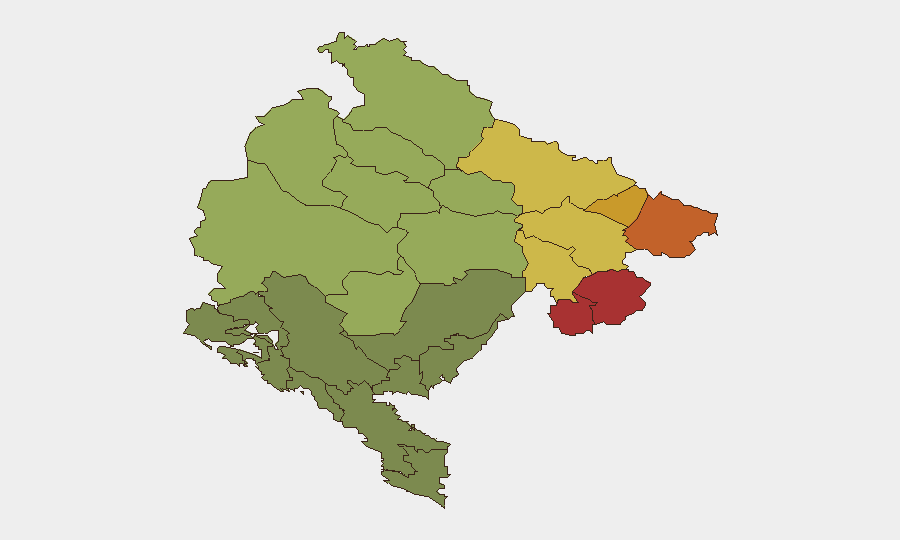
Northern and northeastern border municipalities dominate the sub-national ranking: Plav (78), Gusinje (76), Rožaje (74), Petnjica (72), and Andrijevica (68) carry substantially elevated composite scores, reflecting persistent cross-border smuggling networks, weak state capacity, and historical organized crime presence along the Serbia/Kosovo/Albania frontier. Central mountain regions (Bijelo Polje, Berane, Plužine, Pljevlja) show intermediate risk (55–65) tied to organized crime supply-route activity and remote terrain vulnerabilities. Current wildfire activity (Kolašin at 48, Žabljak at 50) adds acute but temporary safety risk to these already-stressed areas. Risk concentration in the north reflects structural conditions—not active conflict or unrest—making these zones relevant for supply-chain security and personnel transits rather than immediate violence threats.
How GeoBit Would Assist
Security teams would deploy AOI (Area of Interest) Monitoring & Early Warning on the high-risk northern municipalities to detect cross-border movement and organized crime indicators with persistent alerting; Conflict & Military network and actor analysis to map smuggling networks and assess capacity changes; and Environmental & Health monitoring to track wildfire progression, road closures, and heat-stress risks to personnel and operations. Alternative routing and journey planning via the Routing & Network Analysis capability would enable real-time re-routing around active fire zones and congested evacuation corridors.
7-Day Outlook
Wildfire activity is expected to continue through mid-to-late August given forecasted high temperatures and dry conditions, with localized evacuation risk and road disruption in affected coastal and northern zones persisting through at least 17–18 August. Organized crime investigations will remain in background; no escalation to political or security instability is anticipated. Risk profile remains stable at Level 1 unless major incident (mass casualty, infrastructure attack, or armed unrest) emerges.
Highest-Risk Areas — Ranked
| # | State / Region | Risk |
|---|---|---|
| 1 | Plav Municipality | 78 |
| 2 | Gusinje Municipality | 76 |
| 3 | Rožaje Municipality | 74 |
| 4 | Petnjica Municipality | 72 |
| 5 | Andrijevica Municipality | 68 |
| 6 | Bijelo Polje Municipality | 65 |
| 7 | Berane Municipality | 62 |
| 8 | Plužine Municipality | 58 |
| 9 | Pljevlja Municipality | 55 |
| 10 | Šavnik Municipality | 52 |
| 11 | Žabljak Municipality | 50 |
| 12 | Kolašin Municipality | 48 |
Sources
Previous Daily Briefs
A new Montenegro brief is written every day — each with its own risk map and downloadable CSV. Here's the last week; use the calendar to go further back.
- August 13, 2026
- August 11, 2026
- August 9, 2026
- August 7, 2026
- August 5, 2026
- August 4, 2026
- August 3, 2026
📅 Browse every day by calendar →
Highlighted days have a brief. Tap a day for that day's map & analysis, or “csv” for that day's dataset ($5).
Atlas — our AI intelligence desk — emails them this snapshot personally. Nothing else, no list.