Situation Summary
Niger remains a challenging security environment (global rank #23, composite threat score 68) with acute volatility concentrated in the capital and peripheral regions. A major armed assault on Niamey's principal airport on 18 June—resulting in at least 11 military and 2 civilian deaths, plus 22 attackers killed—demonstrates persistent capability and intent to strike high-value infrastructure. Concurrent diplomatic friction (government disapproval statements toward France and internal actors, AU concern) and cross-border militant activity (Al Qaeda operations reported) indicate a multidimensional threat landscape with limited short-term de-escalation signals.
Key Developments
- Niamey, Diori Hamani International Airport (18 Jun 2026): Armed gunmen attacked the airport complex at dawn, employing small arms, explosives, and armed drones. Defence ministry confirmed 11 soldiers and 2 civilians killed; 22 attackers killed and ~20 suspects arrested. Three aircraft sustained damage; assault marked the second major airport breach in 2026.
- Niamey, airport perimeter and surrounding neighbourhoods (18 Jun 2026): Security forces launched intensive sweeps after attackers dispersed into adjacent areas. Heavy military deployment reported around the airport zone with ongoing cordon operations.
- Niamey, airport access roads (18 Jun 2026): Post-attack security measures included soldier-led searches of travellers on routes to the airport, indicating elevated access controls.
- Niamey, airline operations (18 Jun 2026): Multiple commercial flights bound for Niamey were rerouted or delayed as a direct result of the assault, disrupting air transport logistics.
- Niamey, airport security zone (ongoing 18–19 Jun 2026): Regional intelligence signals indicate continued threat posture; government issued disapproval statements and the African Union issued formal concern regarding Niger's stability on 19 June.
- Cross-border militant activity (reported 19 Jun 2026): Al Qaeda operatives reported conducting unconventional violence operations linked to Nigeria, suggesting active jihadist presence in or near Niger's borders.
Highest-Risk Areas
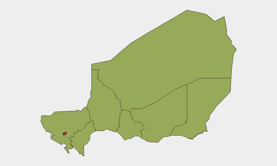
Niamey dominates the risk profile (77.9), with the 18 June airport attack providing immediate validation of urban targeting capability and critical-infrastructure vulnerability. The remaining seven regions cluster at moderate-to-elevated risk (47.9–52.4), with Agadez (52.4) representing the second-highest composite threat, likely reflecting remote geography, smuggling networks, and transnational militant activity. Diffa, Tillabéri, and peripheral zones remain persistent jihadist operational areas, though today's headline threat remains the capital's apparent susceptibility to coordinated assault on government and civilian nodes.
How GeoBit Would Assist
Corporate security teams should deploy AOI (Area-of-Interest) Monitoring & Early Warning focused on Niamey's airport, government, and expat-cluster zones to capture emerging attack signals before execution. Network & Actor Analysis combined with OSINT fusion (X/Telegram OSINT, multi-language search, entity extraction) can track militant communication and recruitment following the 18 June assault. Routing & Network Analysis enables duty-of-care teams to identify alternative travel corridors and pre-position contingency logistics in case airport closures extend or repeat.
7-Day Outlook
The airport attack likely triggers a 48–72-hour security lockdown and heightened checkpoint activity across Niamey. Government response will probably include visible military mobilization and possible temporary flight disruptions; expat and business operations should anticipate delays and access friction. No de-escalation catalyst is evident; vigilance for secondary incidents (copycat attacks, retaliatory strikes) should remain elevated through the coming week.
Highest-Risk Areas — Ranked
| # | State / Region | Risk |
|---|---|---|
| 1 | Niamey | 77.9 |
| 2 | Agadez Region | 52.4 |
| 3 | Zinder Region | 47.9 |
| 4 | Diffa Region | 47.9 |
| 5 | Tillabéri Region | 47.9 |
| 6 | Tahoua Region | 47.9 |
| 7 | Dosso Region | 47.9 |
| 8 | Maradi Region | 47.9 |
Sources
Previous Daily Briefs
A new Niger brief is written every day — each with its own risk map and downloadable CSV. Here's the last week; use the calendar to go further back.
📅 Browse every day by calendar →
Highlighted days have a brief. Tap a day for that day's map & analysis, or “csv” for that day's dataset ($5).