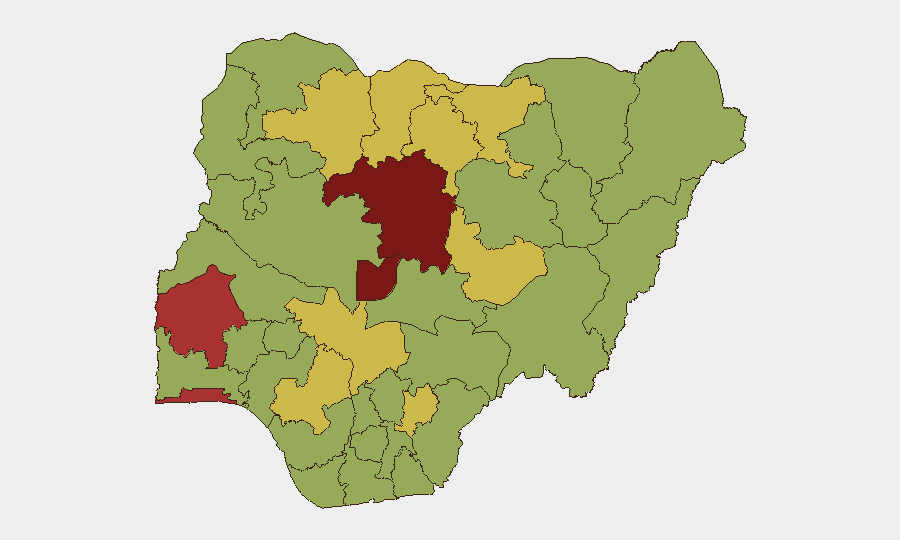
Situation Summary
Nigeria's security threat score remains elevated at #12 globally (81/100), driven primarily by active insurgency, banditry, and kidnapping across northern and central regions. The past 48 hours have seen a sharp spike in reported incidents—including an attempted breach of a strategic government institute near Jos, coordinated armed robbery in the South East, and intensified anti-bandit operations in the North West—indicating an acute operational tempo across multiple threat vectors. Official commentary on 18 June described current kidnapping and bandit activity as exceeding the combined incident rate from 2003–2010, signaling deterioration in security posture. Concurrent political friction (tensions between authorities and military leadership, expulsion of Italian diplomatic staff) adds institutional instability to an already fragmented threat environment.
Key Developments
- Kuru, Plateau State (18 June, 0100–0200 hrs approx.): Unidentified armed elements attempted to breach the perimeter fence of the National Institute for Policy and Strategic Studies (NIPSS). Internal and external security forces repelled the intrusion within approximately one hour; no casualties or abductions reported. Incident highlights targeting of critical government infrastructure in central Nigeria.
- Owerri, Imo State (night of 18 June): At least six armed robbers conducted coordinated raids on seven residential flats in an Owerri estate, making off with valuables. Incident captured on CCTV and amplified across social media crime-watch networks, indicating organized urban crime activity in the South East.
- Zamfara/Katsina States (18 June reporting, covering 24–48h operations): Regional authorities announced new executive orders banning jerrycan fuel sales and closing informal fuel distribution points to disrupt bandit logistics. Operations under Operation Hadarin Daji continue; recent rescues included kidnap victims Amina Rabiu Abubakar and others. Reflects escalation in anti-bandit enforcement across the North West.
- Northern Nigeria multi-state (18 June analyst briefing): Security commentators noted that incident volume (kidnappings, insurgency, bandit attacks) over the past 14 days exceeds the 2003–2010 combined total, with acute spikes reported across northern corridors. Indicates sustained high-tempo criminal and militant activity.
- Borno State (reported 18 June, timeline ~recent): Military sources confirmed release of hundreds of Boko Haram kidnap victims; hundreds remain in captivity. Underscores active conflict dynamics and persistent abduction risk in the North East.
- National (18 June policy statement): Inspector-General of Police Kayode Egbetokun Disu announced state police creation will not dissolve federal roles but transition current force into a Federal Police Service. Institutional reform signals ongoing security restructuring amid operational strain.
Highest-Risk Areas
Kaduna State (87) and the Federal Capital Territory (80.5) dominate the sub-national ranking, followed by Oyo, Lagos, Zamfara, Katsina, and Jigawa. The concentration of risk in the North West (Zamfara, Katsina, Jigawa) and North Central (Kaduna, Plateau, Kogi) reflects active bandit networks, kidnapping economies, and militant operations; the elevated FCT and Lagos scores indicate spillover urban crime and kidnapping-for-ransom targeting high-value individuals and business assets. Plateau State's inclusion in the top 12 is reinforced by the NIPSS breach attempt, confirming critical infrastructure as a live threat vector in central Nigeria.
How GeoBit Would Assist
Security teams managing personnel or assets across Nigeria should deploy AOI (Area-of-Interest) Monitoring & Early Warning on Kaduna, FCT, and North West corridors for real-time breach and incident alerting; use Routing & Network Analysis to identify lower-risk travel alternatives for staff and supply chains; and conduct OSINT fusion & corroboration (X/Twitter, Telegram, local media feeds) to distinguish operational threats from social media amplification of crime. Conflict & Military mapping and Network & Actor Analysis will clarify state-level bandit and insurgent cell activity to support risk-based duty-of-care decisions.
7-Day Outlook
The 14-day incident surge and reported spike in kidnappings suggest operational momentum among northern bandit networks and insurgent cells is sustaining or accelerating. Expect continued high-tempo activity in Kaduna, Katsina, and Zamfara; urban crime in Lagos and Abuja will likely persist. Political friction between civilian and military leadership may constrain coordinated response effectiveness in the near term.
Highest-Risk Areas — Ranked
| # | State / Region | Risk |
|---|---|---|
| 1 | Kaduna State | 87 |
| 2 | Federal Capital Territory | 80.5 |
| 3 | Oyo State | 77.7 |
| 4 | Lagos State | 76.1 |
| 5 | Zamfara State | 64.4 |
| 6 | Katsina State | 63.4 |
| 7 | Jigawa State | 63 |
| 8 | Edo State | 62.2 |
| 9 | Plateau State | 61.8 |
| 10 | Kogi State | 61.6 |
| 11 | Kano State | 60.8 |
| 12 | Ebonyi State | 60.4 |
Sources
Previous Daily Briefs
A new Nigeria brief is written every day — each with its own risk map and downloadable CSV. Here's the last week; use the calendar to go further back.
📅 Browse every day by calendar →
Highlighted days have a brief. Tap a day for that day's map & analysis, or “csv” for that day's dataset ($5).