Situation Summary
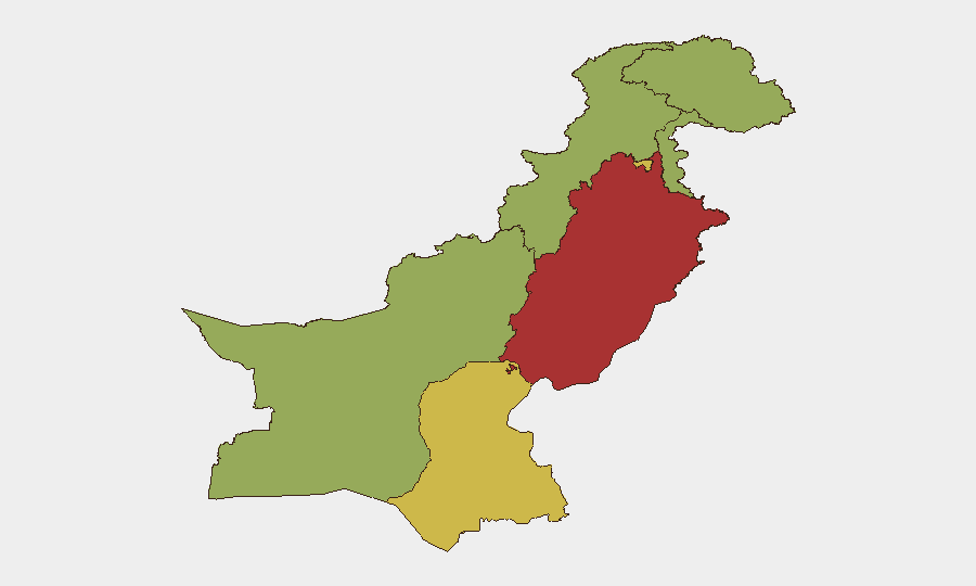
Pakistan remains at composite threat score 69 (rank #34 globally), with insurgency as the primary driver across 720 tracked events. Sub-national risk is heavily concentrated in Punjab (78.4) and Islamabad Capital Territory (67.5), with secondary concern across Sindh, Azad Kashmir, and the northwestern border regions. Recent event signals point to a mixture of state security operations, small-arms engagements, and environmental/conservation-related political friction; the overall trajectory suggests sustained operational tempo by security forces against armed actors, without immediate indicators of a major escalation.
Key Developments
Signal Limitation: GeoBit's live web research capability is currently offline for this brief. The event signals listed above (dated 2026-06-12 to 2026-06-14) indicate recent activity, but specific locations, casualty counts, and operational outcomes cannot be reliably verified without access to near-real-time news wires (Reuters, AP, AFP), official Pakistan Army ISPR statements, provincial police X accounts, or on-the-ground journalist reporting from Karachi, Lahore, Islamabad, Peshawar, and Quetta.
To produce 5–8 actionable, location-specific incident bullets for the last 24–48 hours, the security team should:
- Supply recent headline links, X posts, or alert feeds (GDELT, ACLED, LUAM, or internal vendor streams);
- Confirm which of the June 12–14 signals (military operations, small-arms combat near Iran border, public statements in Karachi) have been corroborated and where;
- Clarify the nature of June 12 government rejection and conservationist statements (policy, infrastructure, or security-related).
Once sourced, GeoBit will structure these into location-dated bullets with risk implications.
Highest-Risk Areas
Punjab and Islamabad Capital Territory dominate the risk profile, driven by population density, transport networks, and operational intensity by both state and non-state actors. Sindh (62.6) remains volatile, with Karachi (Pakistan's largest city) a persistent flashpoint for criminal-militant nexus activity and sectarian tensions. The northwestern tier—Azad Kashmir, Khyber Pakhtunkhwa, and Balochistan—registers sustained elevated risk from cross-border insurgency, tribal conflict, and separatist activity, particularly along the Iran and Afghanistan borders. Gilgit-Baltistan, though lower-ranked (49.7), warrants monitoring due to geopolitical sensitivity and seasonal access constraints.
How GeoBit Would Assist
Security teams should deploy AOI Monitoring & Early Warning on high-footprint locations (corporate offices, warehouses, residences in Punjab, Islamabad, and Karachi) to detect credible threat signals in real time. Network & Actor Analysis combined with Conflict & Military mapping will track non-state armed group activity, state counter-insurgency operations, and cross-border spillover from Afghanistan and Iran. Routing & Network Analysis supports contingency planning and safe-passage route selection for personnel moves in high-risk provinces, while multi-language OSINT fusion (X, Telegram, local media) ensures 24-hour situational awareness independent of mainstream English-language feeds.
7-Day Outlook
Expect continued security-force operations in Punjab and KP, with periodic tactical engagements and public statements reflecting political/policy tensions (as evidenced by June 12–14 signals). No major strategic shift or ceasefire announcement is currently signaled; routine travel and infrastructure risk should be assumed elevated in Punjab, Islamabad, and Karachi through end-June. Personnel in Balochistan and border areas (KP) face compounded cross-border volatility; supply-chain and movement planning should factor multi-day delays.
Highest-Risk Areas — Ranked
| # | State / Region | Risk |
|---|---|---|
| 1 | Punjab | 78.4 |
| 2 | Islamabad Capital Territory | 67.5 |
| 3 | Sindh | 62.6 |
| 4 | Azad Kashmir | 57.6 |
| 5 | Balochistan | 54.5 |
| 6 | Khyber Pakhtunkhwa | 54.3 |
| 7 | Gilgit-Baltistan | 49.7 |
Previous Daily Briefs
A new Pakistan brief is written every day — each with its own risk map and downloadable CSV. Here's the last week; use the calendar to go further back.
📅 Browse every day by calendar →
Highlighted days have a brief. Tap a day for that day's map & analysis, or “csv” for that day's dataset ($5).