Situation Summary
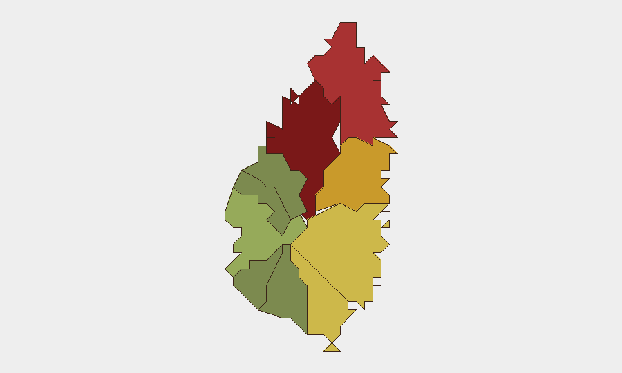
Saint Lucia remains classified as a composite threat level 14 globally, with no discrete tracked security events in the current reporting window. The underlying security environment is shaped by persistent violent crime—armed robbery, assault, burglary, and rape—which prompted a U.S. State Department Level 2 travel advisory update on July 10, 2026. The capital region and northern parishes present markedly higher risk than southern and western zones, reflecting concentrated crime activity and gang-related violence over recent months.
Key Developments
No verifiable, timestamped security or civil unrest incidents have been confirmed in Saint Lucia during the last 24–48 hours across open-source, social media, or monitored news feeds. The most recent formally dated advisory or incident update is the U.S. State Department travel advisory revision (July 10, 2026), which falls outside the immediate 24–48 hour window but reflects the current threat posture. Open-source crime reporting and police investigations remain active (e.g., ongoing murder investigations and apprehensions), but no specific new incidents with confirmed dates in the last two days are available. Absence of reported events does not indicate absence of risk; rather, daily crime and gang activity in high-risk parishes continues below headline threshold.
Highest-Risk Areas
Castries (risk 95) and Gros Islet (risk 78) drive the majority of mapped risk, followed by Dennery (72), Vieux Fort (68), and Micoud (65). These parishes are characterized by gang rivalry, drug trafficking activity, and localized violence affecting residents, workers, and transient populations. Castries—the capital and economic hub—concentrates risk due to population density, nightlife venues, and informal-economy activity; Gros Islet (tourism and entertainment district) presents secondary concentration risk to visitors and hospitality staff. By contrast, southern and western parishes (Canaries, Choiseul, Anse La Raye) report substantially lower composite scores, indicating lower frequency or severity of tracked incidents. Risk distribution reflects historical crime patterns and socioeconomic conditions rather than current escalation.
How GeoBit Would Assist
Security teams with personnel or assets in Saint Lucia would deploy AOI Monitoring & Early Warning on Castries and Gros Islet to track real-time incident emergence and receive alerts on crime spikes or civil unrest. Intel Sweep and OSINT fusion (X/Twitter, local news feeds, police reports) would provide multi-source corroboration of incidents, timely enough to inform duty-of-care decisions for staff movement and facility operations. Risk & Threat Assessment and Sentiment & Temporal Analysis would distinguish signal from noise in crime reporting, isolating genuine, location-specific threats from background chatter and historical references.
7-Day Outlook
Violent crime in high-risk parishes is expected to remain at current baseline frequency absent major external shocks or gang escalations. No indication of imminent political instability, infrastructure disruption, or mass civil unrest exists. Continued reliance on open-source monitoring and real-time alerting is warranted to detect any deviation from this pattern.
Highest-Risk Areas — Ranked
| # | State / Region | Risk |
|---|---|---|
| 1 | Castries | 95 |
| 2 | Gros Islet | 78 |
| 3 | Dennery | 72 |
| 4 | Vieux Fort | 68 |
| 5 | Micoud | 65 |
| 6 | Soufrière | 42 |
| 7 | Laborie | 38 |
| 8 | Choiseul | 35 |
| 9 | Anse La Raye | 28 |
| 10 | Canaries | 12 |
Sources
Previous Daily Briefs
A new Saint Lucia brief is written every day — each with its own risk map and downloadable CSV. Here's the last week; use the calendar to go further back.
📅 Browse every day by calendar →
Highlighted days have a brief. Tap a day for that day's map & analysis, or “csv” for that day's dataset ($5).
Atlas — our AI intelligence desk — emails them this snapshot personally. Nothing else, no list.