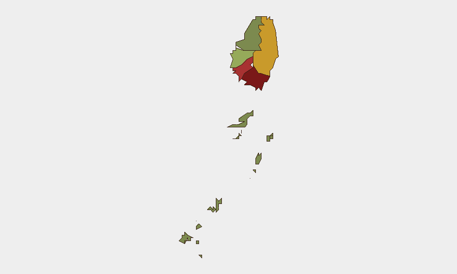
Situation Summary
Saint Vincent ranks #173 globally with a composite threat score of 3, indicating low-to-moderate risk at the national level. However, violent crime—particularly gun homicides—remains the primary security concern, with four confirmed fatal incidents recorded between 1–6 August across multiple parishes. The geographic concentration of risk in Saint George, Saint Andrew, and Charlotte parishes reflects persistent localized gang and interpersonal violence rather than systemic instability or organized-crime expansion.
Key Developments
- Rockies, Saint George — 6 August 2026 — Akeem Ferdinand, recently released from prison, was shot dead inside a residence. Police had not issued a full public statement at time of local reporting; circumstances remain under investigation.
- Mesopotamia, Saint Andrew — 4 August 2026 — Michael Jackson (52, labourer from Yambou) was fatally shot by police during an incident; the shooting remains under investigation and has not been formally classified.
- North Windward / Dickson Village area — 1 August 2026 — Clydon Cato was found dead with apparent gunshot wounds. On 6 August, Rhyse Henry was charged with murder and remanded in custody.
- Multiple parishes, 1–6 August — Three confirmed homicides within a six-day window indicate a localized spike in violent-crime incidents, though no discrete organized-crime territorial conflict or gang warfare has been reported.
No significant developments were independently verified in the 24 hours immediately preceding 8 August 2026.
Highest-Risk Areas
Saint George (risk 92), Saint Andrew (risk 78), and Charlotte (risk 71) account for the substantial majority of tracked risk and are consistent with locations of recent fatal incidents. Saint George's concentration reflects both urban density (Kingstown area) and historic gang-activity corridors; Saint Andrew encompasses Mesopotamia and surrounding agricultural parishes where rural and periurban crime overlaps. Charlotte's elevation likely reflects similar interpersonal-violence patterns. Saint Patrick, David, and the Grenadines pose minimal current risk (58, 34, and 12 respectively), suggesting risk is sharply geographically bounded rather than nationwide.
How GeoBit Would Assist
Organizations with personnel or assets in Saint Vincent should employ AOI Monitoring & Early Warning on high-risk parishes (Saint George, Saint Andrew, Charlotte) to flag incident clusters and temporal patterns in real time. Intel Sweep and X/Twitter OSINT, cross-referenced with local news outlets, provide rapid corroboration of emerging crime incidents and gang-related activity before formal police statements. Network & Actor Analysis would map relationships between known offenders and locations to anticipate secondary risk to corporate or expatriate communities, while GIS & Spatial Analysis can identify safe routes and temporal windows for essential movements in affected parishes.
7-Day Outlook
No specific threat event or escalation is forecast for the next seven days. The current elevated violent-crime activity appears reactive and localized rather than indicative of organized territorial conflict or destabilization. Continued monitoring of police statements, court remands, and local reporting is warranted to detect any shift toward gang retaliation or coordinated criminal activity; absent such signals, risk should stabilize at current baseline levels.
Highest-Risk Areas — Ranked
| # | State / Region | Risk |
|---|---|---|
| 1 | Saint George | 92 |
| 2 | Saint Andrew | 78 |
| 3 | Charlotte | 71 |
| 4 | Saint Patrick | 58 |
| 5 | Saint David | 34 |
| 6 | Grenadines | 12 |
Sources
- security.gov.vc
- onenewsstvincent.com
- stvincenttimes.com
- onenewsstvincent.com
- news.stv.tv
- onenewsstvincent.com
- geobit.ai
- stluciatimes.com
- gov.vc
- nbcsvg.com
- nbcsvg.com
- caribbeannationalweekly.com
- unitedpacstlucia.com
- virginislandsnewsonline.com
- virginislandsnewsonline.com
- flights.virginatlantic.com
- noonsite.com
- geobit.ai
Previous Daily Briefs
A new Saint Vincent brief is written every day — each with its own risk map and downloadable CSV. Here's the last week; use the calendar to go further back.
📅 Browse every day by calendar →
Highlighted days have a brief. Tap a day for that day's map & analysis, or “csv” for that day's dataset ($5).
Atlas — our AI intelligence desk — emails them this snapshot personally. Nothing else, no list.