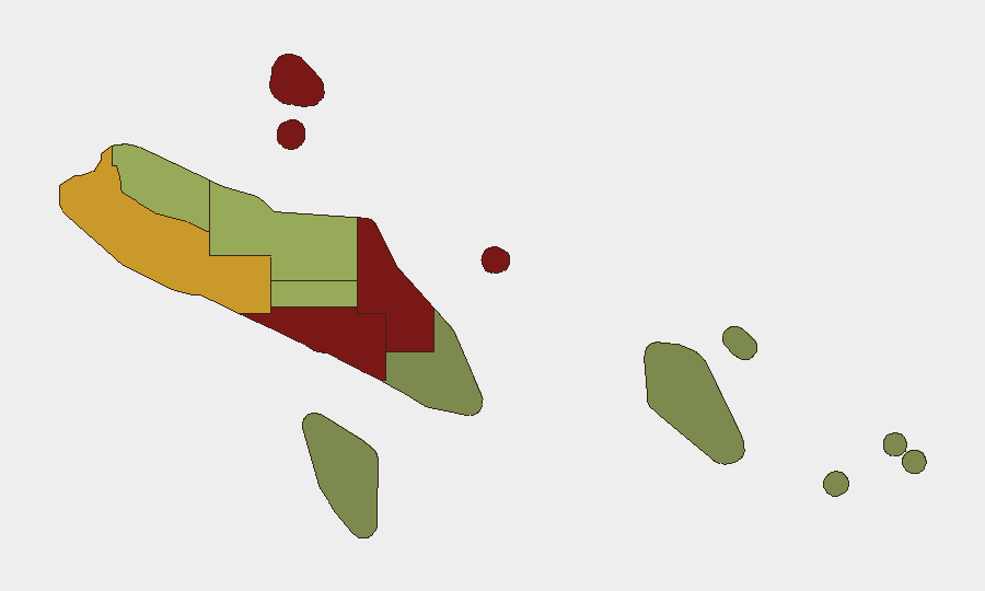
Situation Summary
Solomon Islands faces a composite security threat score of 5 with two tracked events in the current monitoring cycle. No verified security incidents have been reported in the last 24–48 hours; transport, port, and airport operations remain normal nationwide. However, underlying conditions in Honiara and Central Guadalcanal—persistent violent crime, economic disruption, and community frustration with police capacity—sustain elevated risk in urban centers, particularly in the capital region.
Key Developments
- Nationwide (21 Jul 2026) — Official security reporting confirms no verified security incidents in the preceding 24–48 hours; all transport and port infrastructure operating normally.
- Honiara / Washington (21 Jul 2026) — Solomon Islands Prime Minister Jeremiah Manele concluded meetings with U.S. officials, agreeing to deepen maritime cooperation and advance a ship rider agreement scheduled for the following week. This represents a security-development and diplomatic engagement, not an incident.
- Central Guadalcanal (recent, exact date unconfirmed) — Local reporting indicates residents and MPs have called for increased police presence following a reported surge in violent crime, including assaults and an incident involving a logging vehicle set ablaze by masked individuals.
- Belaha, Central Guadalcanal (recent, exact date unconfirmed) — Police are investigating arson linked to a burned dump truck and have increased patrols after multiple reported incidents; the Solomon Islands Chamber of Commerce has condemned attacks in the area, citing impacts on business confidence and tourism.
- Regional context (recent, exact date unconfirmed) — Solomon Islands has joined other Pacific states in criticizing a Chinese ballistic-missile test. While geopolitical in nature, this reflects regional security sensitivities and may influence bilateral relationships affecting Solomon Islands stability and external security cooperation.
Highest-Risk Areas
Honiara (risk 92) and Guadalcanal (risk 88) account for the largest share of assessed threat. Both are driven by persistent violent crime, property crime, and economic stress in urban and semi-urban zones, compounded by reported gaps in police capacity and community trust. Malaita (risk 85) and Western Province (risk 72) remain elevated, likely reflecting underlying governance challenges and historical inter-communal tensions. Remaining provinces show substantially lower risk profiles, with Temotu (risk 18) and Rennell and Bellona (risk 22) representing minimal current threat indicators.
How GeoBit Would Assist
For corporations and duty-of-care teams with personnel or assets in Solomon Islands, GeoBit's AOI Monitoring & Early Warning capability would provide persistent surveillance of Honiara and Central Guadalcanal, with automated alerting on changes in crime patterns, political activity, or infrastructure disruption. Intel Sweep and multi-language OSINT fusion would track local reporting, police statements, and community sentiment in real time across Telegram, local news outlets, and social media to detect emerging flashpoints before escalation. Routing & Network Analysis would enable security teams to identify and update safe travel corridors and alternative routes for staff movement in high-risk provinces.
7-Day Outlook
No imminent escalation is forecast for the next seven days. Absent fresh incident reporting, the security environment is expected to remain stable at current baseline levels, with normal commercial and transport operations continuing. However, underlying crime and economic pressures in Honiara and Guadalcanal warrant sustained monitoring; any sudden spike in violent crime, political rhetoric, or police incidents should be treated as a potential leading indicator of broader instability.
Highest-Risk Areas — Ranked
| # | State / Region | Risk |
|---|---|---|
| 1 | Honiara | 92 |
| 2 | Guadalcanal | 88 |
| 3 | Malaita | 85 |
| 4 | Western | 72 |
| 5 | Choiseul | 58 |
| 6 | Isabel | 52 |
| 7 | Central Province | 48 |
| 8 | Makira-Ulawa | 38 |
| 9 | Rennell and Bellona | 22 |
| 10 | Temotu | 18 |
Sources
Previous Daily Briefs
A new Solomon Islands brief is written every day — each with its own risk map and downloadable CSV. Here's the last week; use the calendar to go further back.
📅 Browse every day by calendar →
Highlighted days have a brief. Tap a day for that day's map & analysis, or “csv” for that day's dataset ($5).
Atlas — our AI intelligence desk — emails them this snapshot personally. Nothing else, no list.