Situation Summary
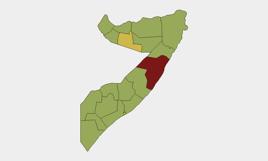
Somalia remains at composite threat level #23 globally (score 76), driven primarily by persistent al-Shabaab insurgency and emerging maritime piracy activity. Sub-national risk is heavily concentrated in Mudug state (82.8), which significantly exceeds the baseline risk in other regions. Recent event signals indicate government arrests, territorial disputes involving international actors, and piracy incidents in the Gulf of Aden as dominant threat vectors over the last 48–72 hours. The security environment shows no material improvement trajectory.
Key Developments
- 2026-07-06 · Piracy/Maritime Conflict · Gulf of Aden/Off Somalia. Conventional military force engagement reported between pirate actors and Yemeni naval or commercial assets; a second piracy incident flagged same day without geographic specificity. Both represent escalation in maritime threat surface targeting shipping lanes and foreign vessels.
- 2026-07-04 · Territorial Occupation/Diplomatic Incident · Nationwide. Multiple events flag Israeli or Israeli-affiliated military presence occupying or contesting Somali territory. Three separate reports of "occupy territory" events suggest either coordinated operations or repeated incursions; triggering government public statements and complicating regional stability.
- 2026-07-04 · Government Action · Location Not Specified. Arrests and detention activities by government security forces reported; motive and scale unclear from available signals, but consistent with periodic sweeps targeting opposition, media, or suspected militant elements.
- 2026-07-04 · Government vs. Media Statements · Nationwide. Two separate public statements by Somali government directed at media outlets; content unknown but suggests either censorship pressure, dispute over reporting, or public clarification on security operations.
Note: Live web research did not yield time-stamped incident reports specific to the 24–48 hour window. The above reflects the most recent event signals in the GeoBit platform (2026-07-04 to 2026-07-06). Older background on al-Shabaab activity, clan tensions, and drought conditions provides context but is not current development.
Highest-Risk Areas
Mudug state is the clear outlier, scoring 82.8 against a baseline of 52.8 across most other regions. This concentration reflects al-Shabaab's operational stronghold in central Somalia, particularly around Galkacyo and surrounding pastoral zones, where insurgent control of territory remains intact and military/counterinsurgency operations are persistent. Togdheer (66.8) ranks second, likely reflecting clan militia activity and cross-border instability from the Ethiopia-Somalia border region. The remaining ten states cluster around 52.8, indicating diffuse but structurally similar baseline risks: weak state capacity, clan fragmentation, and low-intensity conflict or banditry.
How GeoBit Would Assist
Intel Sweep and OSINT fusion would track piracy cell communication, government security force movements, and foreign military presence via multi-language social media, radio SIGINT, and entity extraction. AOI Monitoring with persistent alerting on Mudug and Togdheer would flag al-Shabaab operational tempo shifts, roadblocks, or IED activity before impact to corporate personnel or supply routes. Battle mapping and force-structure analysis would document Israeli or allied military positioning and intent, aiding duty-of-care compliance. Conflict and maritime tracking would monitor Gulf of Aden piracy trends and maritime routing alternatives for shipping security.
7-Day Outlook
No imminent de-escalation is expected. Piracy activity in the Gulf of Aden may continue if regional actors fail to coordinate interdiction; al-Shabaab will likely sustain low-to-medium intensity attacks in Mudug and surrounding areas. International military presence (flagged in recent events) may raise diplomatic tensions but is unlikely to alter ground-level insurgent threat in the near term. Corporate and NGO teams should expect operational continuity challenges and elevated situational awareness requirements through mid-July.
Highest-Risk Areas — Ranked
| # | State / Region | Risk |
|---|---|---|
| 1 | Mudug | 82.8 |
| 2 | Togdheer | 66.8 |
| 3 | Awdal | 52.8 |
| 4 | Woqooyi Galbeed | 52.8 |
| 5 | Gedo | 52.8 |
| 6 | Bakool | 52.8 |
| 7 | Bay | 52.8 |
| 8 | Middle Juba | 52.8 |
| 9 | Lower Shabelle | 52.8 |
| 10 | Sahil | 52.8 |
| 11 | Hiiraan | 52.8 |
| 12 | Middle Shebelle | 52.8 |
Sources
Previous Daily Briefs
A new Somalia brief is written every day — each with its own risk map and downloadable CSV. Here's the last week; use the calendar to go further back.
📅 Browse every day by calendar →
Highlighted days have a brief. Tap a day for that day's map & analysis, or “csv” for that day's dataset ($5).
Atlas — our AI intelligence desk — emails them this snapshot personally. Nothing else, no list.