Situation Summary
South Sudan remains fragmented along sub-national fault lines, with composite national threat score of 64 (rank #32 globally) masking acute regional volatility, particularly in the oil-rich north and pastoral east. The country continues to experience residual armed-group activity and intercommunal violence following the 2018 ceasefire agreement, with limited state capacity to project authority outside Juba. No major escalations were recorded in the past 24–48 hours, but reported armed movement in Jonglei State on 5 July underscores persistent risk of localized clashes and displacement in high-threat zones.
Key Developments
- Walgak town, Akobo County, Jonglei State – 5 July 2026
SPLA-IO forces reported to have recaptured Walgak following armed engagement; social-media reporting indicates political reaction from SPLA-IG leadership. Unconfirmed by independent sources; signals active armed-group maneuver and potential for further clashes and movement restrictions in Akobo County.
- Juba, Ministry of Foreign Affairs – 5 July 2026
Routine diplomatic engagement (South Sudan–African Union relations) conducted by Director General of Protocol. Indicates normal government functioning in central Juba; no security incident reported.
- No additional discrete security events recorded in the last 24–48 hours with reliable cross-confirmation in open sources. Current web coverage of South Sudan remains limited; social-media sourcing dominates available reporting and carries verification risk.
Highest-Risk Areas
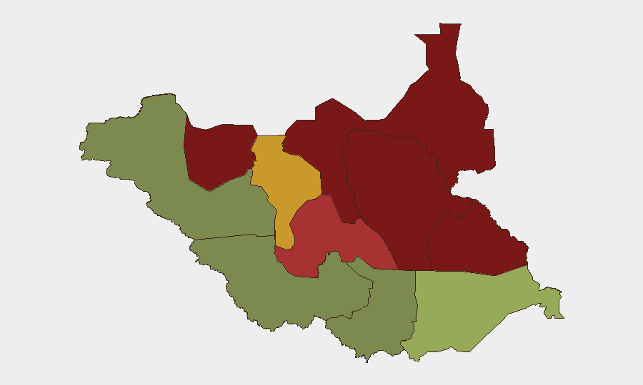
Unity State (risk 95) and Jonglei State (risk 93) drive the national risk profile, followed by Upper Nile (88) and Greater Pibor Administrative Area (87). These four states—concentrated in the oil-producing north and pastoral east—account for armed-group presence, intercommunal violence, weak state control, and restricted humanitarian access. Northern Bahr el Ghazal (82) and Lakes State (78) remain elevated due to pastoralist conflict and resource competition. By contrast, Central Equatoria (35) and Western Bahr el Ghazal (28), anchored by Juba, carry substantially lower composite risk. Organizations with personnel or assets in Unity, Jonglei, or Upper Nile face materially higher exposure to armed confrontation, displacement, and supply-chain disruption.
How GeoBit Would Assist
Security teams should deploy AOI Monitoring & Early Warning on high-risk state capitals (Bentiu, Bor, Malakal) and commercial hubs to detect armed movement, displacement patterns, and access degradation in near-real time. Conflict & Military tracking (force structure, weapons capability, battle mapping) combined with OSINT fusion (social media, local radio, Telegram networks) enables rapid corroboration of reports like the Walgak incident and forecast of secondary effects (checkpoint establishment, supply-route closure). Routing & Network Analysis supports duty-of-care teams in identifying alternative travel corridors and assessing safe passage windows in high-threat corridors between Juba and field locations.
7-Day Outlook
No imminent nationwide escalation is evident; however, localized armed clashes in Unity, Jonglei, and Upper Nile are likely to persist at current tempo. Rainy season (May–November) typically restricts road access and increases reliance on air transport; organizations should anticipate logistical delays and periodic movement restrictions in the north. Risk posture should remain heightened in top-five risk states, with contingency planning for rapid personnel evacuation or relocation if armed activity intensifies near critical infrastructure or populated centers.
Highest-Risk Areas — Ranked
| # | State / Region | Risk |
|---|---|---|
| 1 | Unity | 95 |
| 2 | Jonglei | 93 |
| 3 | Upper Nile | 88 |
| 4 | Greater Pibor Administrative Area | 87 |
| 5 | Northern Bahr el Ghazal | 82 |
| 6 | Lakes | 78 |
| 7 | Warrap | 72 |
| 8 | Ruweng Administrative Area | 68 |
| 9 | Eastern Equatoria | 52 |
| 10 | Western Equatoria | 38 |
| 11 | Central Equatoria | 35 |
| 12 | Western Bahr el Ghazal State | 28 |
Previous Daily Briefs
A new South Sudan brief is written every day — each with its own risk map and downloadable CSV. Here's the last week; use the calendar to go further back.
📅 Browse every day by calendar →
Highlighted days have a brief. Tap a day for that day's map & analysis, or “csv” for that day's dataset ($5).
Atlas — our AI intelligence desk — emails them this snapshot personally. Nothing else, no list.