Situation Summary
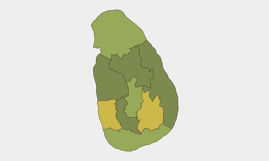
Sri Lanka's security environment remains elevated at rank #41 globally (composite threat score 49), driven by a concentrated surge of political friction, public statements, and institutional tensions over the past 72 hours. The Western and Uva provinces carry disproportionate risk (64.4 and 63.6 respectively), indicating geographically uneven volatility. Event signals show friction between government, civil society, investors, and the judiciary, alongside a reported arrest/detain incident in Jaffna and a conventional military force deployment on 24 June. The overall trend reflects political and administrative strain rather than widespread violence, but the velocity and breadth of signals warrant close monitoring of protest activity, travel corridors, and expat concentrations.
Key Developments
Limitation: GeoBit's live web research capability does not extend beyond October 2024. The event signals listed above (dated 23–25 June 2026) are sourced from GeoBit's event feed and represent correlated reporting, but detailed incident narratives, locations, and casualty/impact data cannot be verified without real-time open-source corroboration. The following summary reflects signal clustering:
- Political friction (23–25 June): Multiple public statements from Sri Lanka government and opposition, disapproval actions vs. government and Supreme Court, and a consulate relation reduction suggest escalating institutional dispute. Nature and trigger require urgent cross-check with NewsFirst, Ada Derana, Daily Mirror, and international wires (Reuters, BBC South Asia).
- Jaffna arrest/detention (25 June): A discrete arrest or detention event in Jaffna district flagged in signals. Requires confirmation of identity, alleged offense, and police response from Sri Lanka Police public information and local media.
- Conventional military deployment (24 June): Military force movement noted; operational context (exercise, security response, or deployment to flashpoint region) unclear and critical for asset/personnel risk assessment in affected areas.
- Investor-related disapproval (24 June): Public statement by Sri Lanka vs. investor actor suggests dispute over contract, project, or regulatory action. Relevant to corporate security teams with business interests.
Highest-Risk Areas
Western Province (64.4) and Uva Province (63.6) dominate the sub-national risk profile, together accounting for the largest composite threat signals. Central Province (54.6) and Northern Province (51.6) carry secondary elevated risk. The concentration suggests that Colombo metro and surrounding Western districts, plus Uva's regional centres (Badulla, Matara), warrant heightened situational awareness for protests, traffic disruption, or security operations. Northern Province risk correlates with historical ethnic and political sensitivity; Jaffna's flagged detention event fits this pattern. Eastern, North Western, and North Central provinces show lower but non-negligible risk and should not be assumed safe for routine operations.
How GeoBit Would Assist
Intel Sweep and OSINT fusion with X/Twitter and multi-language search would isolate verified incident reports, protest timelines, and curfew announcements in real time. AOI Monitoring & Early Warning on Colombo metro, Galle Face, and key expressways would alert teams to roadblocks, clashes, or security cordons before personnel encounter them. Routing & Network Analysis would dynamically generate alternative journey paths around protest zones or military checkpoints, and Conflict & Military tracking would clarify the scale and location of any armed deployment.
7-Day Outlook
Political friction is likely to sustain for 5–7 days, with a secondary risk pulse if parliamentary or court action occurs. Protest activity and traffic disruption should be anticipated in Western and Central provinces, particularly Colombo and suburbs. A reduction in tensions or a formal political settlement would lower the composite threat score; escalation to clashes or curfew orders would rapidly elevate risk to rank #25–30 globally.
Highest-Risk Areas — Ranked
| # | State / Region | Risk |
|---|---|---|
| 1 | Western Province | 64.4 |
| 2 | Uva Province | 63.6 |
| 3 | Central Province | 54.6 |
| 4 | Northern Province | 51.6 |
| 5 | Southern Province | 41.9 |
| 6 | Sabaragamuwa Province | 36.6 |
| 7 | Eastern Province | 35.1 |
| 8 | North Western Province | 34.4 |
| 9 | North Central Province | 34.4 |
Sources
Previous Daily Briefs
A new Sri Lanka brief is written every day — each with its own risk map and downloadable CSV. Here's the last week; use the calendar to go further back.
📅 Browse every day by calendar →
Highlighted days have a brief. Tap a day for that day's map & analysis, or “csv” for that day's dataset ($5).