Situation Summary
Sudan remains in acute civil conflict with composite threat ranking at #10 globally (score 100), driven by ongoing SAF–RSF hostilities and fragmentation of armed actors across multiple states. The conflict continues to generate mass displacement, civilian harm, and localized atrocities, though the intensity and geographic distribution of violence fluctuate. International diplomatic pressure intensified over the past 24–48 hours, with statements from the EU and Geneva-based actors registered alongside allegations of military operations affecting civilians. The security environment remains volatile and unpredictable, with humanitarian access severely constrained across conflict zones.
Key Developments
- International pressure escalation (16–17 June): EU and Geneva-based entities issued public statements; a Sudanese military commander faced public criticism regarding conduct, signaling potential fractures in military messaging or external accountability focus.
- Civilian harm allegations (17 June): Signals indicate conventional military operations affecting civilian populations, though specific locations and casualty counts require confirmation from humanitarian or security cluster updates.
- Diplomatic and legal scrutiny (16 June): Sudan government issued counter-statement to Geneva; a "threaten" signal suggests escalating rhetorical or policy tensions tied to international oversight mechanisms (ICC, UN mechanisms, or sanctions discussions).
- Cross-border assault incidents (15 June): Three separate physical assault signals recorded involving UK nationals and one involving Irish nationals; context and specific location require follow-up to determine if these reflect localized security breaches, detention, or harassment.
*Note: Open-source verification of discrete, location-specific incidents within the past 48 hours remains limited; corroboration via humanitarian cluster or verified news outlets is recommended before operational response.*
Highest-Risk Areas
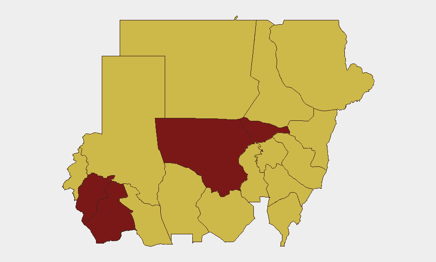
Central Darfur (risk 100) and North Kordofan (94.2) drive the highest composite threat scores, reflecting sustained inter-communal and militia violence, displacement, and limited state authority. Al Khartum (82.6), the capital, remains a secondary hotspot due to dense population, fragmented security control between SAF and RSF factions, and potential for rapid escalation. The Blue Nile, River Nile, Aj Jazira, and eastern states (Red Sea, Al Qadarif, Kassala, Sennar) all score at 70, indicating persistent but lower-intensity conflict, resource competition, and humanitarian access barriers. Organizations with personnel or assets in Darfur and Khartoum should assume heightened risk of abduction, assault, detention, and movement restriction; eastern states present secondary risk related to militia activity and roadside incidents.
How GeoBit Would Assist
Teams can deploy AOI Monitoring & Early Warning on high-risk state boundaries (Central Darfur, North Kordofan, Khartoum) with real-time alerting to incident signals and social-media chatter. Conflict & Military battle mapping and force-structure tracking provide situational clarity on SAF and RSF disposition, reducing blind spots in movement planning. Multi-language OSINT fusion and entity extraction (X/Twitter, Telegram, local media) enable continuous monitoring of commander statements, checkpoint locations, and localized security shifts hours before they affect ground operations.
7-Day Outlook
Diplomatic escalation is likely to continue, with potential for symbolic counter-statements or targeted sanctions announcements; this rarely translates to immediate tactical change on the ground but may trigger SAF/RSF messaging or localized intimidation. Civilian harm allegations will persist and amplify international attention, though operational access and conflict intensity in Darfur and eastern states will remain the primary driver of humanitarian and security risk. No major ceasefire or military repositioning is anticipated in the next 7 days; organizations should assume current threat levels and maintain heightened vigilance on movement, communications security, and staff welfare in Khartoum and Darfur.
Highest-Risk Areas — Ranked
| # | State / Region | Risk |
|---|---|---|
| 1 | Central Darfur State | 100 |
| 2 | North Kordofan State | 94.2 |
| 3 | Al Khartum | 82.6 |
| 4 | South Darfur State | 81.6 |
| 5 | Blue Nile | 70 |
| 6 | River Nile State | 70 |
| 7 | Aj Jazira | 70 |
| 8 | Red Sea State | 70 |
| 9 | Al Qadarif State | 70 |
| 10 | Kassala State | 70 |
| 11 | Sennar State | 70 |
| 12 | West Kurdufan State | 70 |
Sources
Previous Daily Briefs
A new Sudan brief is written every day — each with its own risk map and downloadable CSV. Here's the last week; use the calendar to go further back.
📅 Browse every day by calendar →
Highlighted days have a brief. Tap a day for that day's map & analysis, or “csv” for that day's dataset ($5).