Situation Summary
Suriname remains a low-to-moderate risk environment (global rank #85, composite threat score 13), with no credible acute security incidents confirmed in the past 24–48 hours. Political tensions persist between parliament and executive branches, evidenced by recent public statements and a village-level dispute (flagged 13–14 July), but no escalation to civil unrest or infrastructure disruption has materialized. The security landscape is regionally fragmented: interior and eastern districts carry substantially elevated risk, while coastal and western zones remain relatively stable.
Key Developments
- Political friction / Parliamentary statements — Paramaribo (Parliament building) — 14 July 2026 — Government and parliament exchanged public statements; village-level representatives also issued statements in parallel. No violence or institutional breakdown reported, but discord signals underlying governance strain.
- Arrest or detention event — Suriname (location not specified) — 14 July 2026 — Law enforcement conducted an arrest or detention; no detail on suspect identity, charges, or outcome is currently available.
- Coast Guard operational activity — Suriname coastal waters (exact port/location unspecified) — 11 July 2026 — Routine coast guard investigation activity was flagged; no incident, maritime crime, or smuggling event confirmed.
- No acute security incidents verified — Countrywide — 11–12 July 2026 — Open-source security monitoring confirmed absence of credible reports on civil unrest, violence, or infrastructure disruption over the reporting window.
- Public-health response — Kwatta and Koewarasan, Paramaribo District — Current week — Chikungunya vector-control spraying operations underway; public-health measure, not a security incident.
Highest-Risk Areas
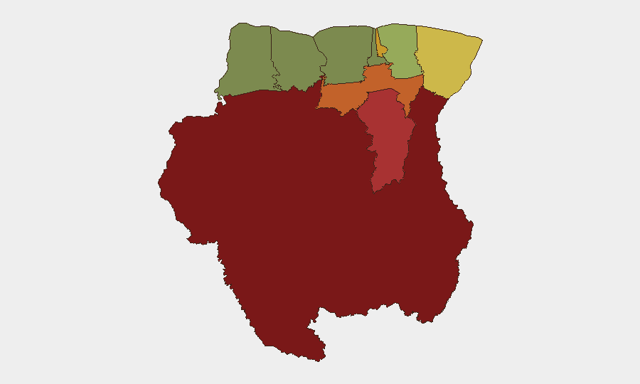
Sipaliwini (risk 92) and Brokopondo (risk 78) dominate the threat landscape, both interior/eastern regions where state presence is minimal, organized-crime activity (including illicit mining and narcotics trafficking) is endemic, and law-enforcement capacity is constrained. Para and Paramaribo districts (74 and 71, respectively) reflect a mix of criminal networks and political tension; Paramaribo's capital-region risk stems chiefly from political friction and urban crime, while Para's interior location exposes it to trafficking and resource-exploitation threats. Marowijne (risk 68) borders Guyana and French Guiana, creating additional smuggling and transnational organized-crime exposure. Coastal and western districts (Commewijne, Wanica, Saramacca, Coronie, Nickerie) carry substantially lower risk profiles.
How GeoBit Would Assist
Corporate security teams with people or assets in Suriname should deploy AOI Monitoring & Early Warning on Sipaliwini, Brokopondo, and Marowijne to capture emerging organized-crime, trafficking, or civil unrest signals before they spread to economic corridors or coastal cities. Intel Sweep and multi-language OSINT (including local news, social media sentiment analysis, and radio SIGINT) would provide continuous visibility into political discourse and street-level sentiment, flagging any cascade from parliamentary friction into urban unrest. Routing & Network Analysis capabilities enable rapid identification of secure travel corridors and alternative supply-chain routes if interior or eastern-district instability escalates.
7-Day Outlook
No imminent security deterioration is anticipated over the next week. Parliamentary tensions may continue but are unlikely to translate into street violence or institutional collapse absent a major political trigger. Interior and eastern districts will likely remain elevated-risk but stable; monitor for any organized-crime spillover into transit zones or coastal commerce hubs.
Highest-Risk Areas — Ranked
| # | State / Region | Risk |
|---|---|---|
| 1 | Sipaliwini | 92 |
| 2 | Brokopondo | 78 |
| 3 | Para | 74 |
| 4 | Paramaribo | 71 |
| 5 | Marowijne | 68 |
| 6 | Commewijne | 42 |
| 7 | Wanica | 38 |
| 8 | Saramacca | 29 |
| 9 | Coronie | 12 |
| 10 | Nickerie | 8 |
Previous Daily Briefs
A new Suriname brief is written every day — each with its own risk map and downloadable CSV. Here's the last week; use the calendar to go further back.
📅 Browse every day by calendar →
Highlighted days have a brief. Tap a day for that day's map & analysis, or “csv” for that day's dataset ($5).
Atlas — our AI intelligence desk — emails them this snapshot personally. Nothing else, no list.