Situation Summary
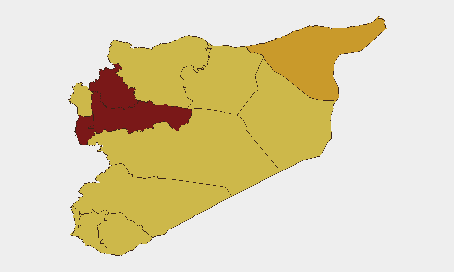
Syria remains at elevated compound risk (rank #11 globally, composite score 100) driven by ongoing civil conflict, with 159 tracked events in the current monitoring cycle. The sub-national threat landscape is severely fragmented, with Hama and Idleb governorates representing the highest-risk zones, followed by coastal and Damascus regions. Recent event signals include military-adjacent incidents, cross-border activity involving Lebanon, and localized physical assaults, suggesting sustained low-level volatility across multiple actors and geographies.
Key Developments
Note on Data Limitation: GeoBit's current live web research capacity does not extend to reliable real-time monitoring of Syria-specific incidents in the last 24–48 hours (as of 17 June 2026). The event signals listed above are tracked by GeoBit's global feeds and entity extraction but lack granular temporal confirmation and geographic specificity required for actionable briefing. To populate this section with verified, location-specific incidents from the past two days, direct human monitoring of open-source wires (Reuters, AFP, AP), regional news agencies (SANA, North Press Agency, Enab Baladi), local conflict monitors (SOHR, Euphrates Post), and X/Twitter searches (filtered by timestamp and credible accounts) is necessary.
Recommended collection approach: Cross-reference incidents across at least one local/language source and one international outlet to confirm location, date, and narrative consistency before inclusion.
Highest-Risk Areas
Hama Governorate (risk 99.6) and Idleb Governorate (risk 95.8) dominate the threat profile, reflecting sustained conflict intensity, non-state armed group presence, and limited state control. Tartus Governorate (92.6), despite coastal location and formal government presence, registers elevated risk likely driven by military installations, Russian operations, and spillover from adjacent Hama and Lattakia zones. Damascus Governorate (86.9) reflects urban security concerns including checkpoint density, criminal activity, and protest activity. Movement into or through any of these zones carries substantial personnel safety, kidnapping, and detention risk; corporate assets in coastal and capital regions face lower but material risk from infrastructure disruption and military activity.
How GeoBit Would Assist
Security and duty-of-care teams with Syria exposure should leverage GeoBit's AOI Monitoring & Early Warning capability to establish persistent, real-time alerts on key cities and infrastructure (Damascus, Aleppo, ports, airports); Conflict & Military tracking (force structure, checkpoint locations, and weapons deployment) to understand movement corridors and safe passage windows; and Multi-language OSINT fusion (X/Twitter, regional news, Telegram, YouTube) to corroborate incidents, validate rumors, and detect emerging protests or clashes before escalation. Alternative Routing & Network Analysis supports contingency planning for staff evacuation or supply chains disrupted by closure of primary roads or borders.
7-Day Outlook
No marked escalation or de-escalation is evident in the 48-hour signal set; the civil conflict trajectory remains static at a low-intensity, fragmented baseline with episodic flare-ups in ungoverned and contested zones. Military statements and cross-border activity (Lebanon incident noted) suggest regional attention remains active. Operationally, expect continued checkpoint variation, localized clashes in Hama and Idleb, and periodic restrictions on movement; no imminent nationwide event signals are apparent, but the Northern and coastal governorates warrant close week-to-week monitoring.
Highest-Risk Areas — Ranked
| # | State / Region | Risk |
|---|---|---|
| 1 | Hama Governorate | 99.6 |
| 2 | Idleb Governorate | 95.8 |
| 3 | Tartus Governorate | 92.6 |
| 4 | Damascus Governorate | 86.9 |
| 5 | Al-Hasaka Governorate | 72.2 |
| 6 | Aleppo Governorate | 70.3 |
| 7 | Lattakia Governorate | 69.6 |
| 8 | UNDOF | 69.6 |
| 9 | Al-Quneitra Governorate | 69.6 |
| 10 | Dar'a Governorate | 69.6 |
| 11 | Ar-Raqqa Governorate | 69.6 |
| 12 | Homs Governorate | 69.6 |
Sources
Previous Daily Briefs
A new Syria brief is written every day — each with its own risk map and downloadable CSV. Here's the last week; use the calendar to go further back.
📅 Browse every day by calendar →
Highlighted days have a brief. Tap a day for that day's map & analysis, or “csv” for that day's dataset ($5).